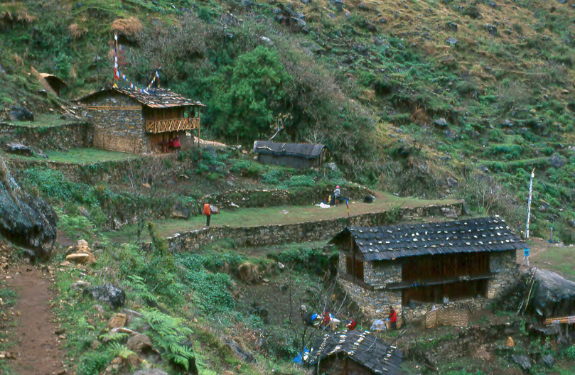
A catalog of images from Kangchenjunga Conservation Area at the turn of the 21st Century
Amjilassa Campsite (19 May 2001)
At the turn of the 21st Century, Kangchenjunga Conservation Area (KCA) was being developed in the easternmost part of Nepal. This catalog of images provides a visual record of the infrastructure and environmental condition along trekking routes in the Kangchenjunga area at this time. We focused on facilities built to accommodate trekking tourism (designated campsites, lodges, tea shops, and bridges) because “sustainable ecotourism” was viewed as an important component of the KCA conservation and development strategy. This document was compiled in order to gauge how tourism development would affect the area.
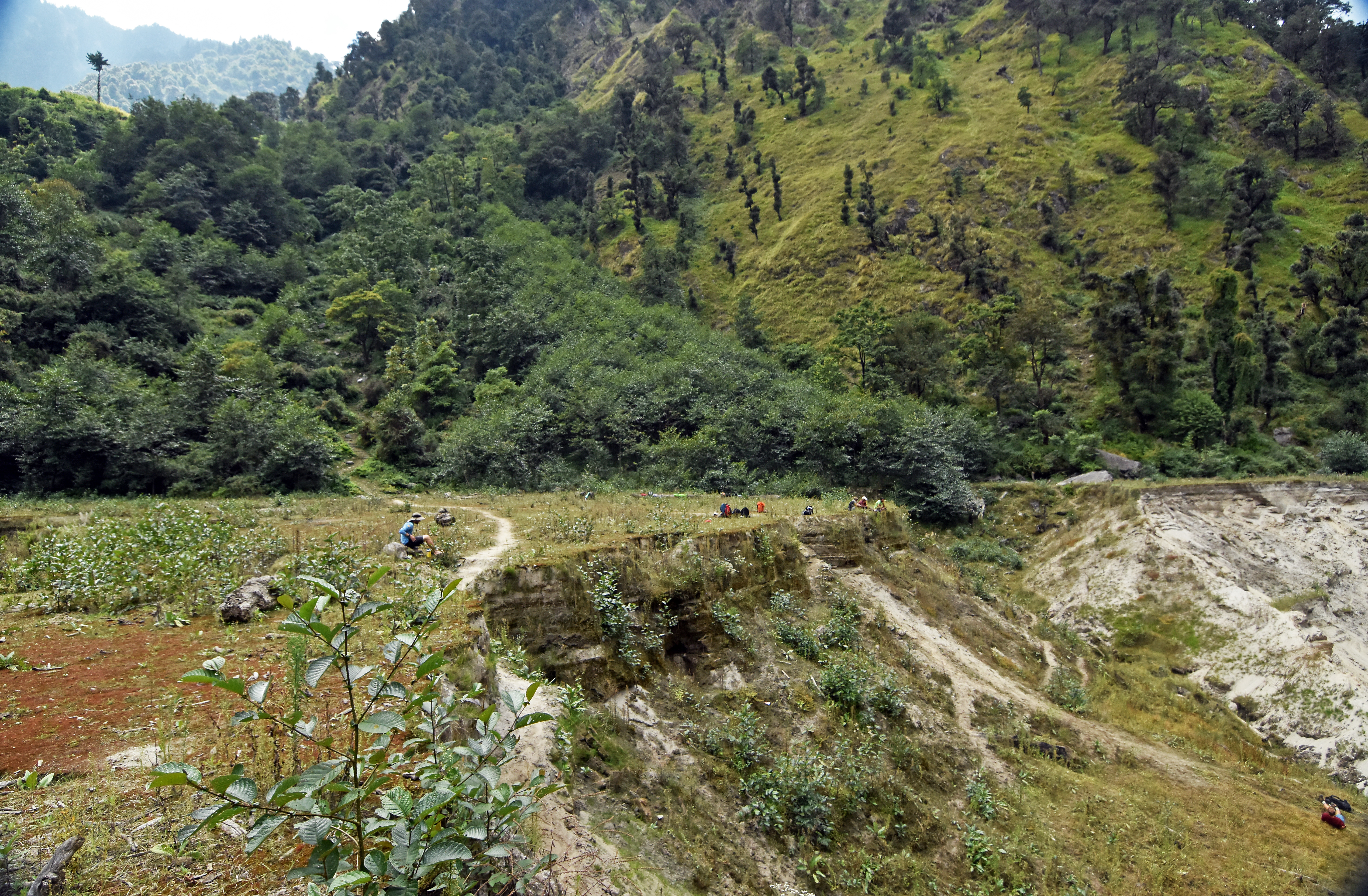
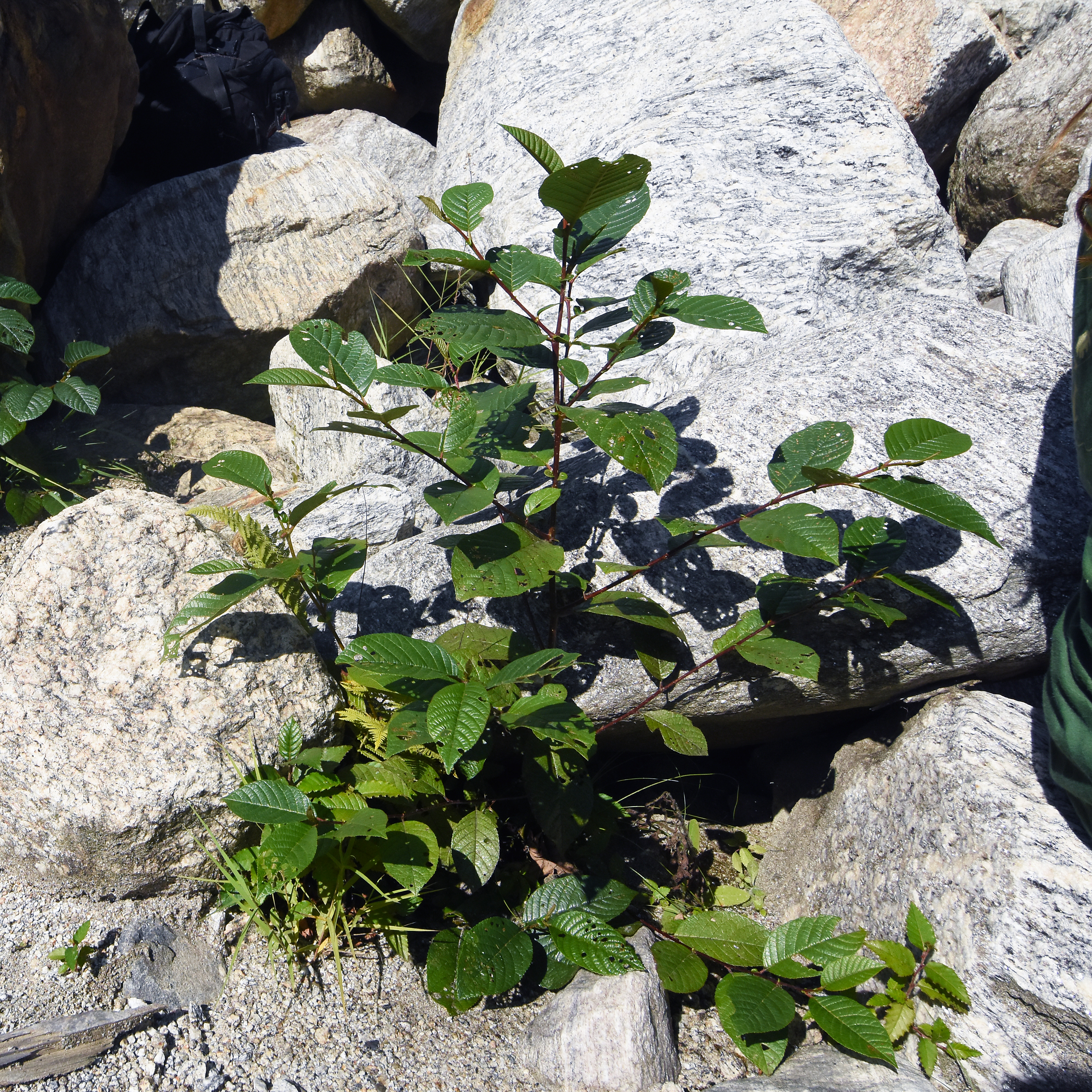
We also marked permanent forest plots in four locations: Dhupi Bhanjyang above Yamphudin, Tseram in the Simbuwa Khola, Yamtori Khola, and Ghunsa Village. Within forest plots, we measured and identified each tree to species and took photographs (which are included here).
Nearly all the 150+ images in this collection include location data, determined by GPS to within 0.001 minutes of latitude and longitude and 10 meters elevation. In practice, our (uncalibrated) GPS data is usually reliable to about 0.05 minutes (about 100 meters) or better. We also provide supplementary information gathered by students and staff through personal observation or interviews with local residents.
When we made this collection in 2001-2, we intended that it would provide a baseline by which to measure the effectiveness of conservation and development programs. We hope this catalog will be useful to those who are interested in how the Kangchenjunga Conservation Area has ‘developed’ overz the past couple of decades.
Yulong Geopark modifies its natural landscape with fake stuff copied from other places in China. But it’s still beautiful.
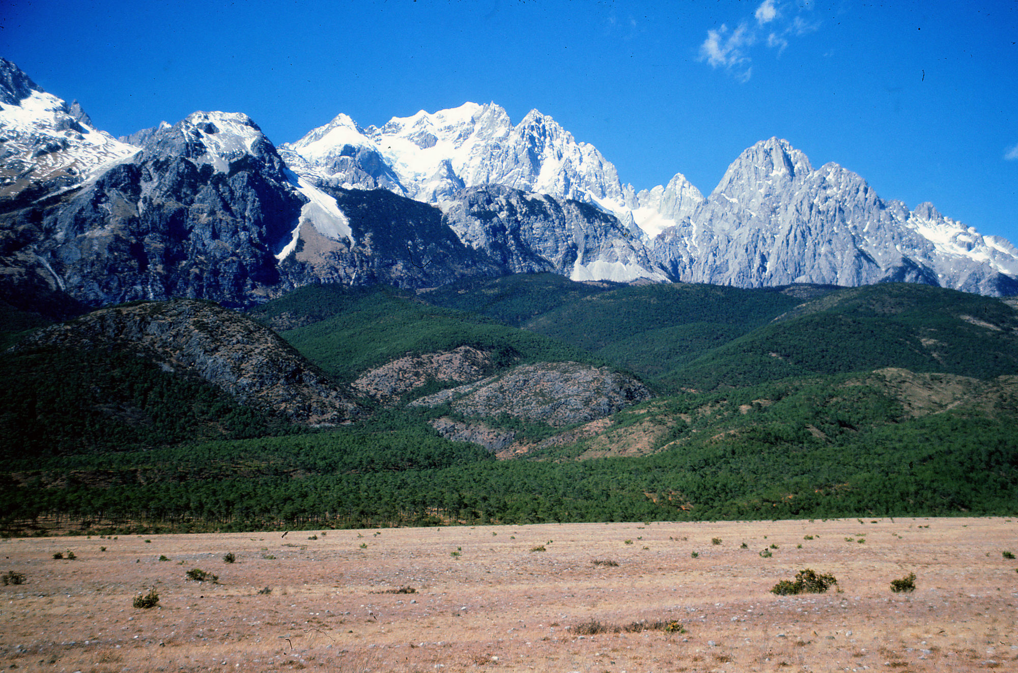
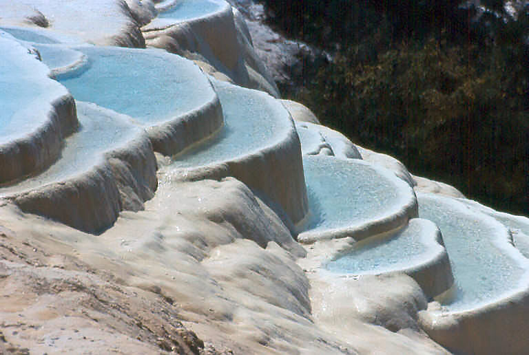
Upper Lijiang Plain in 1987. Yulong Shan, the Jade Dragon mountain range, cradles Eurasia’s southernmost glacier. The area is managed as a scenic site for tourism and this means a golf course, multiple cable cars to high elevation, and the installation of artificial landscape features that riff on other scenic sites in other parts of China. In this image from January 1987, pine grows on old moraine deposits, and Satsetso (5596 m elevation) rises in the distance.
Once upon a time, meadows to the east of the Yulong Snow Mountain were called Ganhai 干海, which means the dry sea, probably because the limestone is so porous that low spots don’t hold much water, even in the rainy season.
Today Ganhai is still Ganhai, but on maps younger than 30 years, gan is written with a different character, pronounced the same, that means sweet orgiving. Ganhai, the dry sea (干海) has become Ganhai, the sweet sea (甘海).
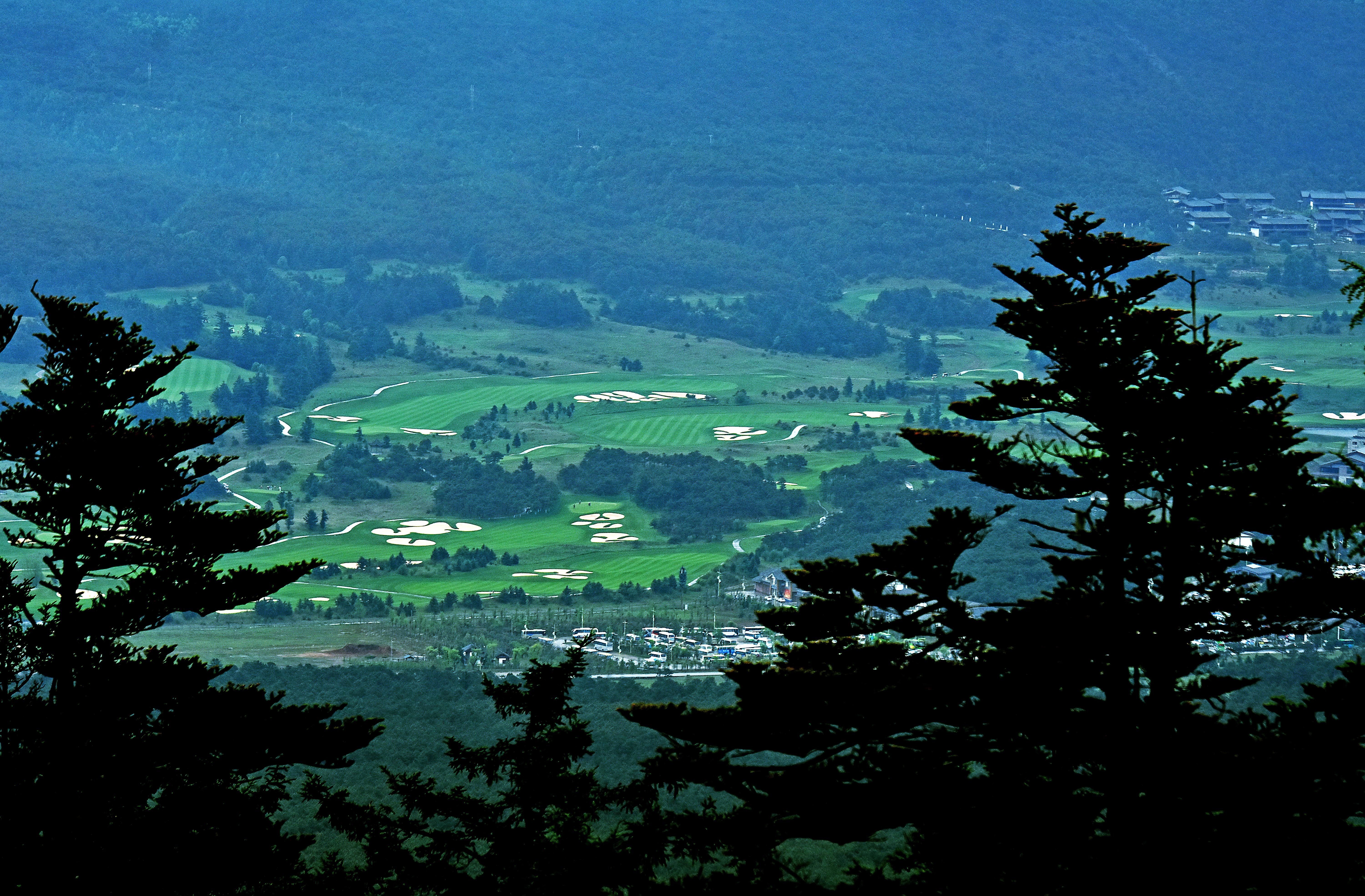
Here is the main tourist service center for Jade Dragon Geo-Park with golf course, villas, parking lot, shopping center and lots of other stuff.
Yulong Xueshan, or Jade Dragon Snow Mountain, in the Tibetan borderlands of Yunnan Province, China is a sublime massif of limestone and ice that frames one of the world’s deepest river valleys. Because the topography in this frontier between China and Indo-Burma is so isolating, cultures have developed with their own written language and vernacular sense of place. In the early 20th Century an American explorer named Joseph Rock described the region in a series of National Geographic articles. Then with Communist Liberation in 1949, everything was closed to outsiders. Foreign visitors returned in the 1980s and since the end of the 20th Century, the Jade Dragon Snow Mountain National Geopark has received many, many millions of domestic tourists who have come into the area on day excursions from the nearby city of Lijiang.
Some of the day-trippers are surely drawn by the scenery and the bracing mountain air, others come because their friends have, or through circumstances beyond their control, perhaps a corporate incentive program. They move among the high elevation wonders on green buses, walk paths or boardwalks holding canned oxygen, queue for cable car excursions, and shop.
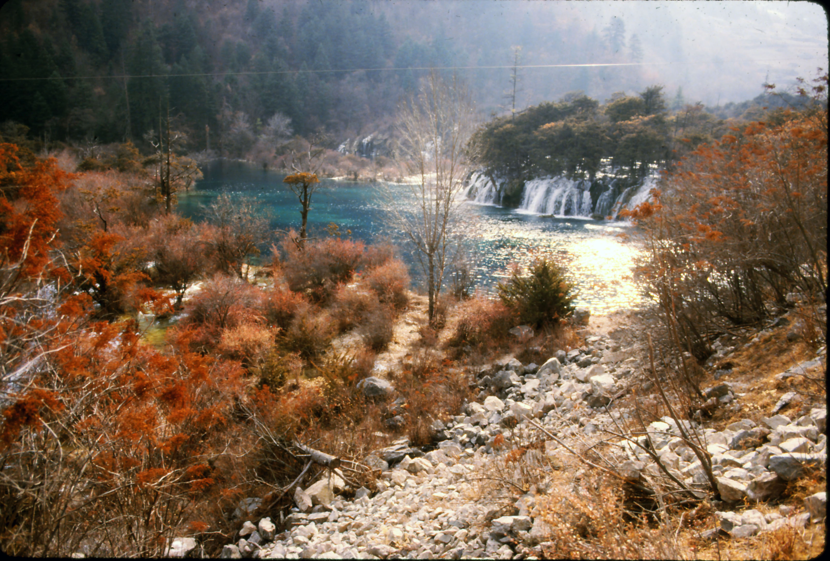
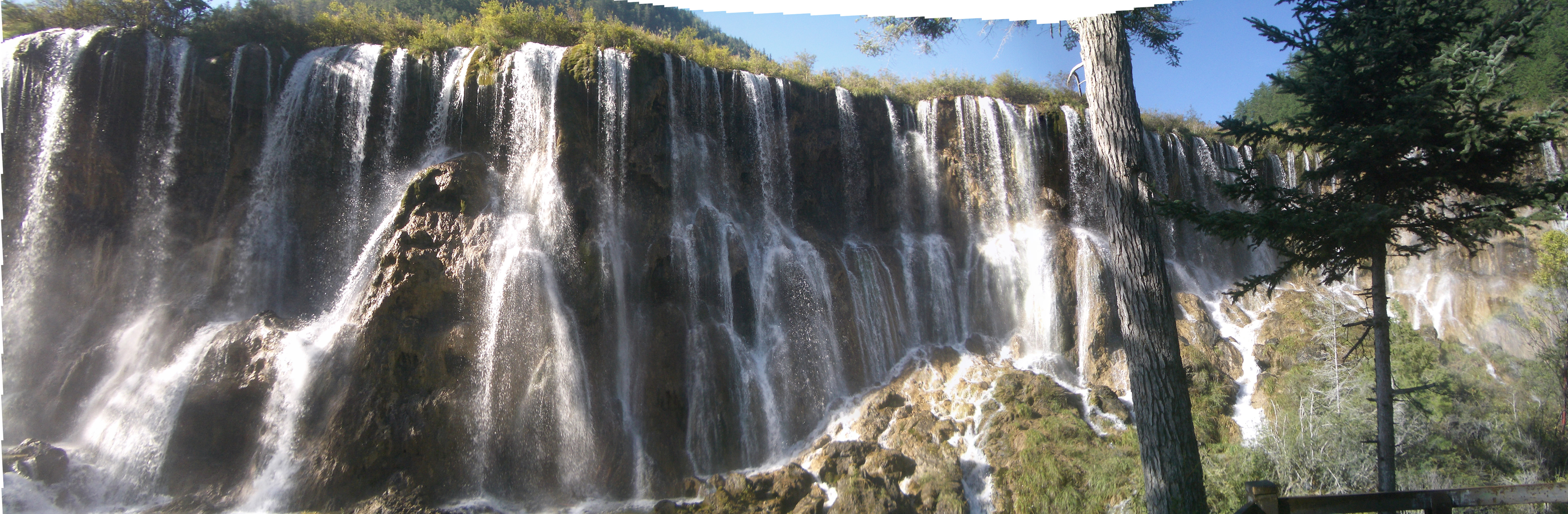
Jade Dragon Geopark may be one of the most popular scenic sites in Yunnan, but there is a national park in Sichuan Province called Jiuzhaigou that is even more famous. Perhaps because they evoke a traditional garden, the waterfalls, limestone shoals and stunningly clear pools of Jiuzhaigou have become icons of natural beauty in China.
Back around the turn of the century, Jade Dragon’s Baishui stream stated getting adorned with artificial landscape features that mimic those of Jiuzhaigou. It’s not ugly, but it can be jarring as hell in a ‘geopark’ where landscape authenticity is a real, tangible thing that ought to be defended.
Here are some comparative photos from Jiuzhaigou and Jade Dragon Geopark. Some of the Jiuzhaigou images are from when Craig Kirkpatrick and I visited as guests of the Sichuan Ministry of Urban and Rural Environmental Protection in 1986 and don’t show the development and the mass tourism that have come in since Jiuzhaigou got famous in the 1990s. Having said that, I do believe Jiuzhaigou has done a fine job managing the crowds. There are no cable cars and no fake landscapes.
First some scenes of the Shuzhen Village part of Jiuzhaigou from 32 years ago, along with a 2015 Google Earth image for context. It was very cold at the time, and the whole place was almost deserted. Simple boardwalks traversed the stream, and the locals maintained water-powered prayer wheels. Nothing had been paved yet.
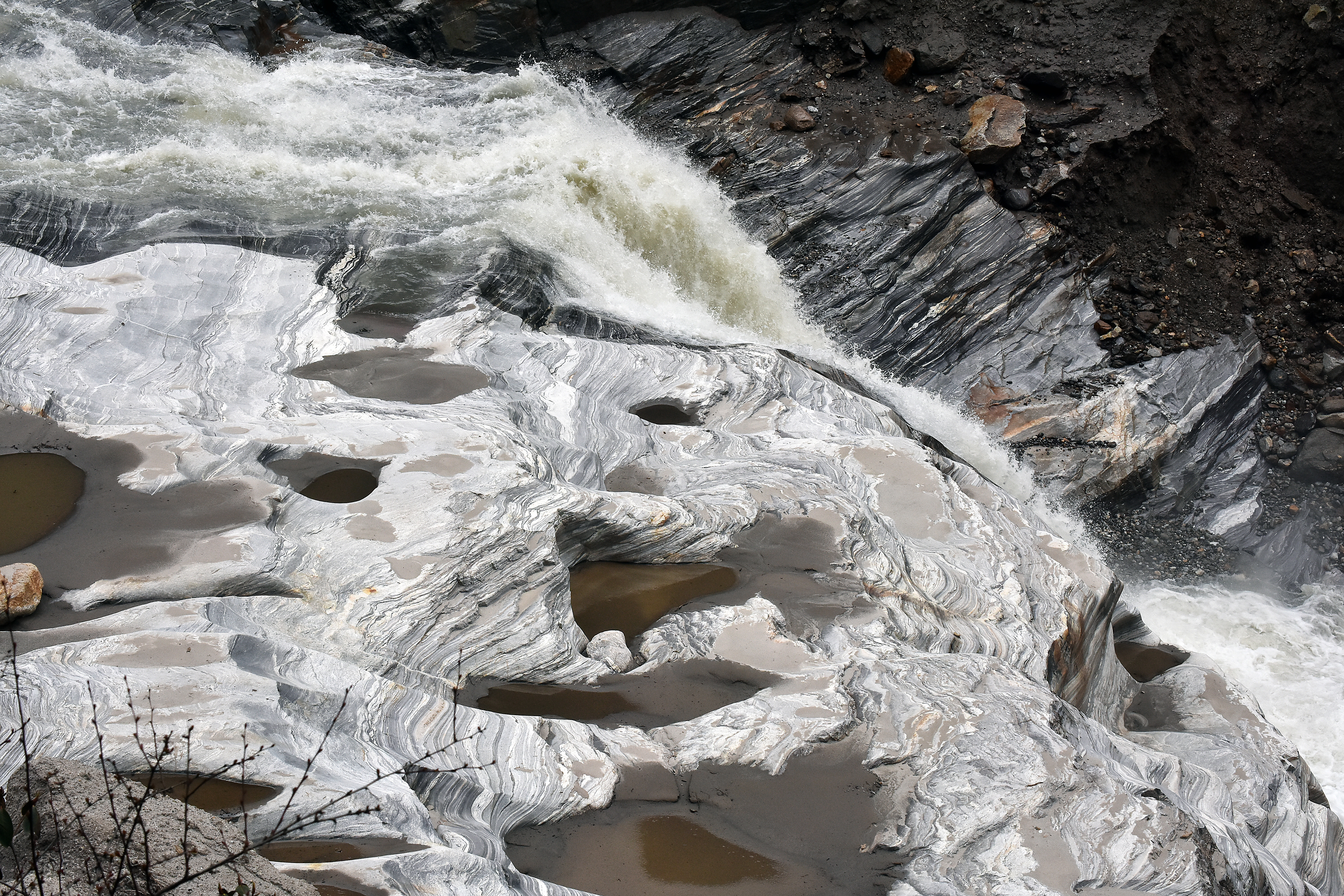
Here at Shuzhen, the river is interrupted by shoals of calcium carbonate limestone that have precipitated to make dams with waterfalls. It is in the nature of these kinds of carbonate landscapes to self-organize their architecture so that water flows evenly over a the crest of the entire shoal, all the way across from left to right. Shrubs grow where they can, anchored in the fresh limestone, roots nourished by the passing river water.
At Jiuzhaigou, the stream that passes by Shuzheng Village is interrupted by a series of dams that were formed by precipitation of calcium carbonate from the water. In the top image, the brown shrubs are mainly growing on these carbonate deposits. They green-up in the summer. These images are from December 1986, just as Jiuzhaigou was beginning to be developed for tourism by the Sichuan Ministry of Urban and Rural Environmental Protection.
Shuzheng carbonate terraces cross the river, with Shuzheng Village peeking out on the right. One of the scenic highlights of Jiuzhaigou National Park. Looking upstream, October 2015. Image courtesy of Google Earth.
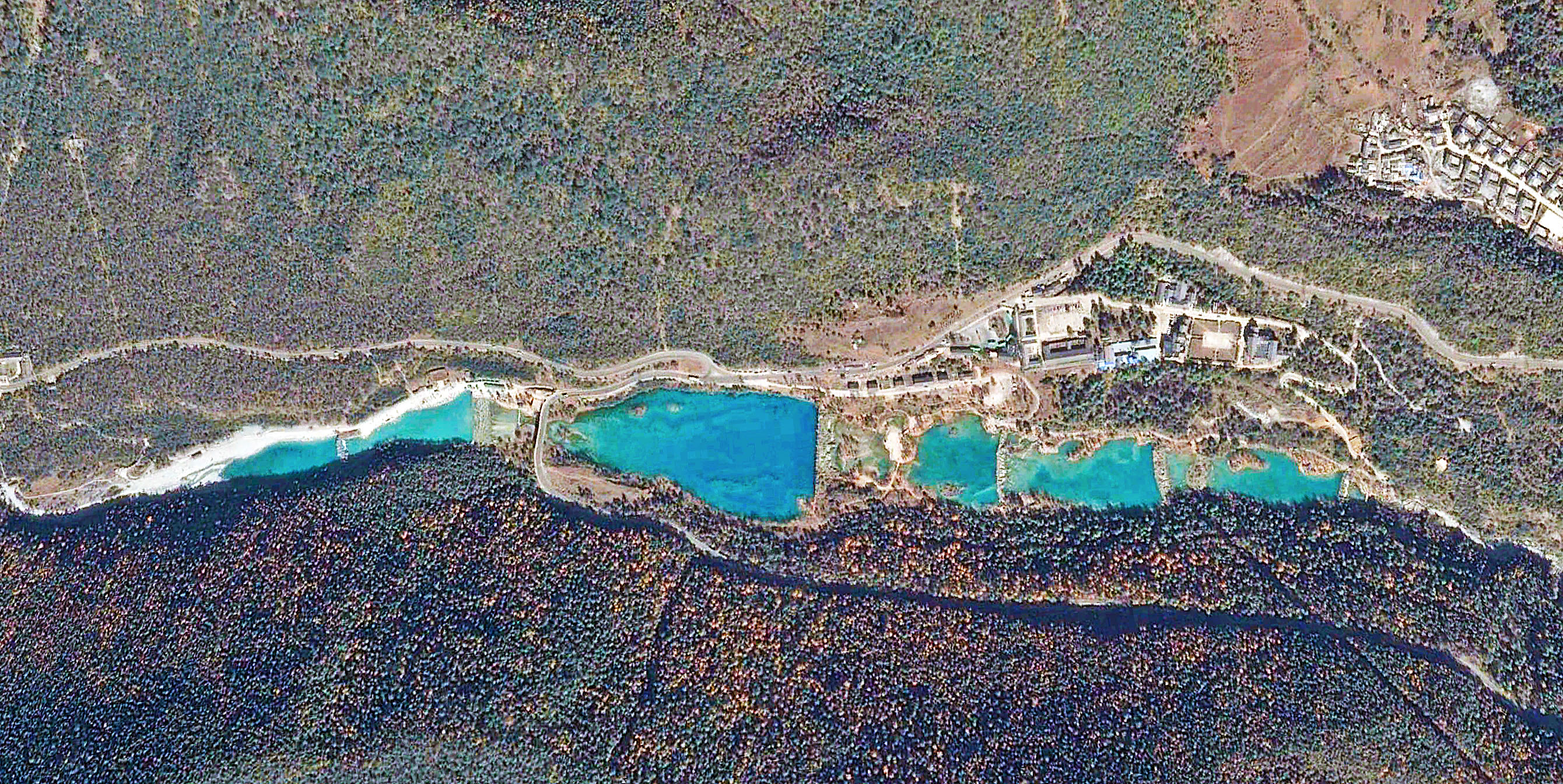
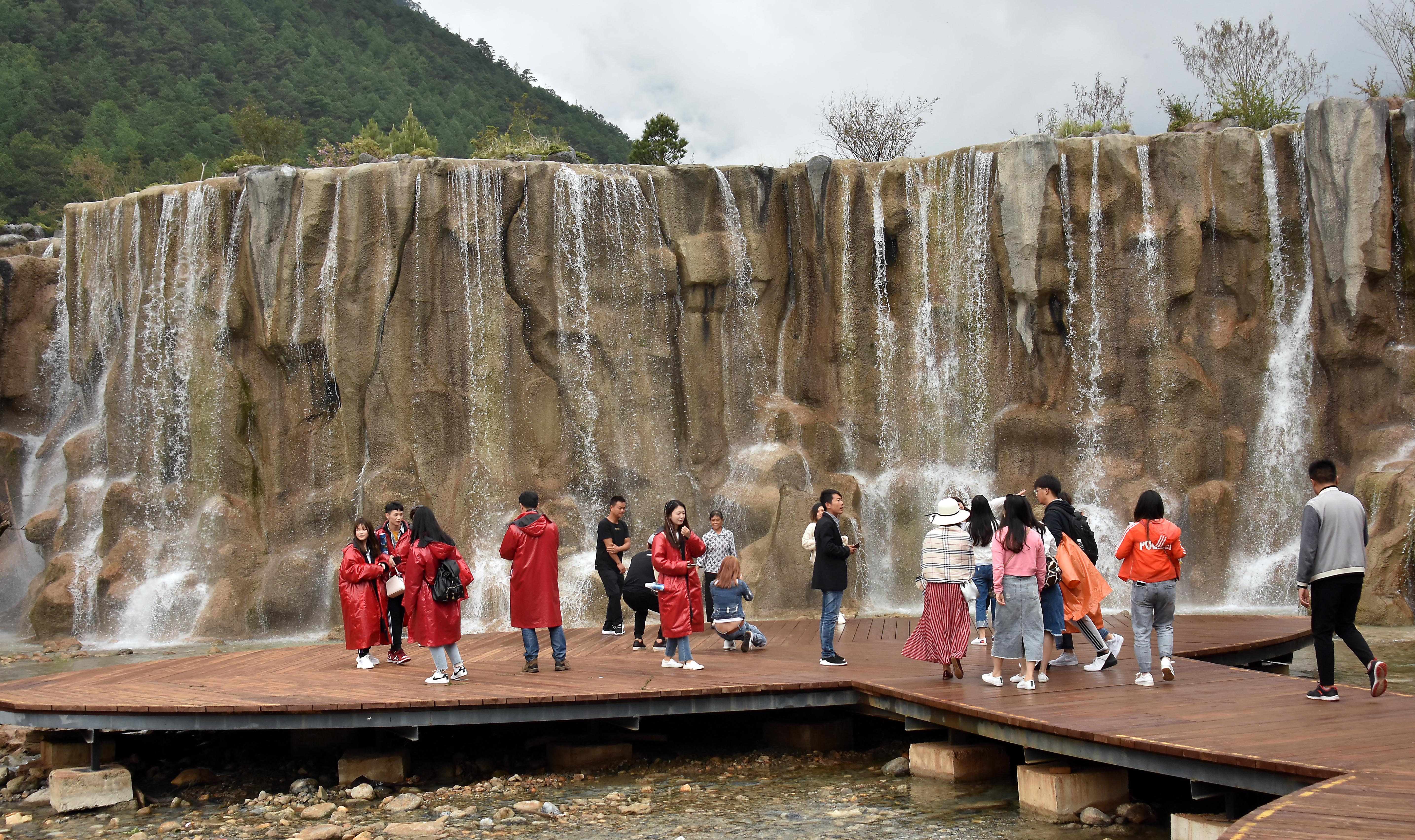
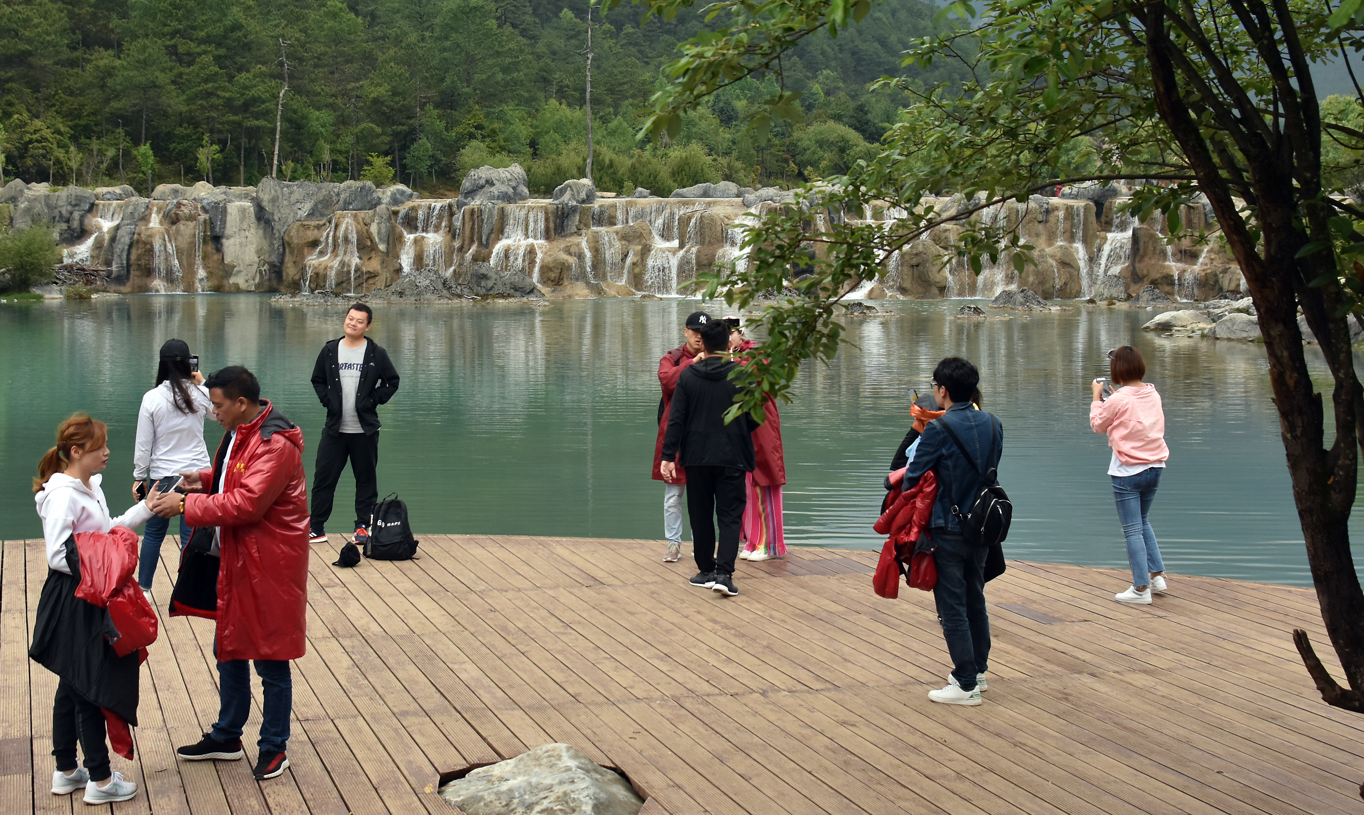
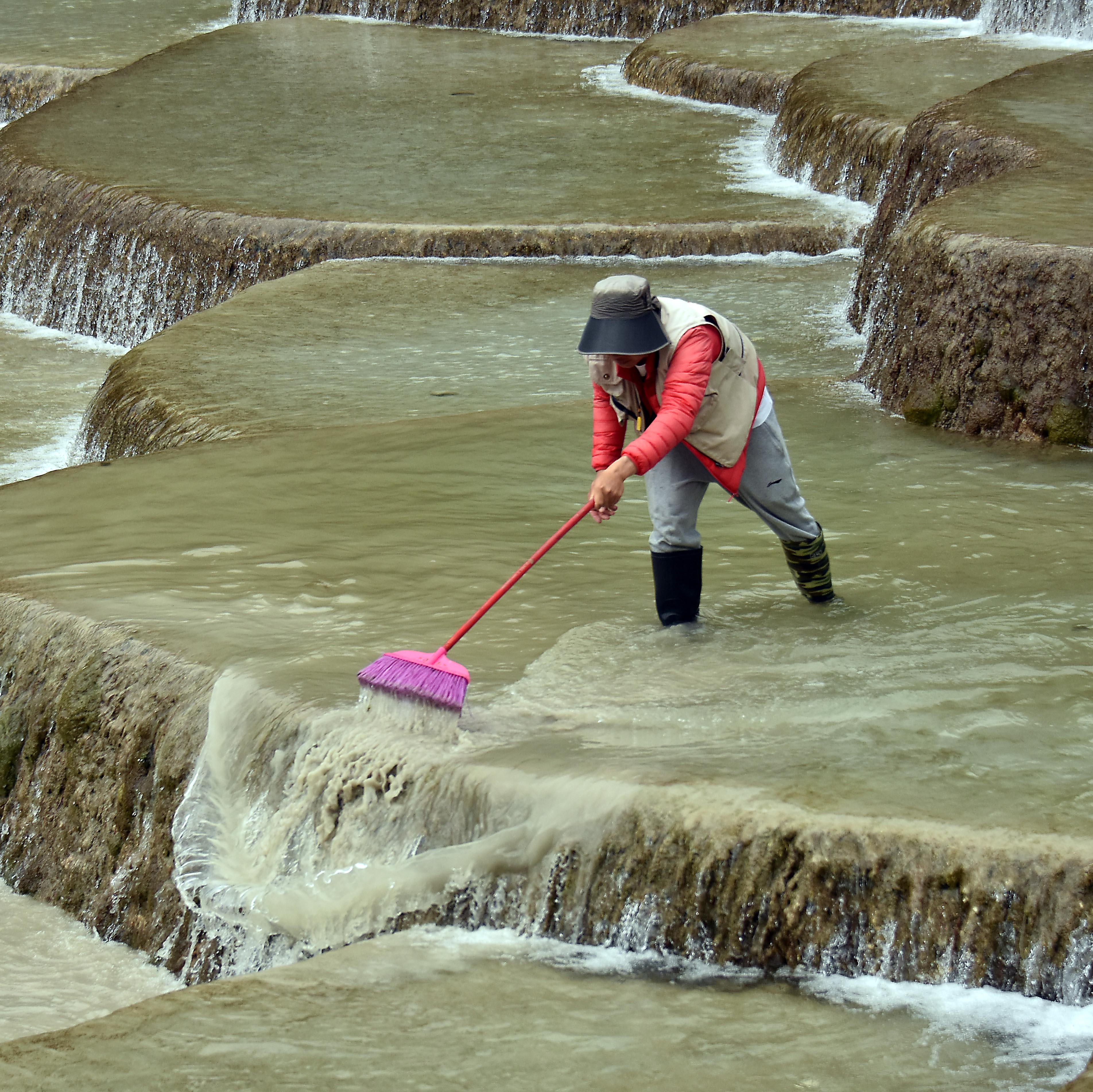
So, at some point about 20 years ago, someone in the loop at Jade Dragon Geo-Park down in Yunnan decided one of their streams should get fake landscape features that look like the depositional carbonates of Jiuzhaigou.
Baishui stream, the one targeted for the upgrades, is now dammed in five places, and various dams mimic different specific scenic features of Jiuzhaigou.
The Baishui stream is impounded with a series of dams that are decorated to look like places at Jiuzhaigou National Park in Sichuan. Looking downstream, June 2018.
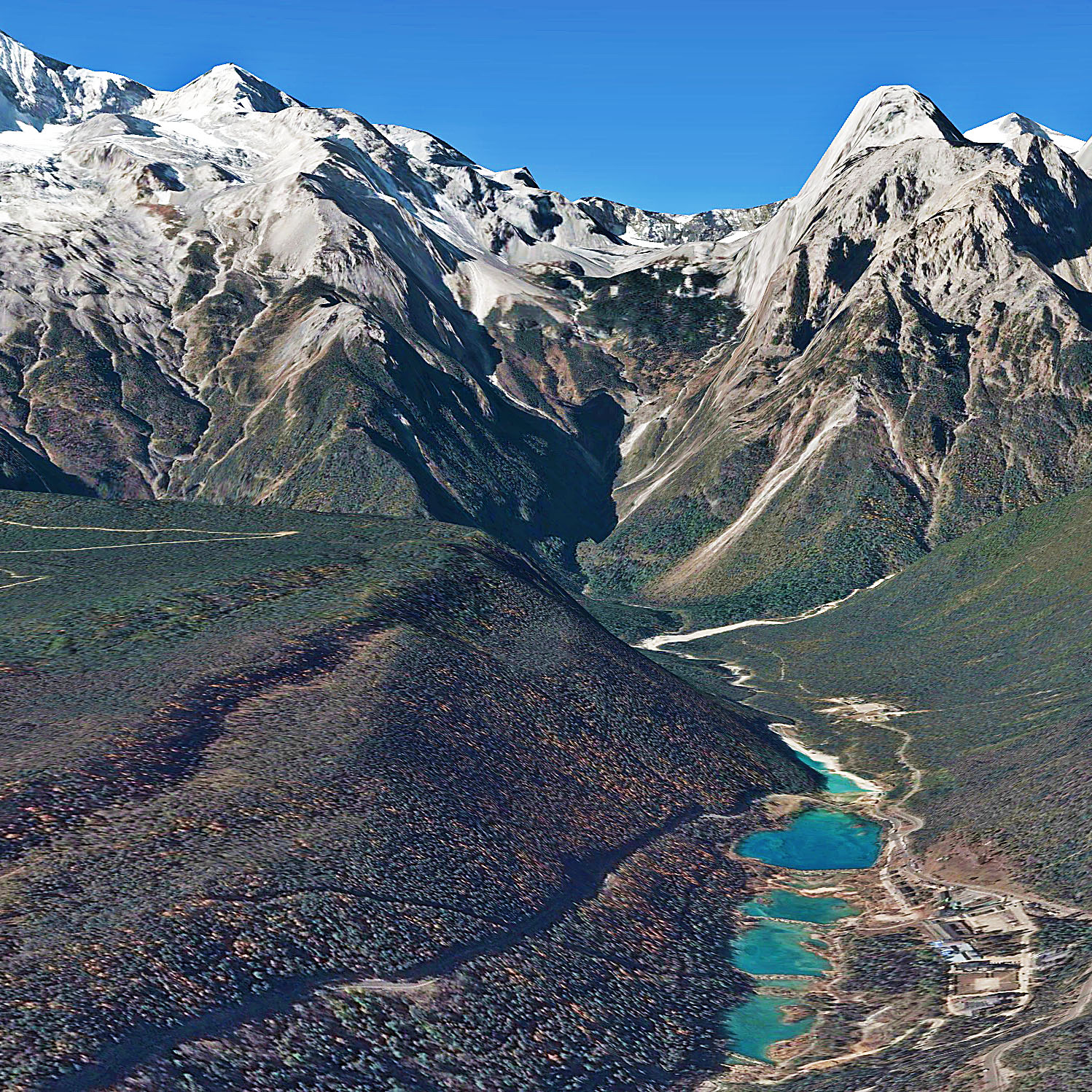
The Baishui river installation from above, November 2017. Couretsy Google Earth.
The Baishui river installation, looking west toward the high mountains, November 2017. Courtesy Google Earth.
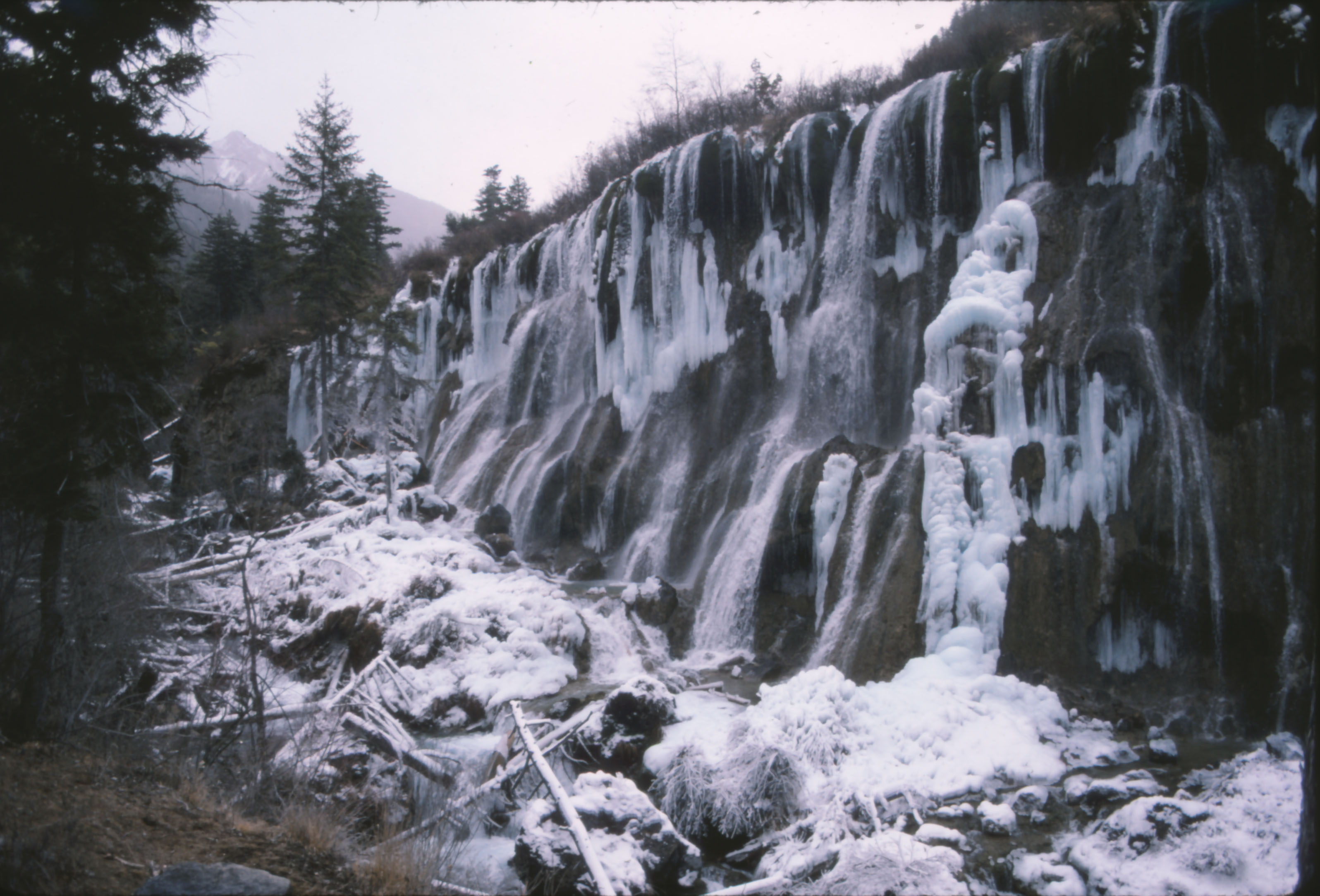
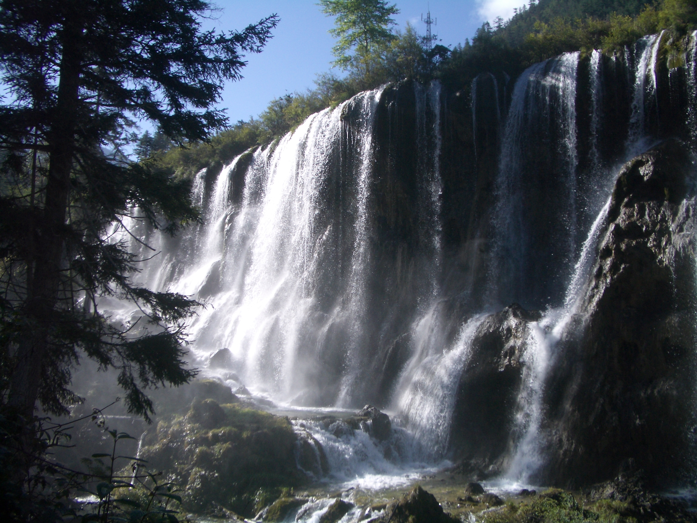
Here is Nuorilang, one of Jiuzhaigou’s biggest carbonate waterfalls, photographed in early winter 1986 and late summer 2006.
Two views of Nuorilang Waterfall, a depositional feature at Jiuzhaigou National Park. The first is from December 1986, prior to development of the scenic site. The second is from September 2006. Dead timber has been removed from the scene. Perhaps the tree trunks in the 1986 image are from logging operations that have been curtailed.
The original Nuorilang waterfall at Jiuzhaigou, Sichuan, September 2006. In this frontal view, it’s possible to see how patterns of deposition have caused the water to cascade evenly over the entire breadth of the shoal. Under a normal, erosional regime, it would never happen like this — the river would cut narrow channels.
And here is the copy at Jade Dragon Geopark, June 2018
The fake Nuorilang waterfall, built into one of the check dams at Baishui stream in Jade Dragon Geo-Park, Yunnan. Here the water is distributed along the breadth of the falls through careful engineering. Over time, perhaps the water will incise a few larger channels.Here is a depositional shoal at Jiuzhaigou, winter 1986.
This waterfall near Shuzheng Village in Jiuzhaigou was also copied at Jade Dragon Geo-Park. December 1986.
And here’s Jade Dragon’s copy in June 2018.
This Baishui check-dam appears to riff on one of the shoals at Shuzheng, Jiuzhaigou. Again, comparing December 1986 to June 2018.
Bathtub terraces are a depositional limestone formation that has grown in various places throughout the mountains of southwest China. This image shows a set of them at Baishui Tai in the Haba Mountains of Northern Yunnan (not to be confused with the Baishui host stream at Jade Dragon Geopark). But there are bigger bathtub terraces at Huanglong, next door to Jiuzhagou. It’s uncertain which specific formation inspired the concrete terraces at at Jade Dragon, shown in the bottom photo.
This is natural. Baishui Tai depositional terraces have self-organized by feedback between precipitation and gravity. Calcium carbonate precipitates where water cascades over the rim of each terrace, producing dozens of little bathtubs full of clear water. The formation evolves rapidly, adding several millimeters a year, then when the source spring shifts, the formation decomposes. This natural formation lies at the foot of Haba Mountain, across the Jinsha river to the north of Jade Dragon Geo-Park.
This is a man-made check dam built from concrete that mimics natural bathtub terraces like the ones above.
Although the artificial feature is cleaned regularly, it is not as white as the natural one because it is not being continually renewed.
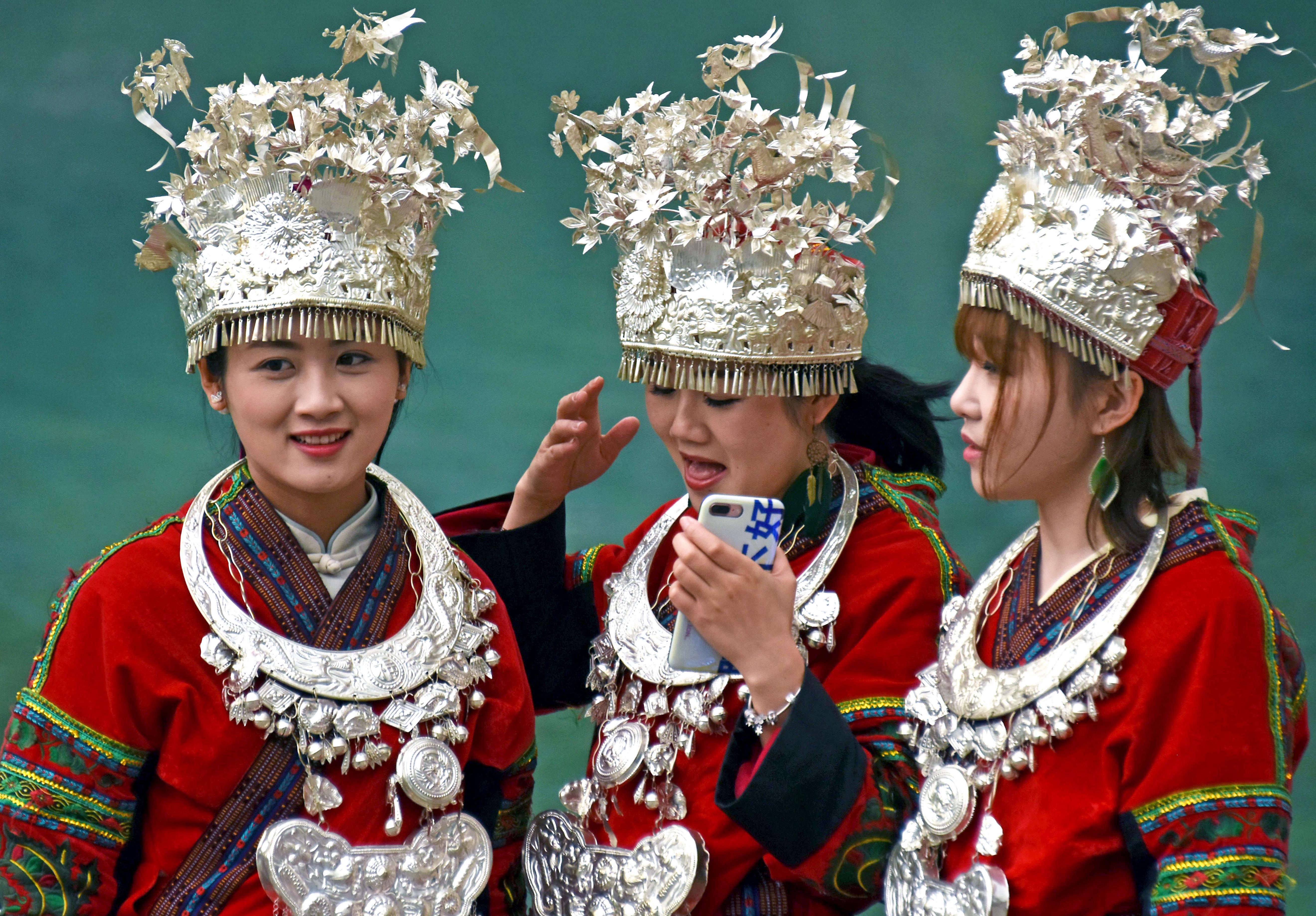
Depositional carbonate is not the only thing that gets appropriated at the Jade Dragon Geo-Park. Visitors pay to dress in generic ethnic minority clothing and accessories. These tourists’ hats and ceremonial necklaces are inspired by Miao silver from other parts of southwest China. The provenance of the jackets is less certain.
Torrential rains retooled a river valley in the Kumaon Himalaya. Here’s an account of the flood disaster with a few ‘before’ and ‘after’ images.
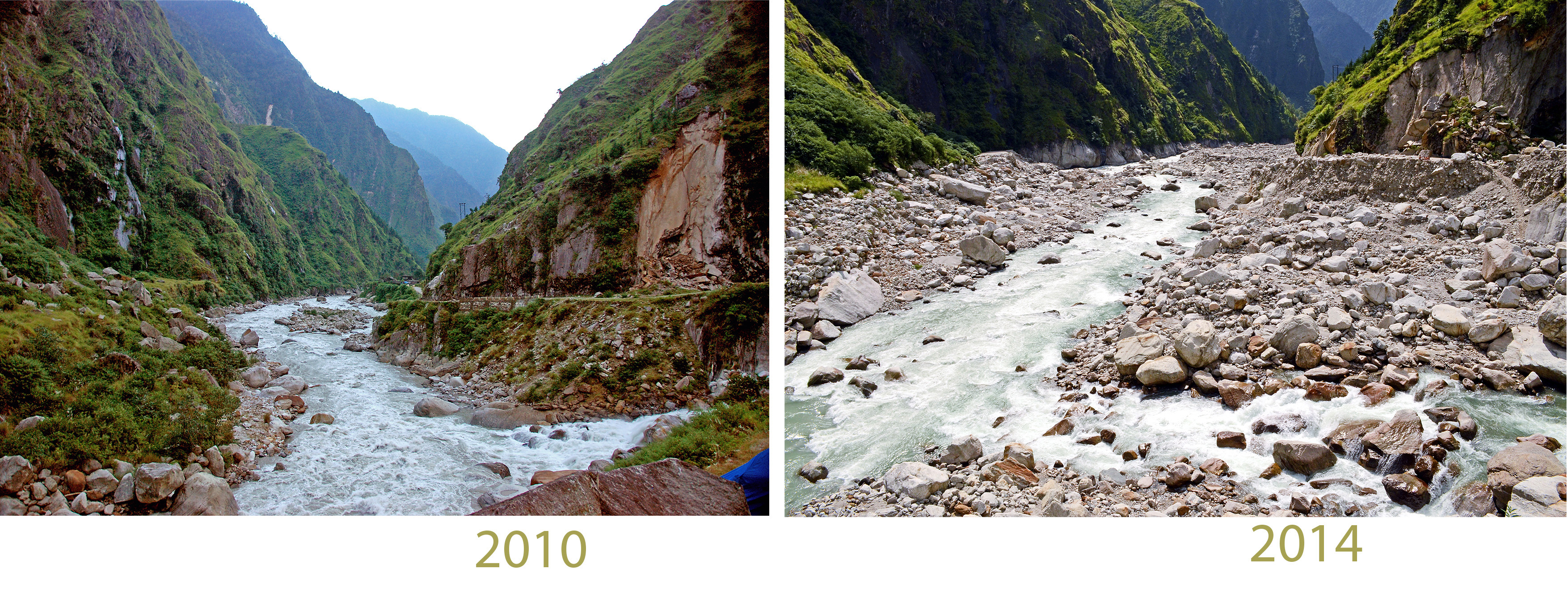
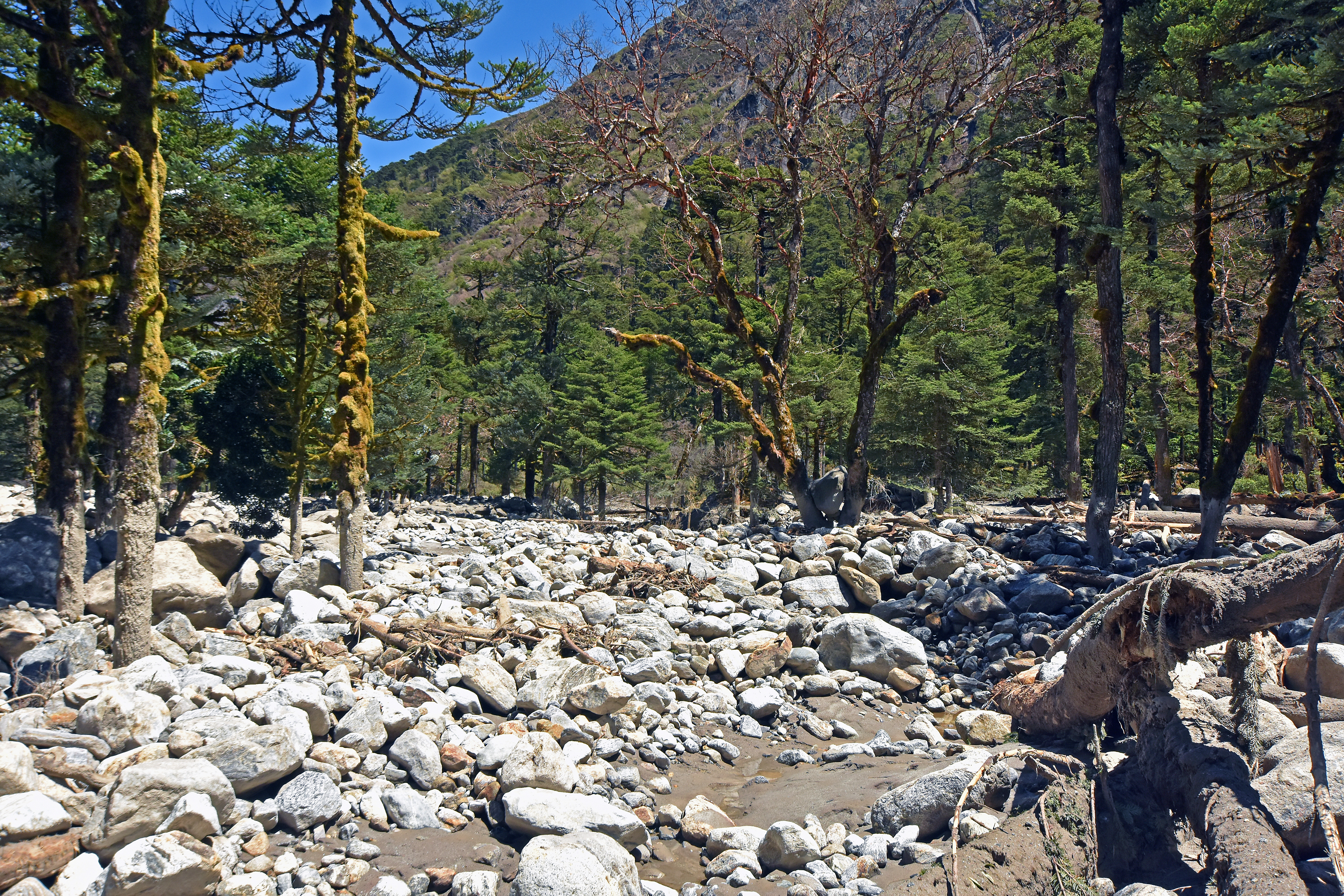
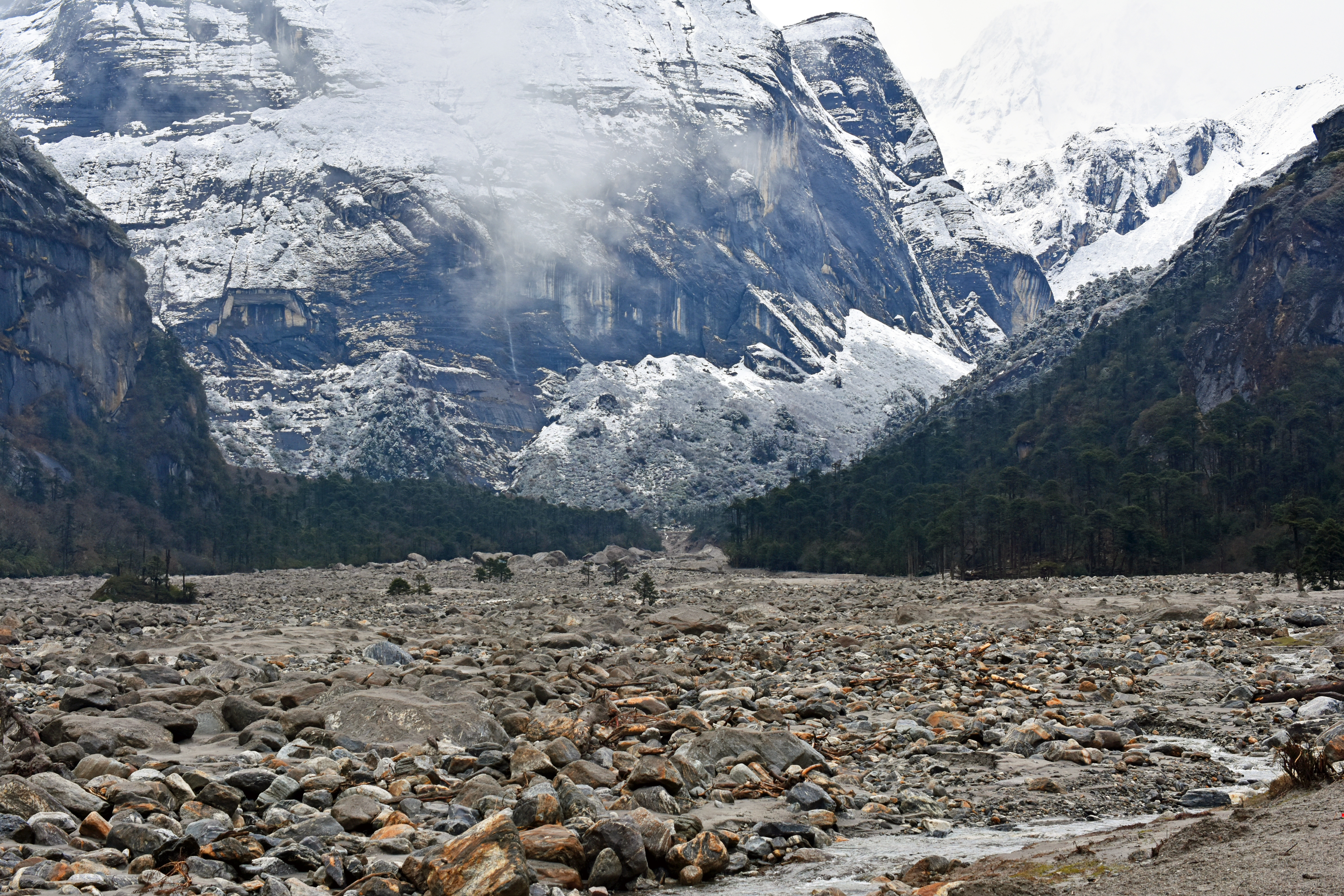
Umachiya river valley, Uttarakhand in 2010. This small catchment, which feeds into Darma Valley, is seated at the foot of the High Himalaya, which means it catches a lot of rain and floods easily.
Over a three day period in mid-June 2013, the mountains of Uttarakhand, India got 60-90 cm (more than two feet) of rain. Lodges and shops around ancient pilgrimage sites at the headwaters of the Ganges river were washed away or buried in rock debris. Whole market towns, footpaths and motor roads were obliterated and more than 5000 people died.
Flooding was also severe in Kumaon, along Uttarakhand’s eastern border with Nepal. Here the 2013 flood retooled the Mahakali river valley and its tributaries including one place I’m somewhat familiar with called Darma valley. Seven times during 2009-2016, I have helped to bring university students into Darma Valley with the Wildlands Studies Program, a partner of Western Washington University and Wildrift Adventures, an iconoclastic Kumaon-based purveyor of adventure and discovery who provided fantastic logistical support and linkages with the Darma valley community that we could never hope to find elsewhere.
Wildrift staff weathering a sun shower in Tejam meadow, 2016. Locals say when rain and sun come together, the dog is mating with the jackal.
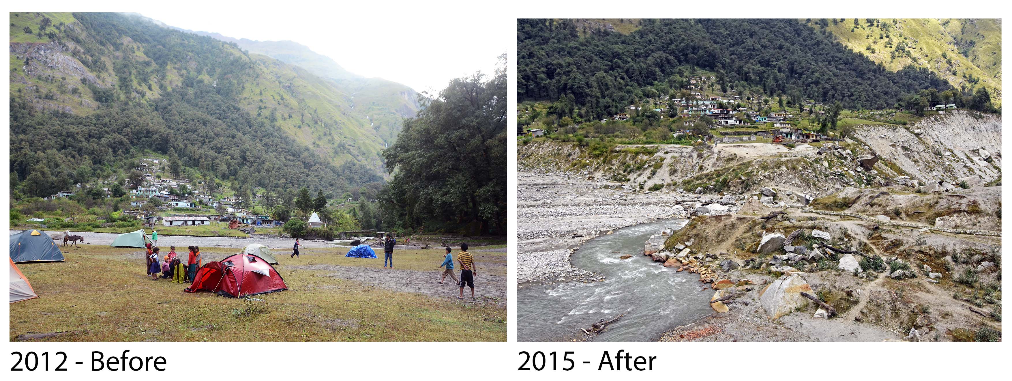
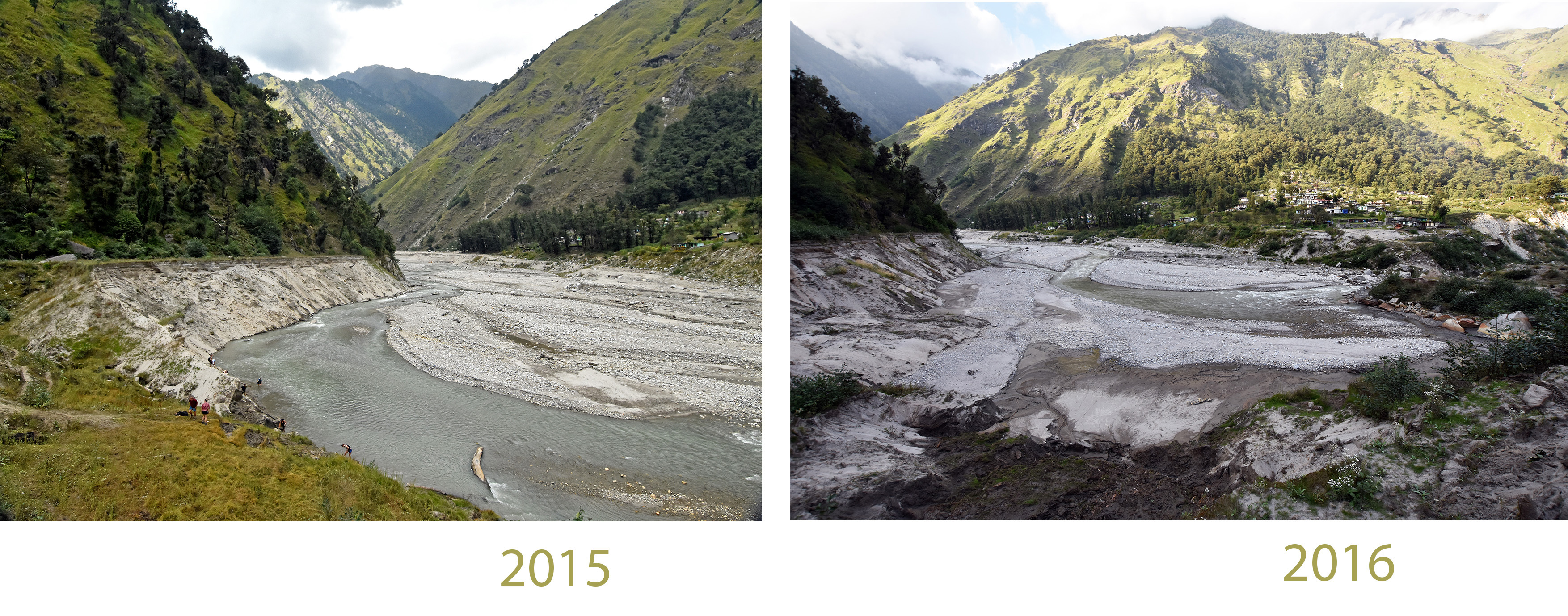
The Umachiya river drains into lower Darma Valley from the west. It is a small, steep catchment. During the downpour of June 14-17, a torrent of rock was borne down the Umachiya, past the village of Tejam, to enter Darma Valley just upstream from Sobla village. Much of the rocky debris originated from a meadow alongside Tejam, which was radically excavated during the storm. Whenthis rock flow reached the main stem river of the Darma Valley, it reshaped the channel, destroying a road, burying the Sobla village and swamping a reservoir.While Sobla was almost completely buried, most of its residents survived because they had gone to the high mountains to collect Cordyceps caterpillar fungus to sell to China. Further on, the flood surge, arguably intensified by mismanagement of the reservoir, entered the Mahakali river, which was already raging, and contributed to the partial destruction of the town of Darchula. Most of the damage was on the Nepal side of the Mahakali.
Umachiya river at its Darma valley confluence. Our 2010 campsite is just visible in front of the house. All of this infrastructure was destroyed in 2013.
The Umachiya river confluence in Darma valley. Sobla village is on the right bank of the Dhauliganga, downstream and just visible in the 2010 image. In 2013 Sobla was destroyed by floodwaters and buried in boulders that probably came down from Tejam.
The devastating rain of June 2013 was not a seasonal phenomenon. It was a westerly storm, swept in by the same atmospheric circulation patterns thatnormally bring heavy winter snow to Kashmir and the Karakoram mountains, several hundred kilometers further north. Like a California ‘Pineapple Express,’ this event incorporated humid air from the Tropics, borne northwestward at the onset of the monsoon. To a rough approximation, Uttarakhand experienceda full frontal storm with layered airflow, but one that came late enough in the spring and far enough south to tap water vapor from the incipient monsoon, which was massing on schedule over the Bay of Bengal and moving westward across the plains of northern India.
Meteorology
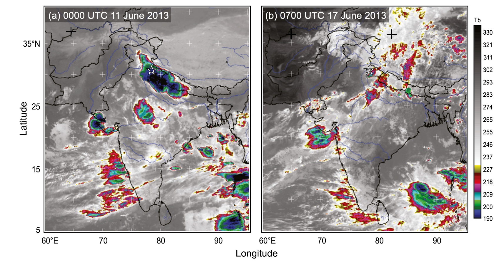
Robert Houze and his colleagues at the University of Washington provide a lucid analysis of the meteorology that brought all the rain to Uttarakhand in June 2013.
Powerful thunderstorms soaked Uttarakhand with 40-50 cm of rain on June 10-11. This event, shown on the left, has cloud tops that are relatively cold (shaded blue) because they have slammed all the way up against the tropopause layer, eight miles high. The more sustained event that caused flooding on June 14-17, shown on the right, has stratiform clouds that are warmer(shaded red) because they are not so high in the atmosphere. The scale on the right is cloud temperature in Kelvin. From Houze et al., 2017.
Seasonally, in winter, winds from the Mediterranean blow across Iran and the Caucasus mountains, bringing snow to the northwestern part of the Himalayan Arc. These westerly storms transport layers of humid air that ripple through the upper atmosphere, dropping heavy precipitation on Kashmir and Baltistan in the northwest Himalaya and Karakoram ranges. When thewesterly storms cross the mountains, they generate heavy precipitation, but they are conservative in their expenditure of heat energy, unlike the boisterous convective storms of the summer monsoon, which inject heat energy into the upper atmosphere in a turbulent and explosive way, discharging gigavolts of electricity and condensing rainfall vigorously. That churning thunderhead on the afternoon horizon, a convecting cell of heat energy, might well be regarded as the currency of the monsoon. Energetic as it is, a monsoon convective cell is highly unstable and will dissipate in a matter of hours. Westerly storms play out on fronts that can be hundreds of miles long and last for days, tapping into an atmospheric plume of moisture drawn from far away.
Westerlies happen further north, in winter. The monsoon prevails further south, in summer, so normally the two kinds of storms don’t meet. In 2013, however, westerly winds veered southwards to cross the Himalaya in Uttarakhand, India just as the seasonal monsoon began to fetch humid air from the Indian Ocean. When these two systems joined, they generated a frontal storm that bore an exceptional amount of moisture.
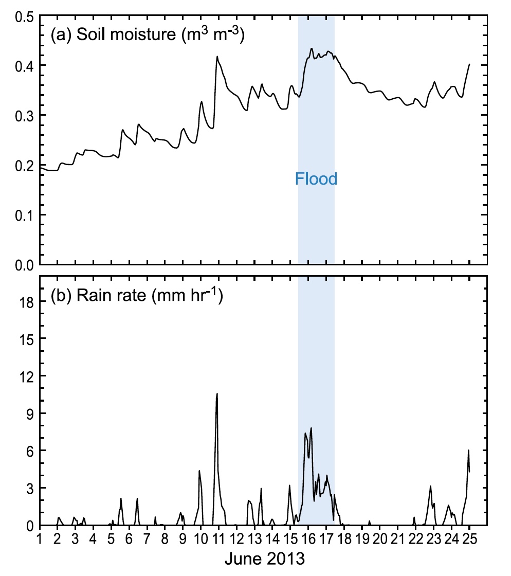
Houze et al., 2017. Figure 7. Floods happen when soils that are already soaked receive heavy rain.
The big rain on June 14-17 was especially destructive because it happened immediately after strong convective storms (June 11-13) that saturated the seasonally dry soils with several hundred millimeters or rain. Landslide-enabling levels of soil saturation were already extant in Kumaon even before the big storm hit.
After the westerly current crossed the Uttarakhand Himalaya, it brought blizzard conditions to arid parts of Tibet. Holy Mt. Kailash got heavy snow at 5000 m elevation, causing much distress topilgrims who were trying to circumambulate the mountain. On June 15, I happened to be in Dunhuang, a Silk Road oasis town in the Hexi Corridor between northeastern Tibet and the Gobi Desert. Here, soaking rain fell onto the sand dunes for much of the day, part of a storm pulse that would drop 30 mm of rain, more Dunhuang normally receives in an entire year.
The Excavation of Tejam Meadow
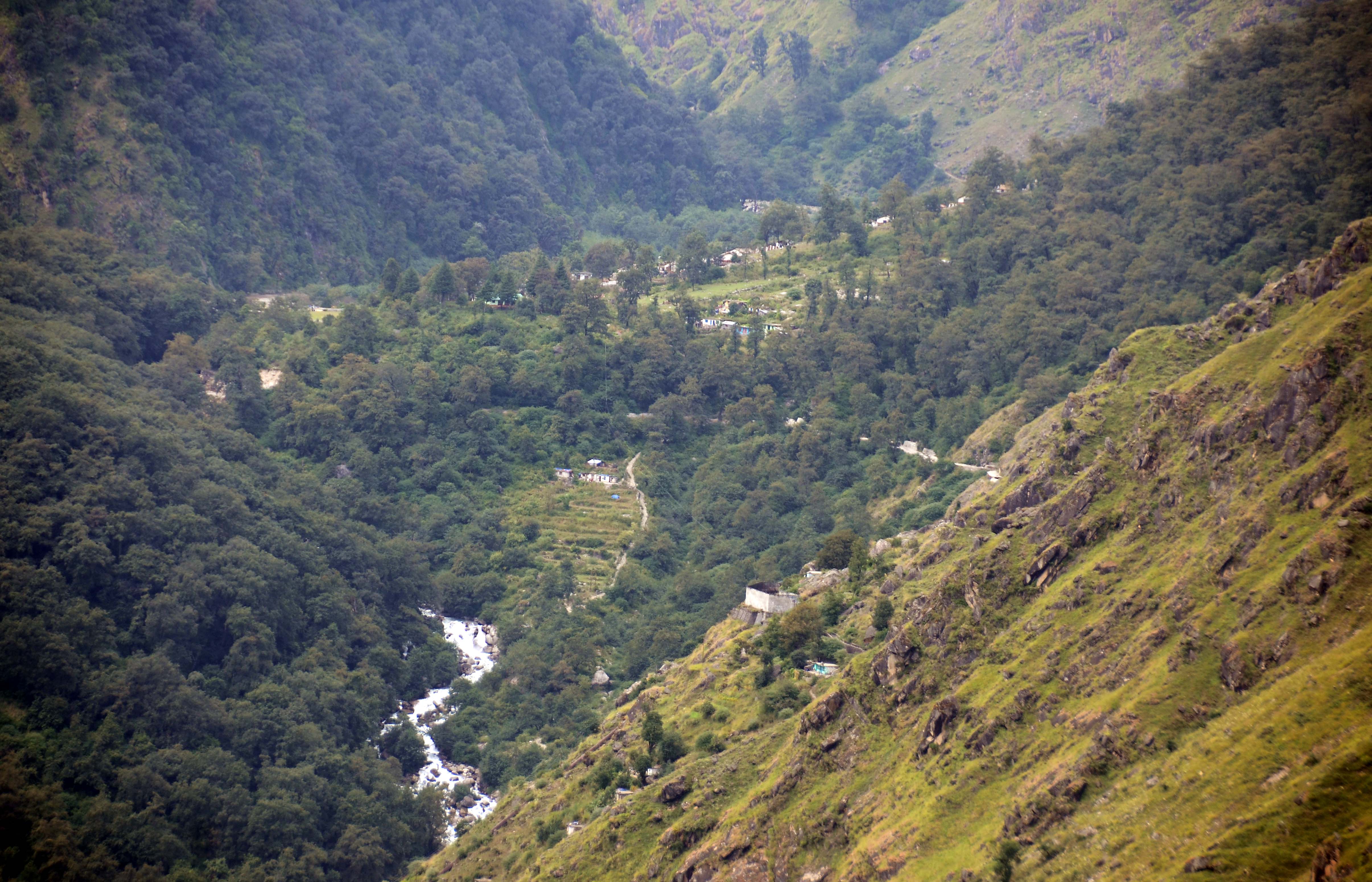
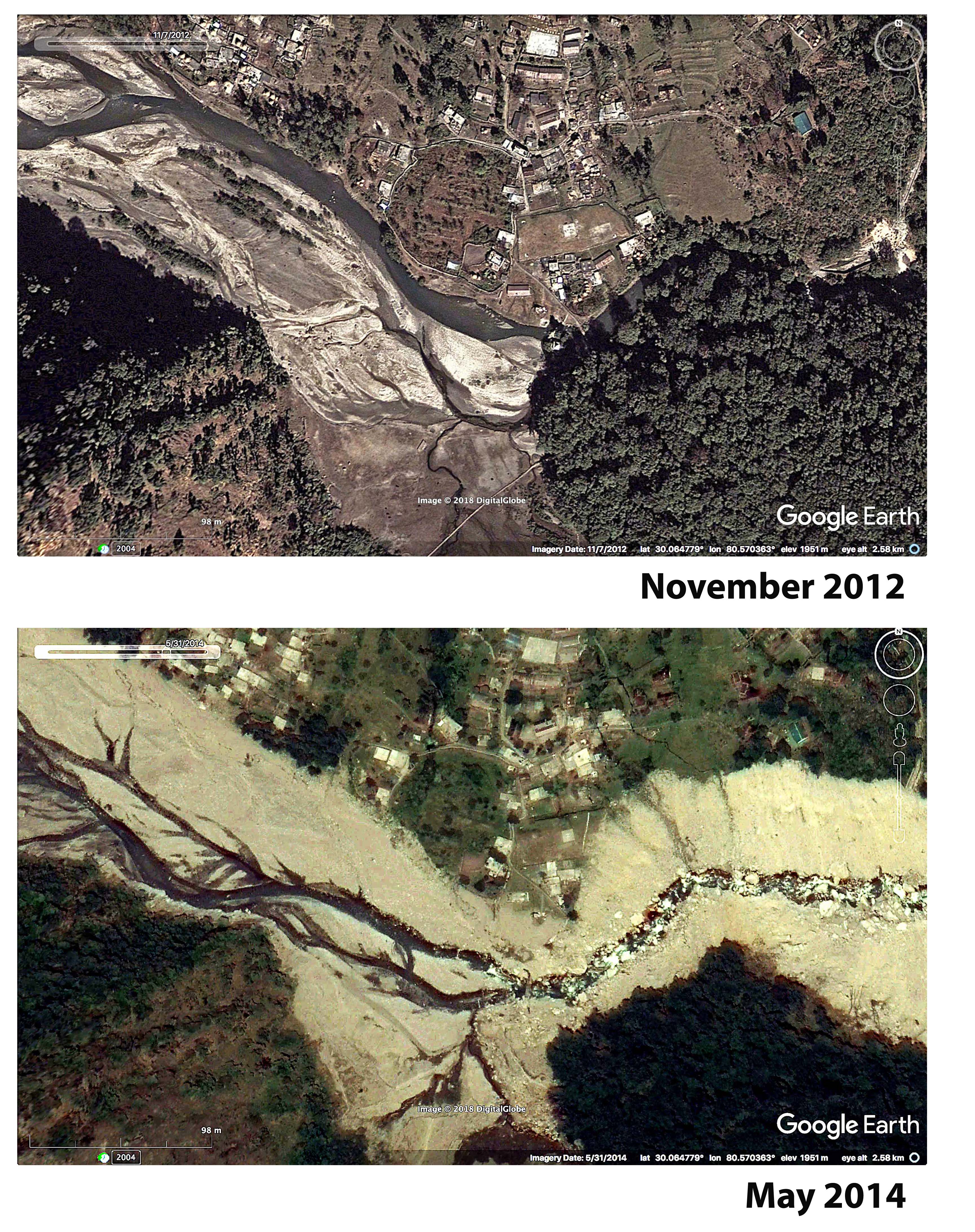
A telephoto view of the Umachiya river valley showing Tejam village, three years before the catastrophic flood. Dense forest in the lower left of this image covers landslide debris that came down and blocked the valley a century ago, or earlier.
Looking towards Tejam village, before and after the 2013 flood catastrophe. Flood waters broke a landslide dam at the lower end of the sandy aggradation plain and the river level dropped 10-15 meters, excavating the meadow. Evacuated material swept down the lower part of Darma Valley, destroying the village of Sobla, before entering the main stem of the Mahakali River.
The meadow across from Tejam Village used to be the biggest, flattest camping ground in the lower Darma Valley. Generations — perhaps a century — ago a landslide, medium-sized by Himalayan standards, came down opposite where the village is today. One imagines how, in a grinding roar and a cloud of pulverized rock dust, this slope failure it blocked the valley, impounding the stream to form a lake, and how over decades the lake filled with sediment to produce the landscape we saw in 2012, a broad sandy meadow covered in grass (or small plants that look like enough like grass that it doesn’t matter) and a braided river channel so shallow that you had to lie down to bathe. Today the landslide’s terminal debris pile is covered with hulking alder trees, more or less uniform in size. Since Himalayan alder is a pioneering species on landslides, perhaps this cohort of trees marks its age. In 2012, after passing the landslide and leaving the meadow, the Umachiya river plunged through boulders, dropping 250 meters to enter Darma valley’s main river, the Dhauliganga.
In short, in 2012, Tejam meadow was an iconic example of the sort of aggraded landscape that develops as the consequence of a valley-blocking landslide, as Kenneth Hewitt has described so well.
Here’s a satellite view of Tejam before and after the 2013 flood. 2012: Note the alder trees pioneering rocky furrows near the river while the camping area (bottom center) has only grassy vegetation, because it is poorly drained. An elevated rock path crosses the boggy meadow. The expanse between the camping area and the army camp (center) is flat with ephemeral braided stream channels. 2014: The dam has broken and millions of cubic meters of rock have poured out, removing most of the meadow and lowering the level of the valley by 10-15 m. A remnant of the meadow large enough to camp on remains, visible in the bottom center of the 2014 image.
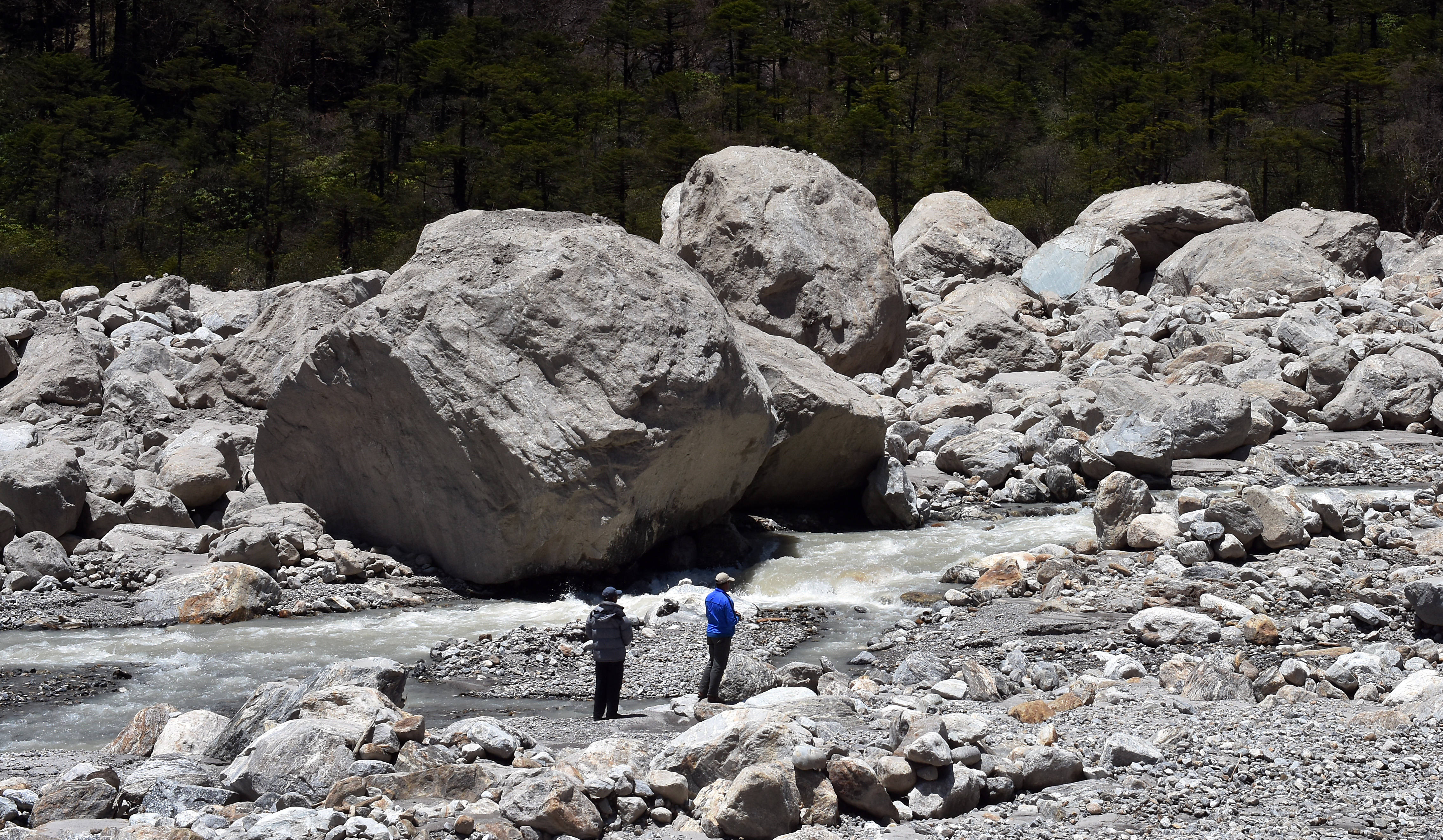
This landscape was altered profoundly by the flood in 2013. The flood waters and the rock they transported incised a channel through the dam, and the then, accelerated by its new, steeper pitch, the river cut swiftly headward, washing out what I estimate to be about 3 million cubic meters of impounded sand and rocky debris. This washed down into the Dauliganga river, retooling the confluence, burying Sobla village and contributing to the destruction further downstream.
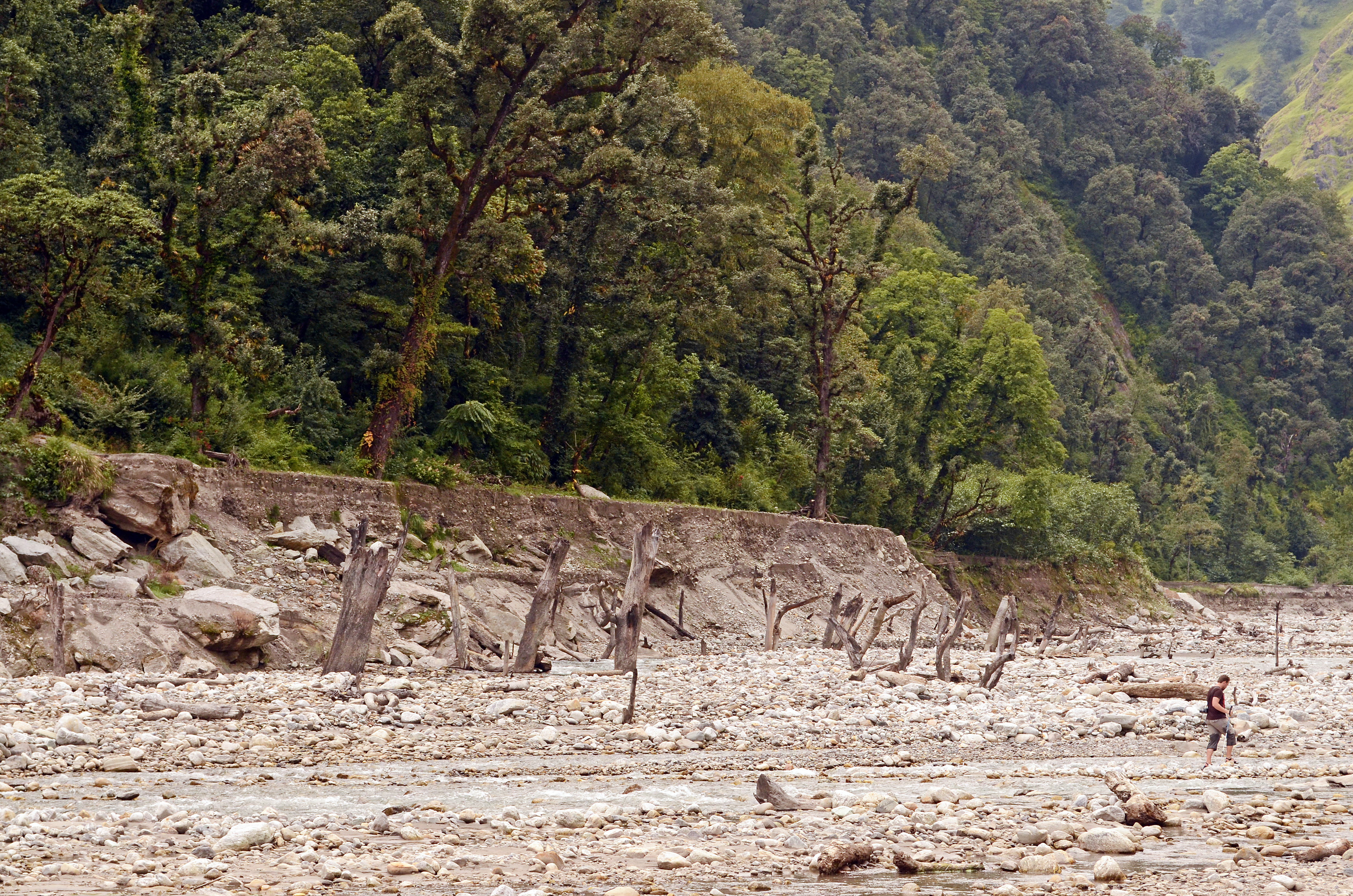
When we returned to Tejam in October 2014, we saw that the landslide dam at the foot of Tejam meadow had been truncated in a spectacular fashion and that most of the meadow was gone, explaining the likely origin of the rock the buried Sobla. Where the meadow had been was a rock-bound, flat-bottomed gully that held the Umachiya river at an elevation 15 m lower than it had been two years before. Upstream, sheer valley walls were exposed. Closer to the old landslide dam, remnants of the meadow still held.
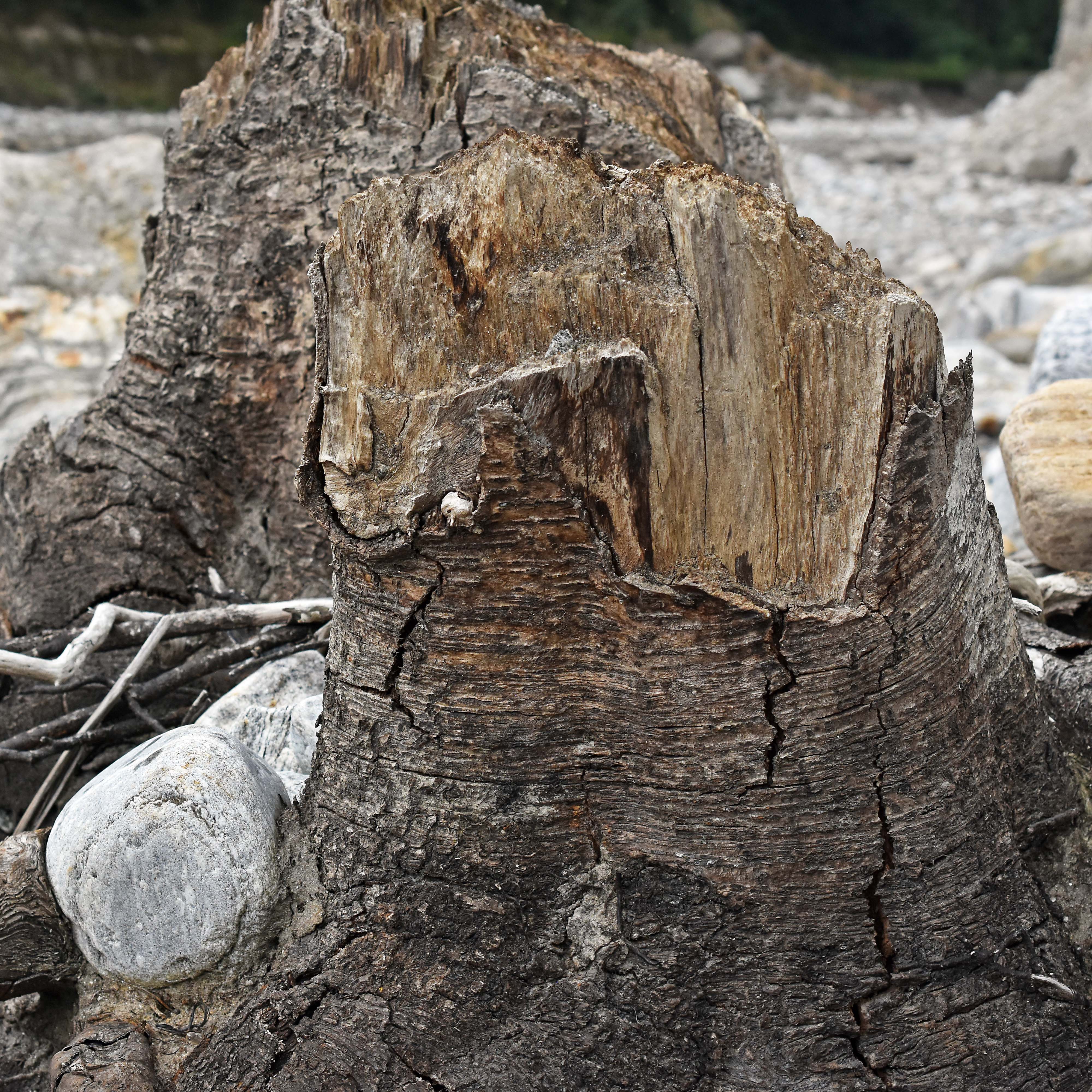
In the upper reaches of the excavated meadow, there had been less infilling and here the standing trunks of old trees, drowned after the landslide and then buried during aggradation of lake to meadow, had been recently exposed. One specimen could be recognized as a birch, others as alder; some might have oak, which are abundant on nearby stable slopes.
These newly excavated tree trunks might have been alder, or they might have been oaks like the live trees behind them.
Old tree trunks that had been buried during the aggradation of a landslide-formed lake were exposed after the 2013 flood. We see Alnus alder, Betula birch and Quercus oak.
How long ago was this Himalayan alder drowned then buried?
In the post-flood years, 2014-2016, the terrace where we camped continued to change. Erosion ate away the terrace along a sandy slope, with steep-sided ravines cutting inward. And, as the water table dropped, vegetation changes from a sandy plain sparsely covered by grasslike plants to a more woody habitat with various borages (sky blue flowers and obnoxious seeds) and young alder responding favorably to the airy soils.
Basically, Tejam meadow illustrates the entire cycle of instantaneous slope failure and dam formation, rapid lake filling, gradual aggradation from lake to plain, and then destruction of the plain in an episode of rapid incision and headward erosion that Kenneth Hewitt describes for tributaries of the Indus river. Tejam differs from the places Hewitt has studied because it is much wetter, giving it a different flood regime and vegetation dynamics, and because it is relatively small. The Tejam landslide might have moved five million cubic meters of rock; the minimum size for a landslide to be included in Hewitt’s Karakoram is twenty times that volume.
Like many streamside meadows, Tejam couldn’t drain easily because it sat at the level of the water table. Soils, waterlogged for months on end, maintained an arrested state of ecological succession where grassy species prevailed over the shrubs and trees that would replace them in airier soils.
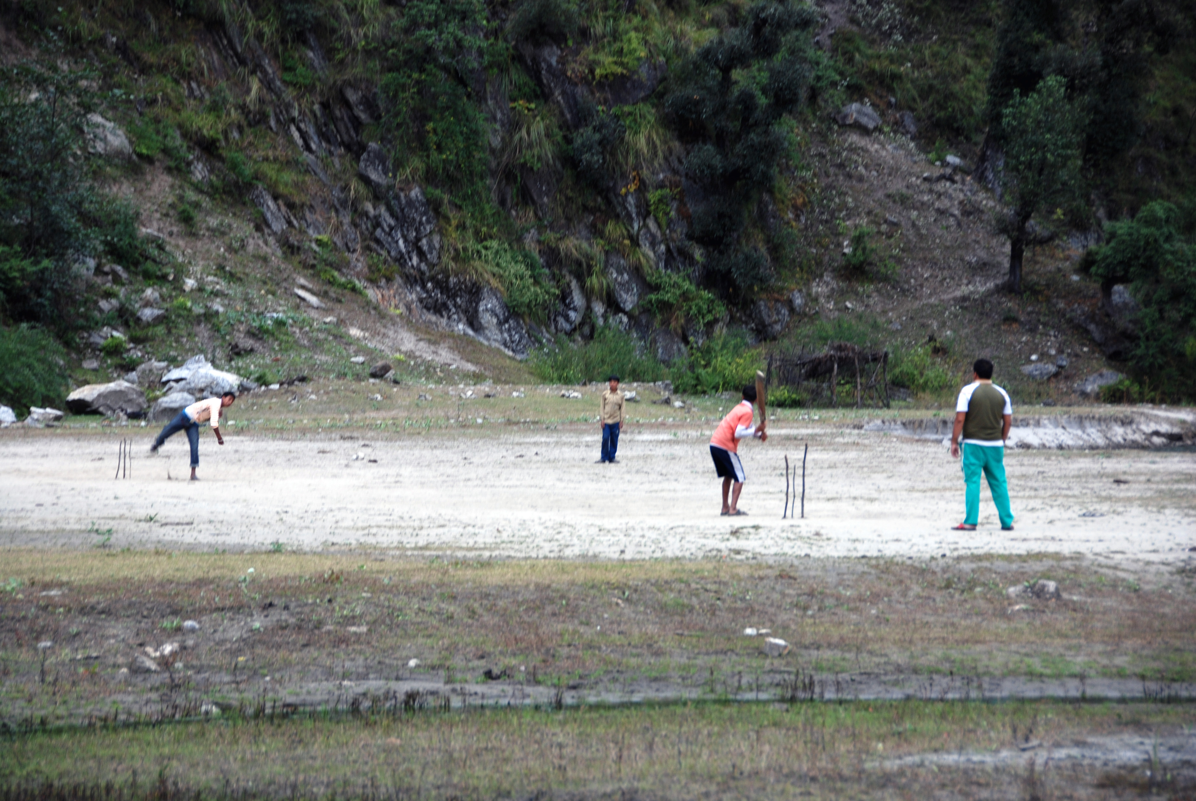
Cricket at Tejam Camp, October 2010. By 2014, our camping area was no longer suitable for cricket, and the crossing from Tejam had become an annoying, muddy clamber. Thieves who robbed our camp in 2015 exploited this ‘friction of terrain.’
The edge of our campsite, opposite Tejam village, in 2015. Every monsoon the slope retreats, narrowing the terrace, even as alder saplings are growing rapidly to stabilize it. Oak trees on the slope in the distance are skinny as bean poles because they have been lopped for fodder to feed livestock. People may snap alder twigs for cooking fuel, but their leaves, much eaten by insects, are not suitable livestock fodder.
After the meadow was lost and the river dropped, the water table on the remaining meadow terraces dropped as well, providing fresh air to the roots of young alder that responded with vigorous growth. By fall 2016, there were only traces of the meadow, dissected by gullies and separated from the river by a wet, crumbling escarpment of sand and partially decayed plant material that created a rank, unwholesome milieu. Trails to the meadow, disused now, are being overgrown with pioneer species like stinging nettle and borages whose seeds implant themselves permanently in fur, socks and bootlaces.
Up valley from the Tejam campsite. Year by year, sediments fall away from the remnants of Tejam meadow, especially on the outer bend of the river (left in the photo). Those debris washed away since 2015 appear to hold more organic material — gunk on the eroding slope, oozing down towards the main channel.
The Sense of Alder
The tree called Himalayan Alder (Alnus nepalensis) is germane to catastrophic erosion in the Himalaya because it is the number one pioneer and stabilizer of slopes that fail at a wide range of elevations including most of the elevations where people live. Here in Tejam, the lobe of rocky landslide debris that held back the meadow until it was cut in 2013 supports a magnificent forest of Himalayan alder. The trees are mature and appear to be about a century old, maybe more. Like other pioneering plant species, a Himalayan alder tree maximizes reproductive fitness in an uncertain world by producing copious wind-borne pollen and potentially great numbers of nutlets, tiny seeds about 2 mm long with membranous wings that disperse in the wind so uniformly that when gravity pulverizes an expanse of bedrock, or the river deposits a fresh terrace, alder babies seem to erupt spontaneously from the damp sand and mica.
Himalayan alder, with the help of symbiotic root bacteria, can take nitrogen gas from the air and ‘fix’ it, which means putting the nitrogen atom together with hydrogen or oxygen to make chemical compounds essential to growth. In this way, Himalayan alder is less reliant on the nitrogenous waste of other organisms: self-sufficiency is useful to pioneers.
When we visited Tejam in 2012, those big alders on the landslide lobe made an attractive backdrop for our campsite, as well as a backstop holding in place the meadow we camped on. The lower part of the meadow, backed up against the old landslide, could not drain well, so it had grasses, but no trees. Young alder were testing the margins.
Mature Himalayan alder, growing on landslide debris, release pollen on the valley winds. A younger cohort of alder, visible at the bottom of this image, fringes the meadow. October 2012.
Fixing nitrogen with the help of bacteria in its root nodules, Himalayan alder colonizes fresh landslide tailings with speed and panache (October 2015)
This mature stand of Himalayan alder may be the original pioneering cohort on the landslide that made Tejam a meadow. Note the understory of stinging nettle.
The Tejam Villagers
Tejam is one of the higher villages in Darma Valley that is inhabited year-round. Residents of the Darma Valley, who refer to themselves as Rung, have a trans-Himalayan ancestry. Today they identify Hindu, but their genetic heritage and cultural traits show an affinity with Tibet. A couple of generations ago, the Rung were accorded Scheduled Tribe status, providing opportunities for higher education and government service that has encouraged them to steer away from traditional livelihoods. Catastrophes like the 2013 flood must further demote the appeal of traditional livelihoods to the next generation of Rung.
Rung people have a history of transhumance, spending the warm part of the year in high valleys where they grow buckwheat and graze livestock, and over wintering in the Mahakali river valley. Various pressures make this lifestyle problematical for the next generation of Rung people, but people from the Mahakali Valley do seem to value their summers at high elevation. Road construction to the highest inhabited elevations of Darma Valley threatens to be a big disrupter of local traditions, but the road is popular nonetheless because it means visits to the summer village can be shorter and more frequent.
Later I want to write about some interesting places in the upper Darma Valley, including the high elevation byaksi, tributary valleys that hold tremendous scenic and religious importance to the local people.
Photo credit Maria Vishnevskiy
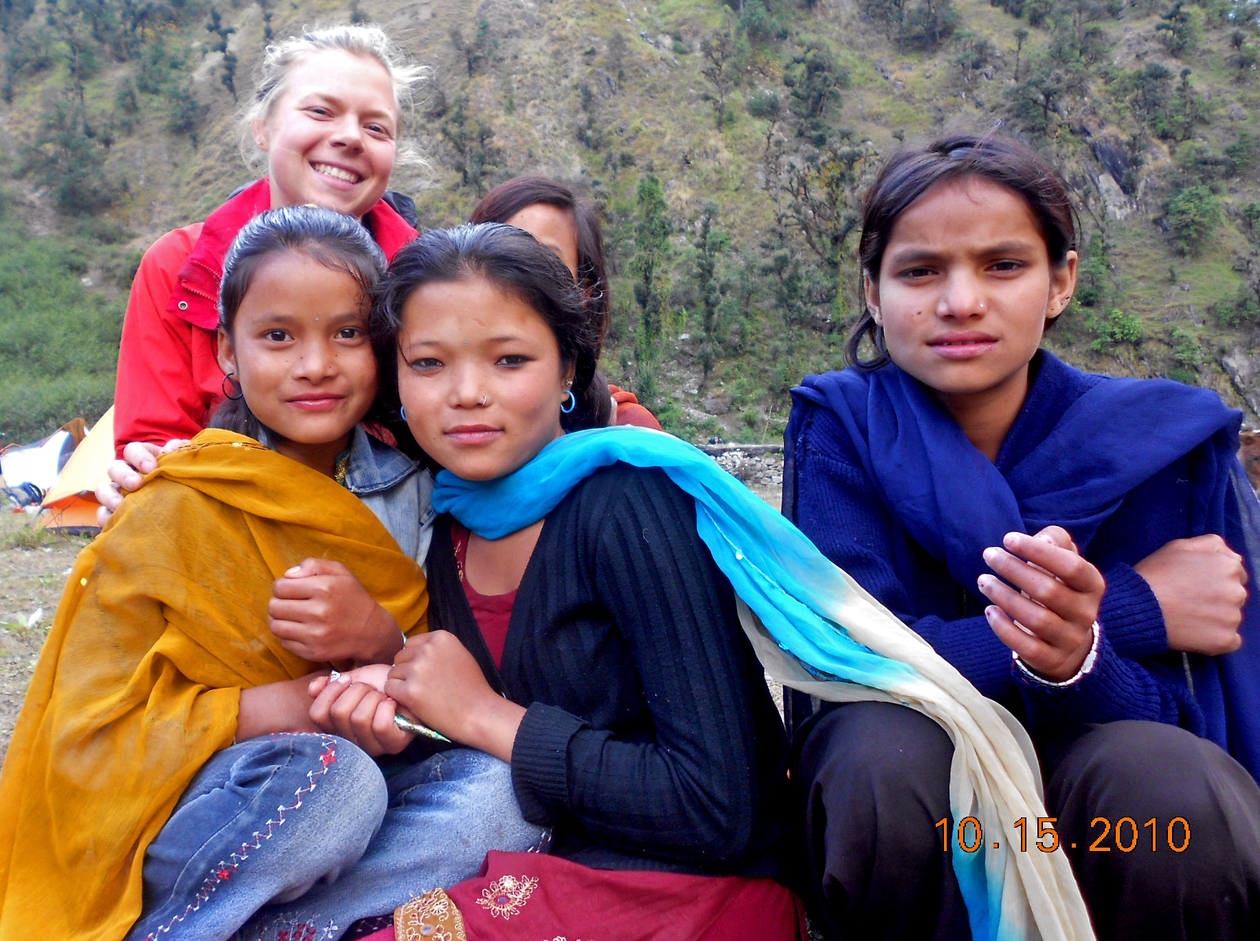
Tejam kids with Wildlands students in 2010 and 2012. Before June 2013, it was easy to cross from Tejam village to our campsite, so the kids often came over to check us out.
After the landslide, access to Tejam became more complicated. In 2014, the best way to get from Darma Valley to Tejam was to follow this irrigation canal, which during the post-monsoon meant scampering through a waterfall.
I am reposting this brilliant graphic from www.chiangmaiair.org because it illustrates a few points crucial for an effective campaign to clean the air in Chiangmai.
This image, from NASA’s Fire Information for Resource Management System (FIRMS), shows a high concentration of fires in northern Myanmar and northern Laos, substantially fewer in northern Thailand and southern China. The border between northern Thailand and its neighbors appears to demarcate fire density pretty well.
This image is from a day when Chiangmai had good air quality. But if the fire distribution shown here is typical of our burning season, then we are seeing a regional issue. This conforms to my experience of smoke in other parts of southern Asia at this time of year.
Perhaps we could offer the Chiangmai authorities some guarded praise for their work so far, and consider promoting solutions to the problem at a more regional (i.e ASEAN) level.
It would be interesting to consider a FIRMS time series for this area, and to review literature for references to seasonal smoke in previous generations, as it has likely been an outcome of paddy rice and swidden (slash and burn) agriculture in SE Asia for many generations.
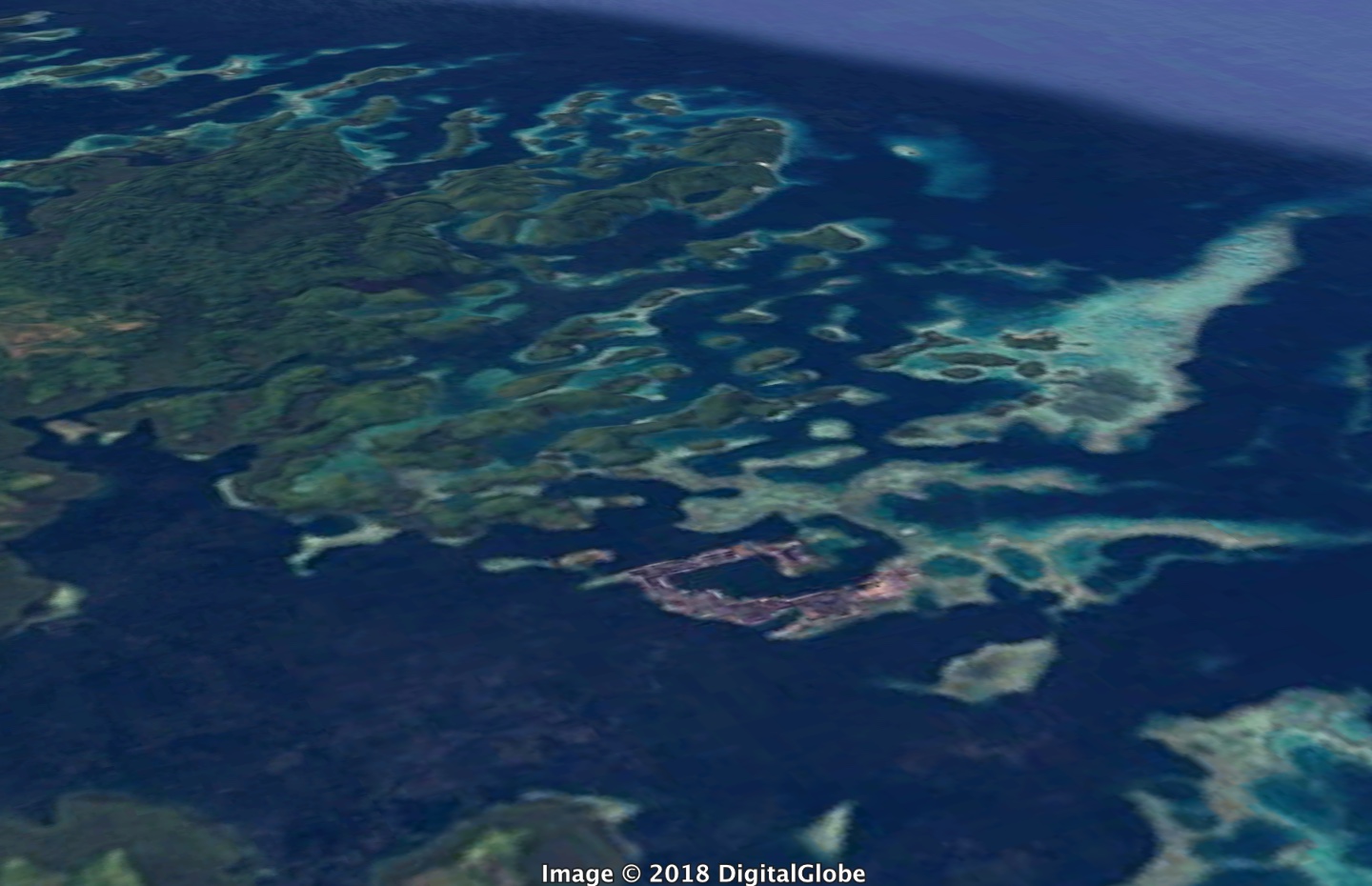
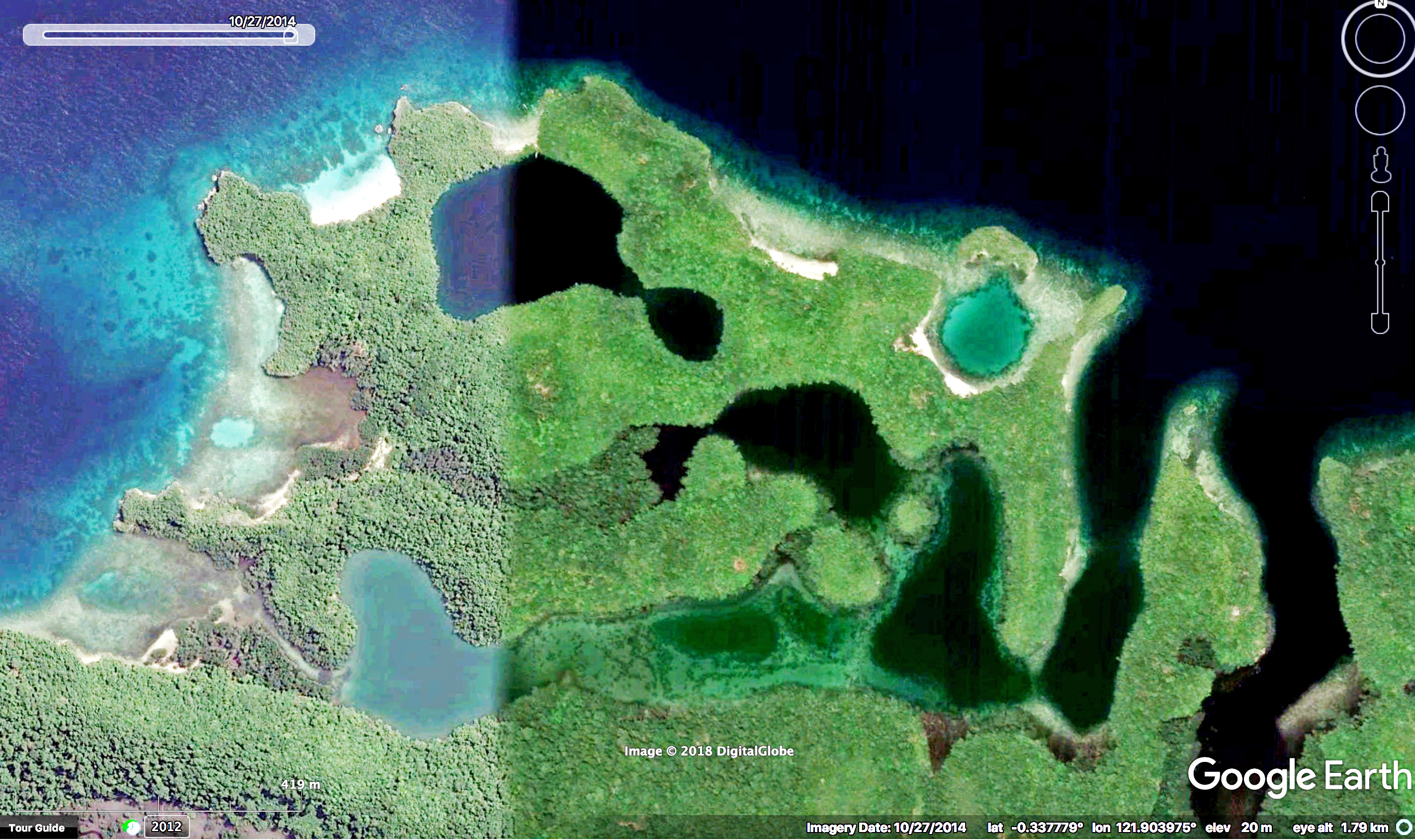
It appears that in the past ten thousand years or so, since the end of the Ice Age, sea levels have risen to inundate the coastline of the Togean Islands, but surrounding water of Tomini Bay are so calm that the inundated landforms remain largely intact.
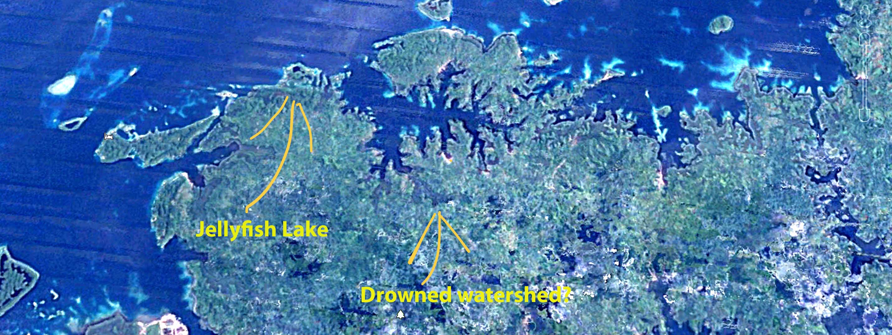
Kabalutan village and the southern margin of Tala Teoh Island rendered from satellite imagery in Google Earth. This half-drowned landscape belongs to the Luwuk Formation, coral-derived limestone that rose above sea level within the past two million years and now appears to be sinking again. It really looks like a coastal watershed that once drained southward (up and right in the photo) when sea levels were lower than they are now.
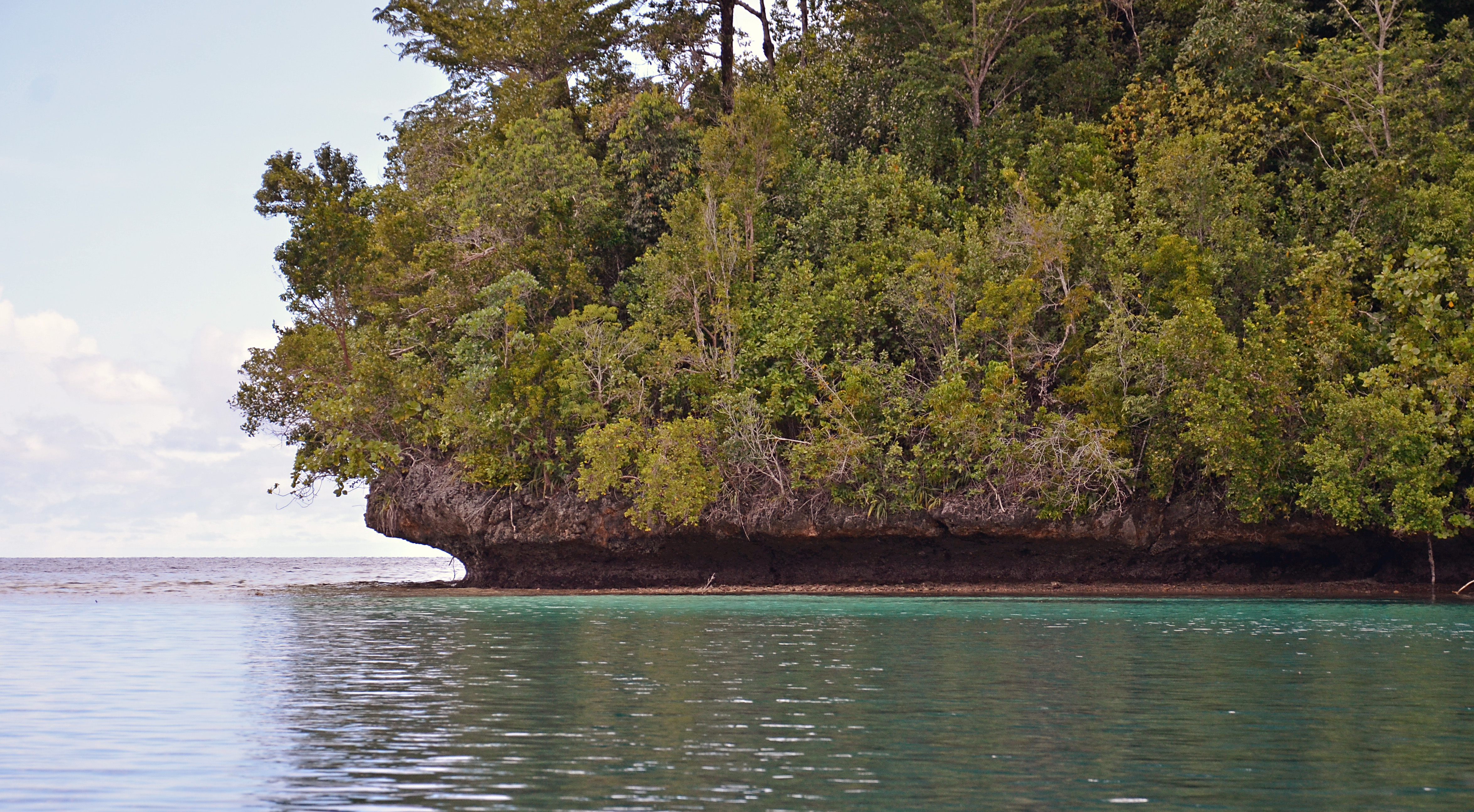
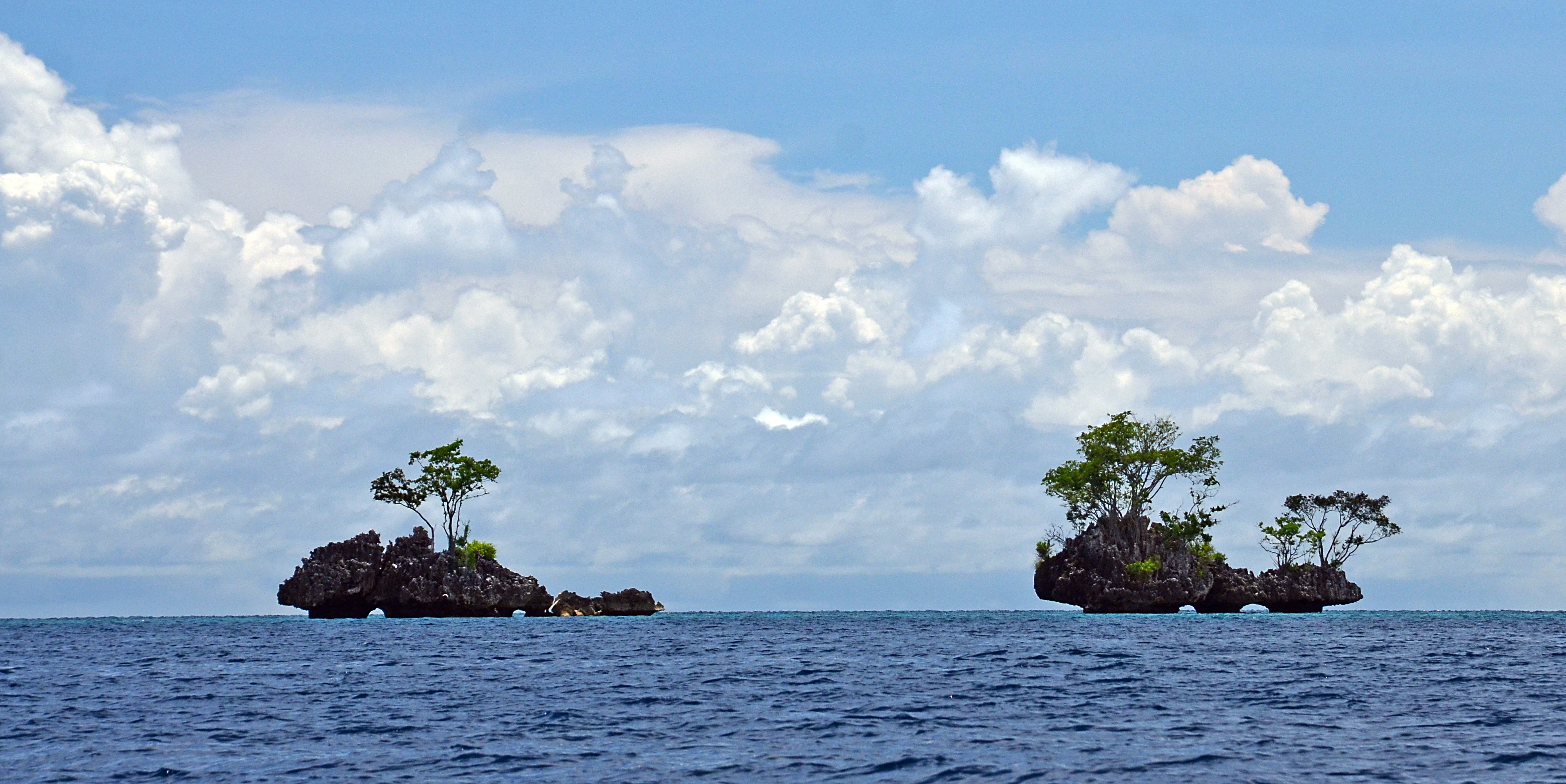
Much of the Togean Island shoreline is limestone, cropping up jaggedly about ten meters or so, sharply in-cut just above the high tide line. Like the limestone towers of southern Thailand, this calcium carbonate is biogenic: its crystal structure shows that it was precipitated from sea water by living organisms. However the creatures whose metabolic energy made the limestone of southern Thailand lived in Paleozoic time, more than 300 million years ago. The limestone of the Togean Islands is Quaternary, less than one per-cent as old.
Quaternary limestone crops up from the northwest shoreline of the Togean Islands. Undercutting looks like mechanical erosion from recent storms, but is more likely to result from millennia of scraping by intertidal animals like chitons that thrive were waters are usually calm. This undercutting might have happened some thousands of years ago when sea levels were higher than they are today.
A story of young limestone, formed from coral and raised a few meters above sea level, is compatible with the active tectonics of Sulawesi and Tomini Bay. This pattern occurs as well in other parts of Indonesia like Flores island, where limestone from Quaternary coral reefs has also hoisted above sea level. But the Togean Island shoreline, which rose above sea level in the past couple of million years, appears to have partially sunken again in the past few thousand.
Does this argue for a more recent, tectonically-driven subsidence? It’s possible that the land has subsided, but Holocene (post Ice Age) sea level rise is a more parsimonious explanation. During the Last Glacial Maximum (less than twenty thousand years ago), sea level was more than a hundred meters lower than it is now. A rise to modern levels would be just about right to explain the flooded drainages, the artificial-reservoir-like bays, and flooded dolines like Jellyfish Lake.
Five atoll-like platforms rise from deeper water a few kilometers off the northern edge of Malenge Island. The westernmost platform, called California Reef, is nearly exposed at low tide, the easternmost, Reef Five, is several meters below the surface. These are not true atolls, which are oceanic structures, but are probably low-lying surfaces that have submerged, eroded smooth and acquired a veneer of coral reef in Holocene times. The sides of California reef, too steep to support coral, may be composed of the Quaternary limestone, though it would be good to check that more carefully.
California Reef, reflected by calm surface waters, may be a submerged platform of Quaternary Limestone. It’s surface is less than a meter from the low tide level.
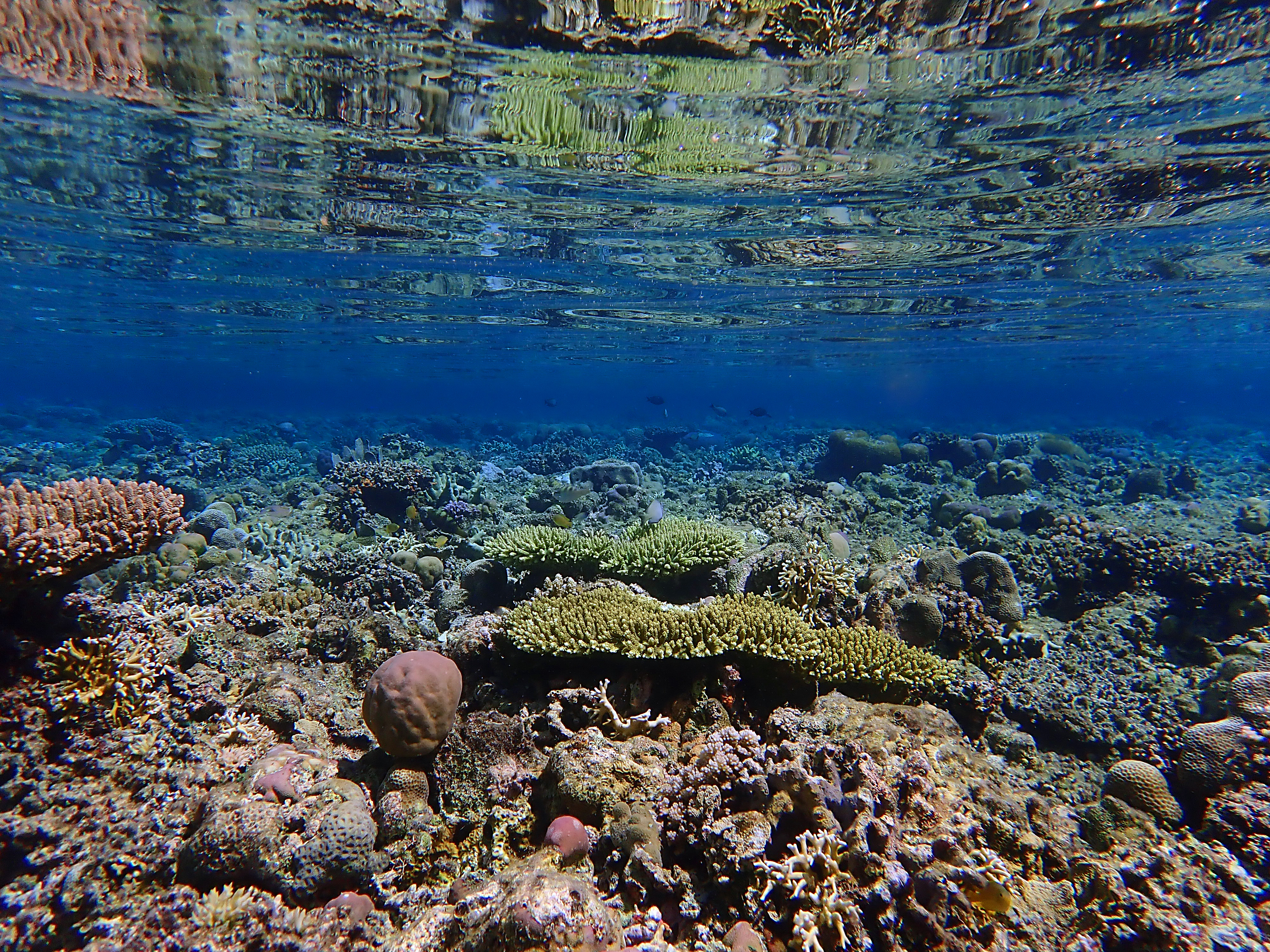
Reef Five, another submerged surface a couple of kilometers north of Malenge Island, lies several meters below the surface and supports beautiful colonies of tabletop Acropora branching coral.
As sea levels have risen over the past 12,000 years or so, pre-Holocene landforms have been inundated without having been destroyed by wave action. Tomini Bay, which surrounds the Togean Islands, is especially placid by oceanic standards for a couple of reasons. First, it lies almost exactly on the Equator, so it does not receive typhoons, which are bound to drift poleward as they strengthen. Second, Tomini Bay is sheltered by the northern and eastern peninsular arms of Sulawesi, offering a safe harbor not only from the waves of more distant storms, but from those of the seasonal trade winds that blow down from the East China Sea. Perhaps the sheltering arms of Sulawesi are explain how fragile topographic features like dolines and stream channels have survived intact along the shore of the Togean Islands, while they have been obliterated in other places like Peninsular Thailand. It more exposed locations, Holocene sea level rise would have been accompanied by higher wave energy that would have altered coastal features as they were inundated.
Light blue is the Luwuk Formation of Quaternary limestone, the contours of which have been preserved even as they sink into the sea. From: Hall, R., Cottam, M. A. &Wilson, M. E. J. (eds). 2011. The SE Asian Gateway: History and Tectonics of the Australia–Asia Collision. Geological Society, London, Special Publications, 355, 177–202. DOI: 10.1144/SP355.9 The Geological Society of London.
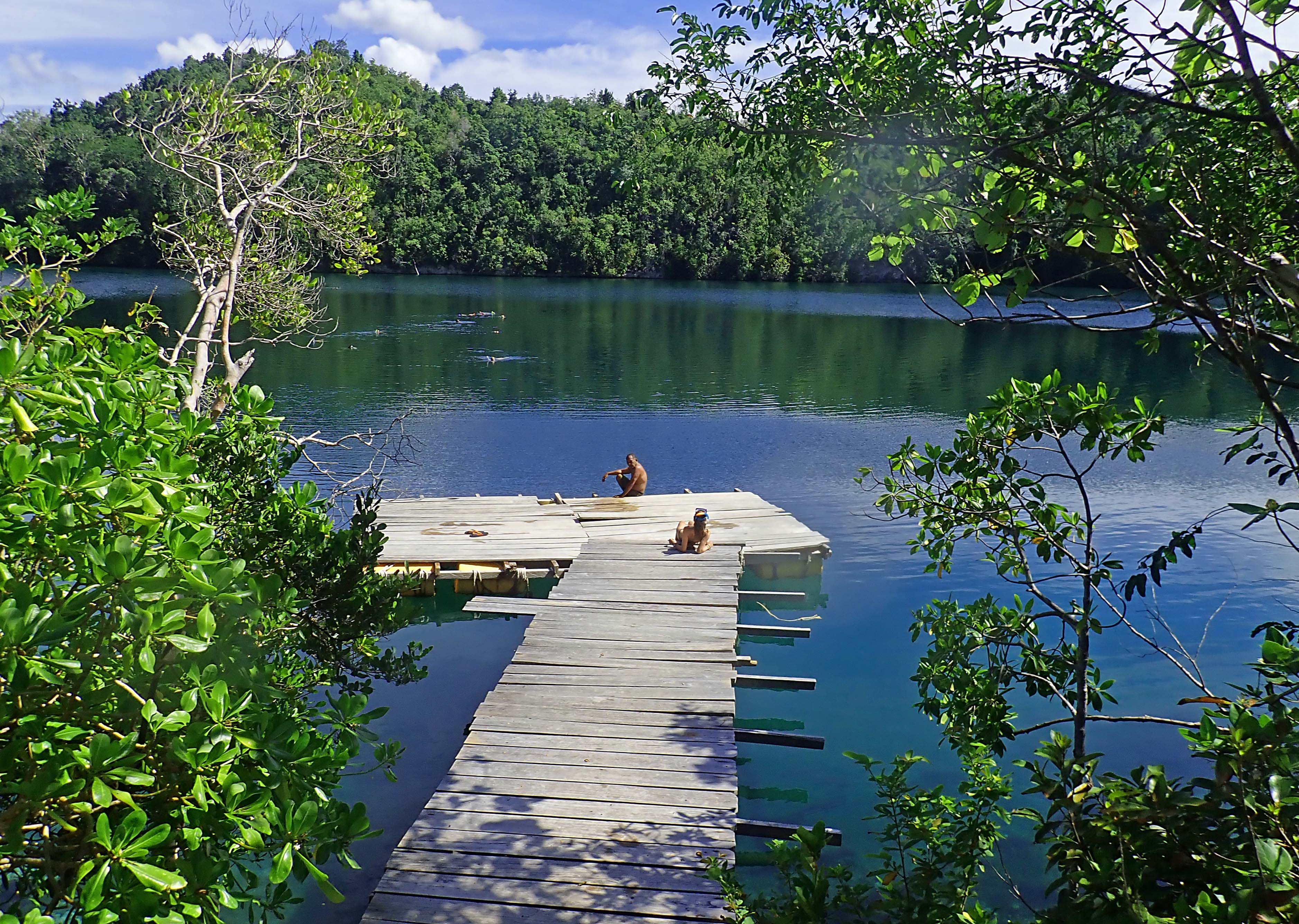
This article is about a marine lake in the Togean Islands of Indonesia, full of jellyfish that do not sting people. Here I muse about the how the lake formed, about its distinctive ecology, and how it fits into a narrative of ecosystem collapse without necessarily indicating collapse. Wildlands Studies, an academic partner of Western Washington University, enabled our team to visit Sulawesi in February 2018. Betchart Expeditions got me there in 2013 and 2016. To both of these organizations. I feel gratitude.
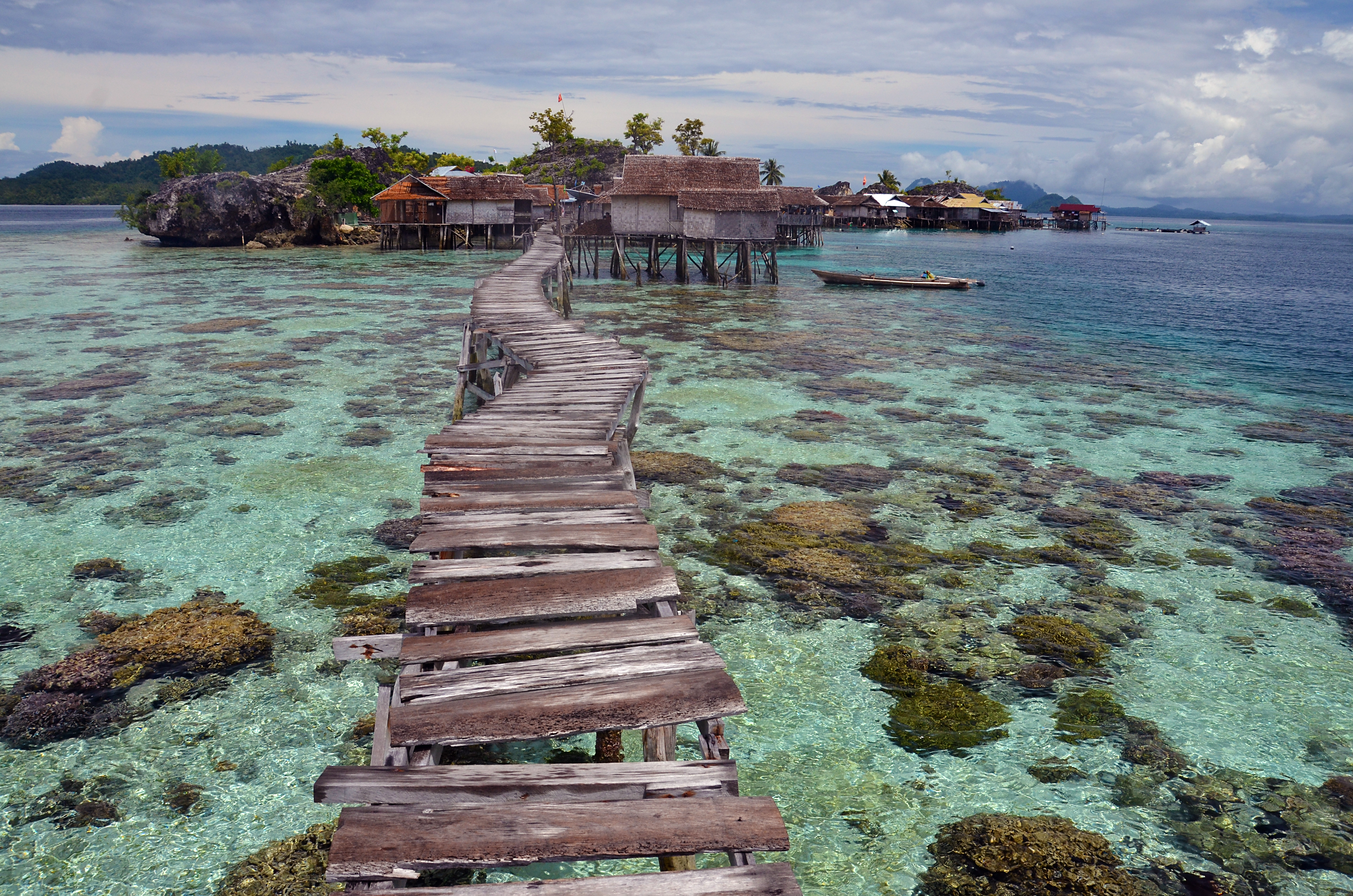
Equatorial magic along the arc of the Togean Islands, Pulau Papan in 2013. The plank walk has since been upgraded.
When the horizon is clear, the view from the Togean Islands includes two distant mountain ranges on opposite sides of Tomini Bay, one range to the north of the Equator, one to the south. Both belong to the Indonesian island of Sulawesi. Tomini Bay is about the size of Lake Superior, so the mountains are not near at hand, but they are very high and the air is clear in this sparsely populated, maritime realm. The waters of Tomini Bay are as deep as the mountains are tall and the bay itself is nearly encircled by Sulawesi’s long peninsular arms.
The Togean Island arc, seen from Tanjung Api on Sulawesi’s Eastern Peninsula, appears to hover above the horizon. Most likely, this mirage is happening because, following rain, the ocean is warmer than the air. My student Rachel observed that the water in Tomini Bay feels like butter.
Like much of the Indonesian Archipelago, the ocean basins around Sulawesi are tectonically active. Una Una, the volcano in Tomini Bay, erupted hard in 1983, and its ragged, truncated profile suggests that it might have blown sky-high in prehistoric times. Such explosive tectonics follow great rumblings of magma deep in the crust of the earth, which can cause the sea floor to rise or subside.
Evidently, in Quaternary times (less than two million years ago) the Togean Islands’ northern margin rose from the sea as a shelf of coral-derived limestone that dissolved slowly in the mildly acidic tropical rainwater. Much later, perhaps only tens of thousands of years ago, the sea reclaimed some of this upthrust coral, either because the formation subsided again, or simply because sea levels have risen over that time. It is not evident from a boat, but in an aerial perspective, the Togean shoreline looks like the flooded watershed of a reservoir, artificially dammed.
Limestone in the northern part of the Togean Islands is derived from corals that thrust above sea level in Pleistocene times. Undercutting visible a couple of meters of the waterline may result from abrasion by chitons and other marine creatures that thrive where the water is calm most of the time. Higher up, it has been dissolved by rain water and organic acids from plants (chemical erosion).
Bays along the northern shore of Togean Island display the outline of an artificial reservoir, signaling a flooded watershed. Is it tectonic subsidence, or Holocene sea level rise? Image Google Earth.
The case in point that matters here: a few meters inland, adjacent to a sandy cove called Karina, there is a flooded doline, or sinkhole. This concavity formed by chemical erosion when the limestone was higher than it is now. Since then, the sea has reclaimed the doline to form a marine lake, nearly a square kilometer in size, that appears completely isolated from the ocean, but which must be linked by one or more submarine channels big enough to admit small schools of rabbitfish and other denizens of the coral reefs outside.
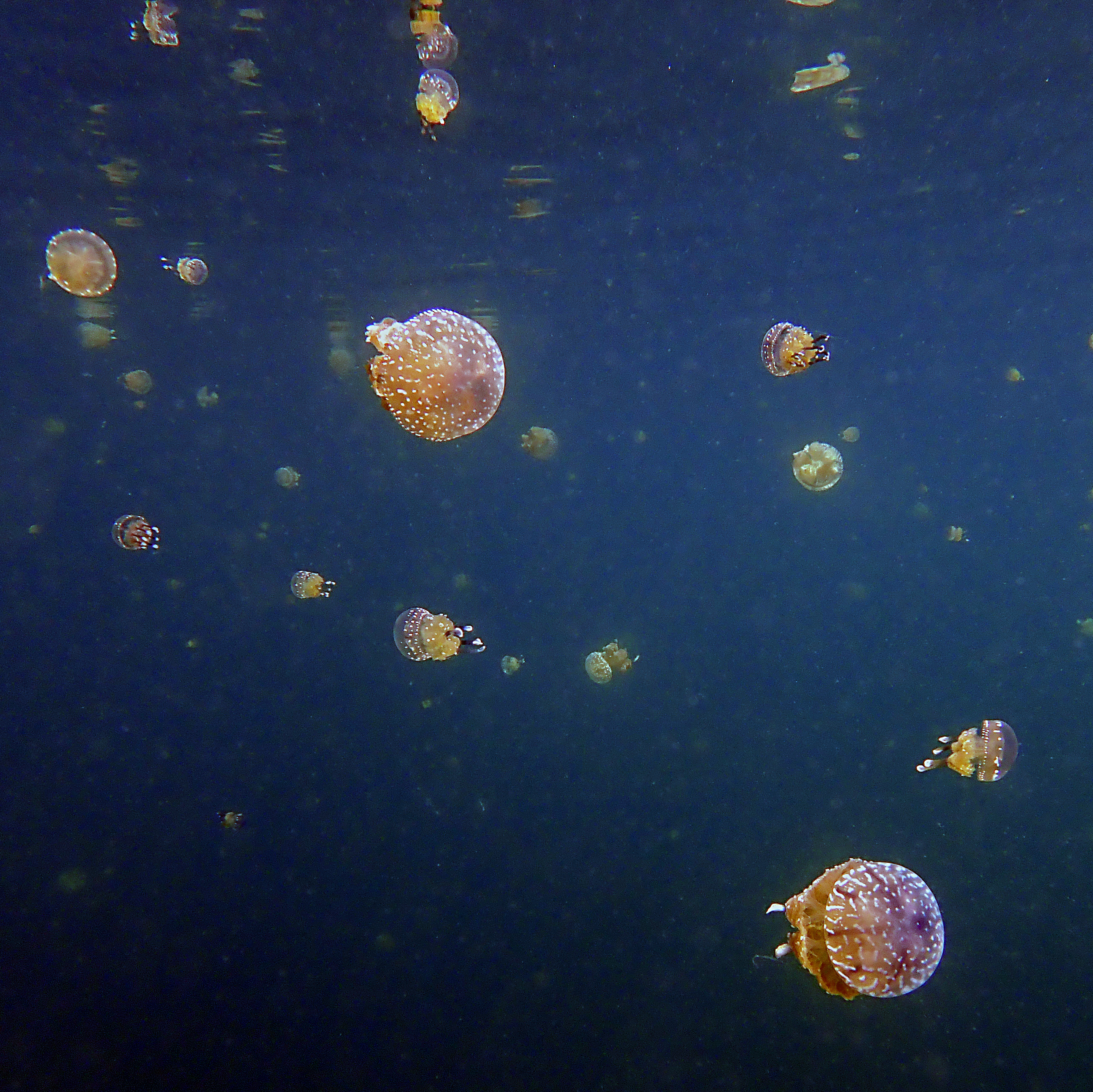
The hourglass shaped lake at the top of this image, a sunken doline, must have submarine connections to the sea big enough for rabbitfish to swim through. The lake is much warmer than the ocean. It holds two species of jellyfish and lots of sponges and holothurians you won’t see on the adjacent coral reefs.
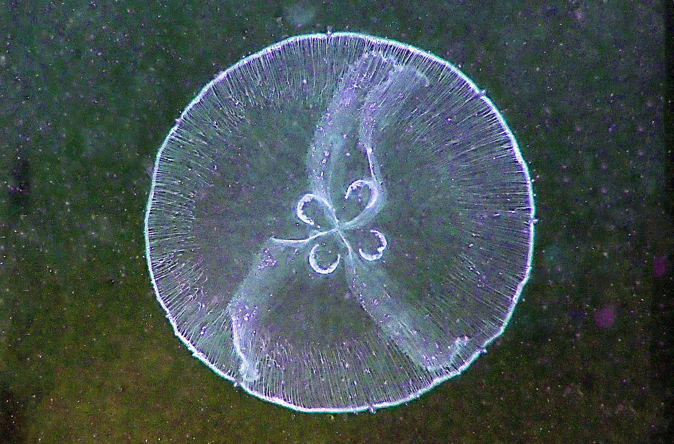
Water temperatures in the lake fall just shy of hot, perhaps in the mid-30° range Celsius. Near the forest-shaded margin, lake waters are clear, but they tinge green with phytoplankton out towards the middle where it is sunnier. The jellyfish appear a few meters offshore and become more abundant further towards the middle of the lake. After swimming a few meters, I see the colorless disk of a moon jelly (genus Aurelia) a couple of meters below. Higher in the water column and much more abundant are white-spotted jellies (Phyllorhiza punctata). Neither species is rare, and it is not the case that this lake has evolved a stingless kind: both species hold venom, but neither can deploy with enough force to penetrate any but the most delicate of human tissues. This makes evolutionary sense: potent, predatory venom-harpoons would be a needless burden for filter feeding plankton-eaters.
Aurelia, the Moon Jelly, is one of two (almost) stingless species of jellyfish in the marine lake on Togean Island.
Phyllorhiza punctata, White-Spotted Jelly, is most abundant in Jellyfish Doline.
The jellies pulsate rhythmically all the time, moving themselves along in the aboral (bell-facing) direction, although the particular trajectory does not seem to matter to the animal. Bell size governs tempo. Big ones, the size of a human heart, beat like the heart of an athlete, the little ones flutter adorably. These animals are reputed to move towards sunlight, to aggregate in groups. But today, from our perspective, swimming amongst them un-finned, they seem innocent of any tendency to orient themselves.
Aurelia, the Moon Jelly, is distinguished by four horseshoe-shaped gonads. It is a lethargic plankton-eater that drifts more than it swims and occurs not just in the Tropics, but in oceans worldwide, waters warm and cold. Perhaps because it is inactive, Aurelia can can pulse and feed normally in waters that are oxygen depleted, giving it a big advantage over filter-feeding fishes in places where high nutrient levels enable bacteria to steal the oxygen.
Phyllorhiza punctata, the White-spotted Jelly, is another filter feeder, but it is primarily herbivorous. Since its phytoplankton staple is less energy rich, it filters feeds capaciously. One individual is said to be able to process about five cubic meters of water a day.
Jellies have an uncommon degree of tolerance for the high temperatures and low pH values that anthropogenic carbon dioxide emissions are inflicting on our oceans. So they are sometimes portrayed as fitting heirs to an ecology of trophic collapse, where the absence of predators unravels and simplifies the food web.
The business end of Phyllorhiza punctata.
To me, this floating in a boundless bath of jellyfishes, each pulsating to its own tempo, is hallucinatory, some psychedelic archetype. Maybe that’s a cultural legacy of my own upbringing. But my students, upstanding Twenty-First Century United Statesians, with a cultural orientation way different than mine… they dig it too.
White-spotted jellies, filter feeding around my students who have removed their fins out of compassion for the invertebrates.
Resonates with memes about the oceans of Enceladus
After a time, I make my way over to the edge of the doline, where mangroves and forest trees hang over the water and trail their roots into it. Below waterline, the calcareous walls hold a fauna different from anything I’ve seen before. The taxa are familiar enough — sponges, holothurians, tunicates, mussels — but the forms and the abundances are unlike any other place I’ve been. Mussels and a tangle of cordlike, orange and pale-blue sponges are the substrate, which is twined through by a profusion of the sponge-loving synaptid sea cucumbers. Out on the reef, we see lots of noodle-sized synaptids, hunkered against barrel sponges. But these lake dwellers are thick as weenies and wend themselves gelatinously amongst and through the siphons of the sponges, nourishing themselves perhaps on such sugars as sponges are said to produce in excess. If the lake is a psychedelic archetype, this lurid milieu of dark bivalves and worms penetrating the orifices of sponges is a horror archetype, and I’m enthralled.
Stranger Things: Sponges in this warm marine lake are different from those on the adjacent coral reef, and green macro-algae flourish. Mussels, infrequent on the reef, achieve a high density on the limestone walls of the doline.
Synaptid sea cucumbers have a thing for sponges, but the sponges and the synaptids of Jellyfish Doline are different from those outside on the coral reefs. This synaptid has its feeding tentacles extended as most do, most of the time.
Sponges, and tunicates seem to compete for space on the shaded walls of Jellyfish Lake. Synaptids ignore the tunicates and appear to seek maximum intimacy with the sponges, entering one siphon and emerging from another.
Coral is conspicuously absent in the warm waters of Jellyfish Doline. This conforms well to our understanding that corals can’t take heat, and are vulnerable to global warming, but it could also be that the waters here do not circulate enough and do not contain enough zooplankton prey to sustain a coral. To the teacher in me, this hypnotically beautiful flooded doline is the ideal proxy for a version of ecosystem forcing and trophic collapse currently in fashion at the dawn of the Anthropocene. Corals, the constructive architects, are gone. In their place, amorphous, pliable sponges coat the walls, flaccid holothurians scouring them inside and out. Together with the jellies, we swim in a warm bath of phytoplankton upon which only the jellies feed. The lack of tiny plankton predators evokes the specter of trophic collapse. The jellies don’t threaten us as we swim amongst them; they need no defense in this realm. In the same spirit, we see on the walls of the doline luxuriant growths of macro-algae; the algae-eating sea urchins and parrotfish are absent.
Fish are nowhere abundant in Jellyfish Doline, and seem to prefer the clearer margins of the lake. Most apparent are gobies, Strongylura needlefish (pictured here, reflected on the surface) and herbivorous rabbitfishes.
Jellyfish Doline appears to be a limestone sinkhole that subsided and filled with water from the ocean nearby. The lake is full of jellyfish that filter feed on microscopic algae and seem to lack predators.The collapse narrative is convenient, but maybe here it’s just a metaphor. Can I conclude it like this? The ecosystem of Jellyfish Doline would be a sad substitute for the wild profusion* of species on the coral reefs outside, but as an exception to the norm, it’s entrancing.
Ancient Platycladus tree in the courtyard garden of Songshan Academy in Dengfeng County, Henan Province, China.
In the 5th Century, invaders from the north brought Buddhist ideas into the Chinese heartland, and an academy for religious study was founded at the foot of a mountain spur, just south of the Yellow River, in what is now Dengfeng County, Henan Province. Songyang Academy (嵩阳书院) must have been a pleasant spot. Steep mountains to the north offered an inspiring vista and sheltered monks from winter gales off the Gobi Desert.
Today Songyang Academy is still pleasant, with shade trees in summer and precious few tourists. There are enough historical treasures to warrant an entry fee, but the real attraction is the two remarkable trees in the garden courtyard, cypress-like conifers called Platycladus orientalis (側柏). Stories told about the twoSongyuan Platycladus suggest that they may be among the very oldest trees in the world. The most prominent, named ‘General Two’, is fat and straight, several meters in diameter and split near the base like it was blown apart. Some branches sustain life through tenuous strands of twining bark, others are stone dead and look to have been weathering and eroding for centuries. The heaviest limbs are propped by stout cement pillars, buttressed by wooded beams. The second tree in the courtyard is called, ‘Great General’. It is nearly as weathered as General Two, but its girth is less and it slouches back against a wall in a retiring posture.
The tree called ‘General Two’, with split trunk and hollow belly.
The slouching ‘Great General’
General Two and Great General are both said to be 4500 years old. I haven’t seen hard evidence of the trees’ antiquity, but there is a story of how Emperor Wu (born Liu Che) met these trees during his reign from 141-87 BC, and saw that they were already old at that time. The story must be less than 300 years old, but, since this is China, the events it recalls are within the scope of the historical record. One night in Dengfeng, I managed to translate it and discovered a cheeky send up of the Confucian mindset. For lack of another name, I will call it The Emperor’s Hasty Proclamation.
“When the Western Han emperor Liu Che passed through Song Mountain he saw a tall, straight cypress tree with lush foliage towering into the cloudy heavens and exclaimed, “Exploring the whole world, I have never seen such a large cypress tree, so I proclaim you as ‘Great General!’Moving on after proclaiming the Great General, he didn’t get far before he saw another, even larger cypress tree. The Han Emperor thought, “This tree is even bigger than the first one, how shall I name it? Jade words from the golden mouth of the illustrious emperor are not easily changed.
“After pondering a moment, he pointed to this cypress tree and said, “I proclaim you as General Two.
“A little further on, the emperor saw an even taller, even larger cypress tree. Reluctantly, he said, “You are the biggest one of all, but I can only call you General Three.
“After the Han Emperor had finished naming the trees, he toured to another place, leaving these three huge cypresses, each with its own title. However, since the Han Emperor had named them incorrectly, their moods were conflicted. “Great General” the smallest cypress, had been proclaimed the largest, so it felt secret shame in its heart and lowered its head remorsefully, bent at the waist. General Two was more than dissatisfied, he was really angry, blown up in the belly to become the hollow tree we see today. And General Three, being the very largest of all the cypresses, with the title of the smallest, was so full of righteous anger that he consumed itself himself in flames.”
On a courtyard wall at Songyuan Academy, there are three plaques that were carved by calligraphy master Gao in 1735. These probably depict the three Platycladus trees proclaimed by Emperor Wu 1800 years before. The tree in the middle looks just like General Two and the one on the left may be Great General. It seems that sometime between 1735 and when the story was written, the tree on the right, General Three, with the biggest stature and the least prestigious title, burned, a victim, the story would say, of righteous indignation.
A 1735 representation of the Three Generals, Platycladus trees that were named inappropriately by Emperor Wu of the Han Dynasty in the Second Century BCE
Songyang Academy also has a collection of photographs that were taken around Dengfeng in the fall of 1906 by a Japanese archeological historian named Sekino Tadashi. After his trip to China, he became a professor at Tokyo University. His picture of General Two looks similar to what we see today.
General Two Platycladus, photographed by Sekino Tadashi in 1906
Is 4500 years a plausible age for the Platycladus trees of Songyuan Academy? The pedigree of Platycladus is just right. It is a conifer in the cypress family; the four other species that produce the oldest trees in the world are all conifers too, and three of these species — each on a different continent — are also in the cypress family.
Here’s the list of the four tree species with individuals that have lived the longest:
(1) The White Mountain population of bristlecone pine Pinus longaeva in California has at least one individual with a verifiable age more than 4800 years.
(2) The Cypress of Abarkuh Cupressus sempervirens in Iran is 4000 years old.
(3) An alerce Fitzroya cupressoides in the Valdivian forest of Chile has a verified age of more than 3600 years.
(4) The Senator Tree, a (recently deceased) bald cypress Taxodium distichum in Florida was estimated to be 3500 years old when it burned in 2012.
Counting annual growth rings is problematical for ancient trees because they scarcely grow at all, and when they do it’s in a patchy sort of way that means a core sample on any radius toward the center will miss intervals during which other segments of the limb were growing. In an old senescent tree, wood at the core is likely to be decomposed. Cutting the tree completely might work – regretfully, that was done to one of the oldest bristlecone pines. For now, we can say the Songyuan Platycladus trees are are at least 2100 years old and acknowledge that the locally cited age of 4500 years is consistent with the ages of the other cypresses on the short list for oldest tree.
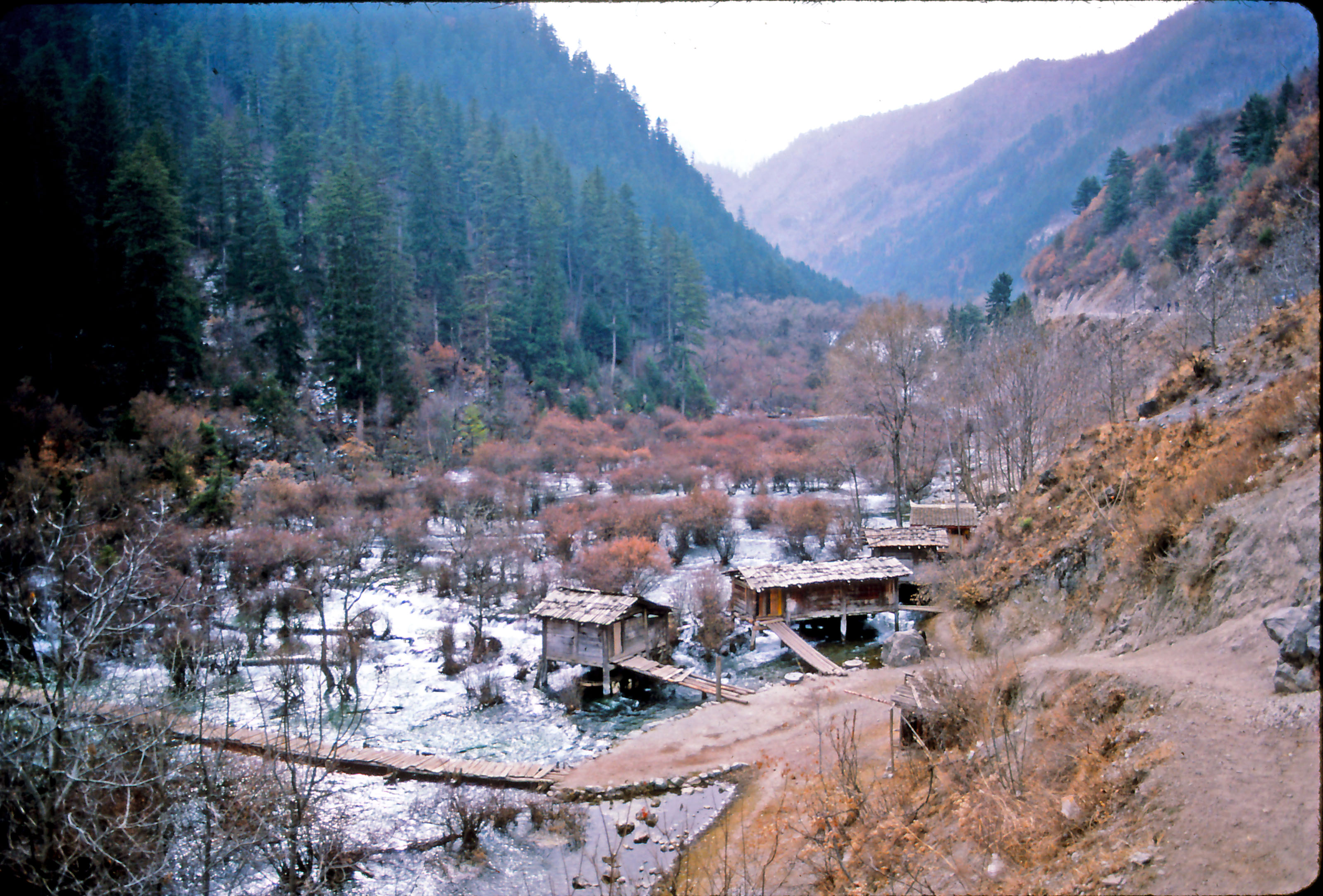
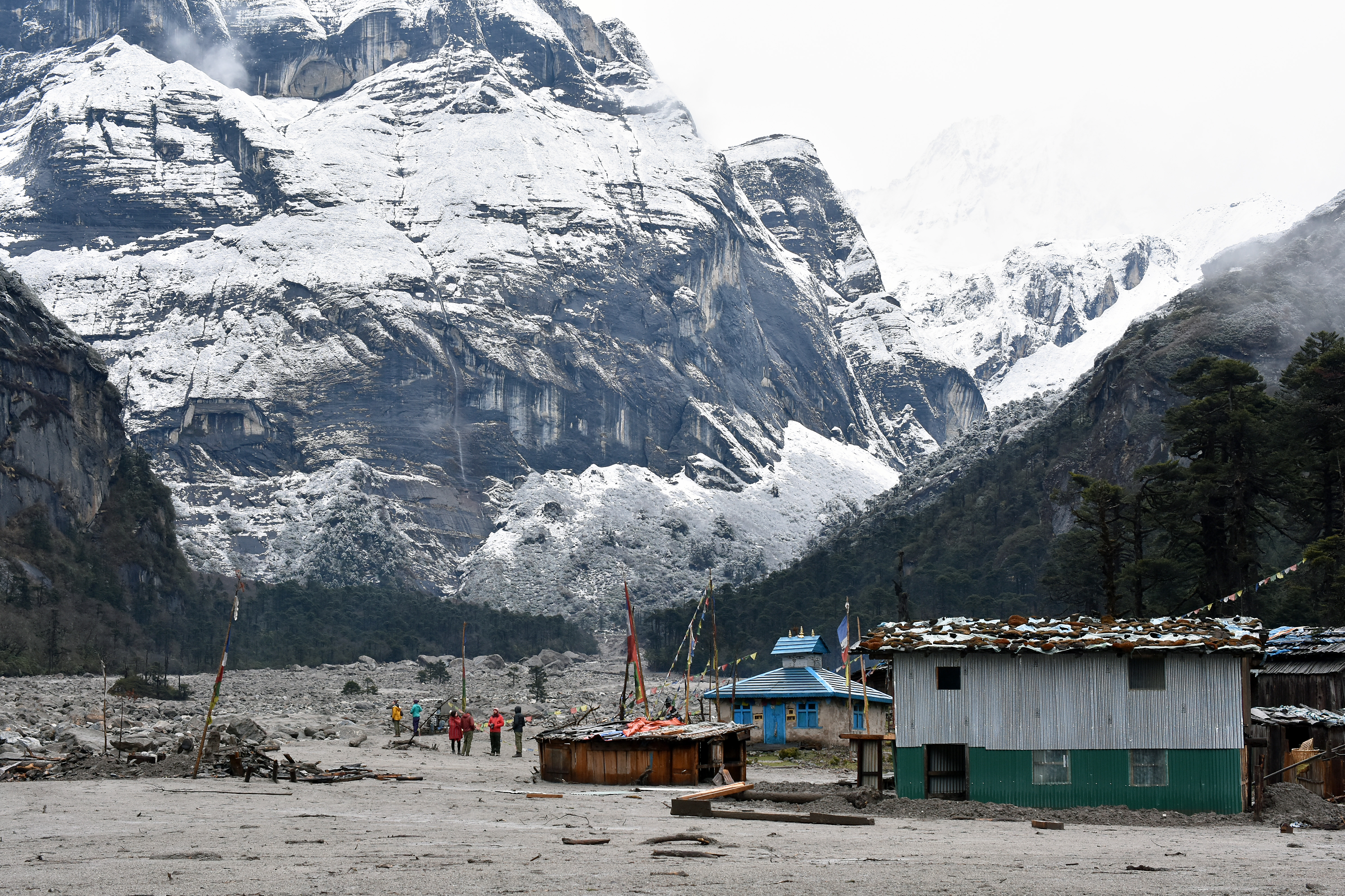
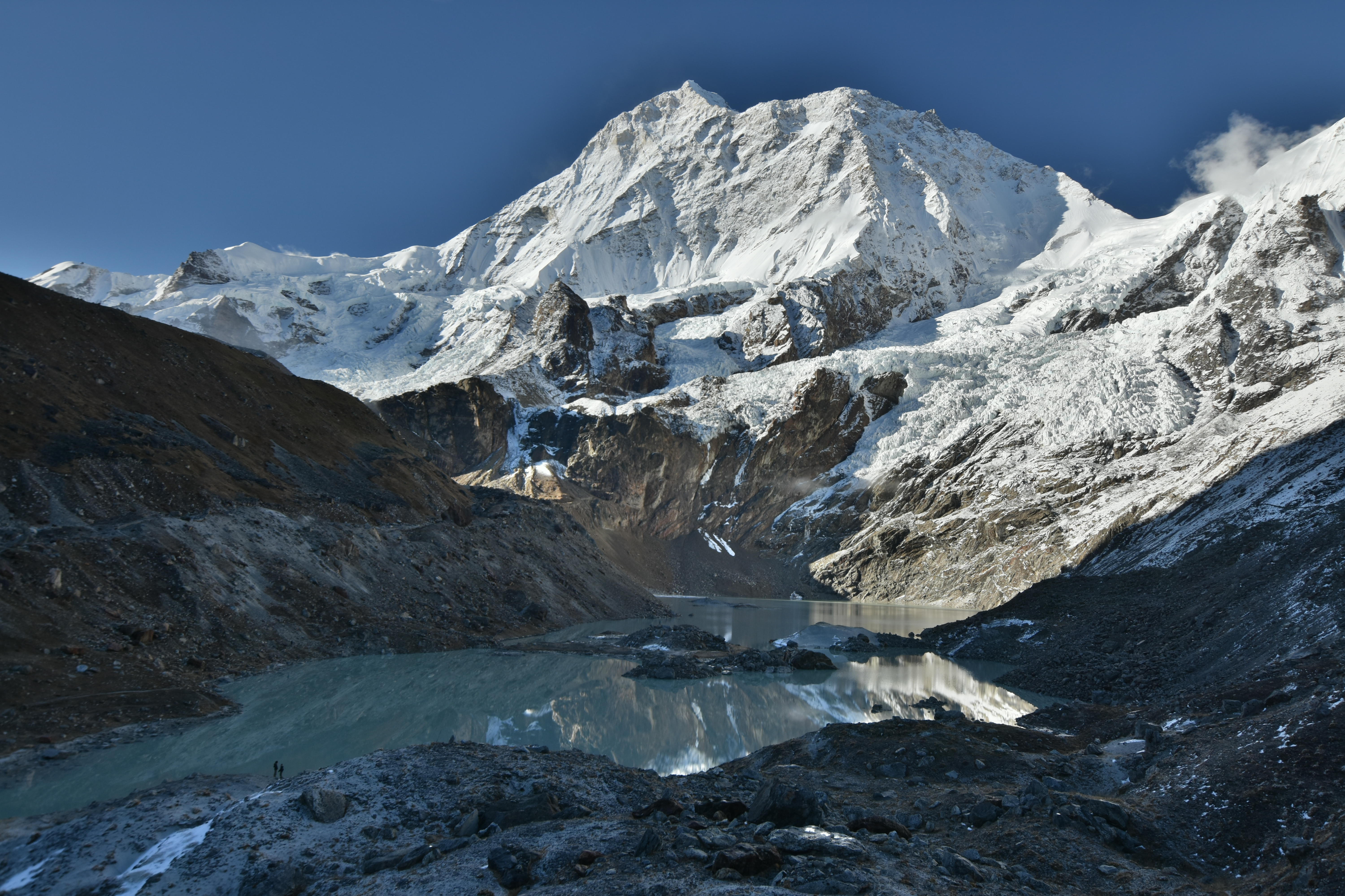
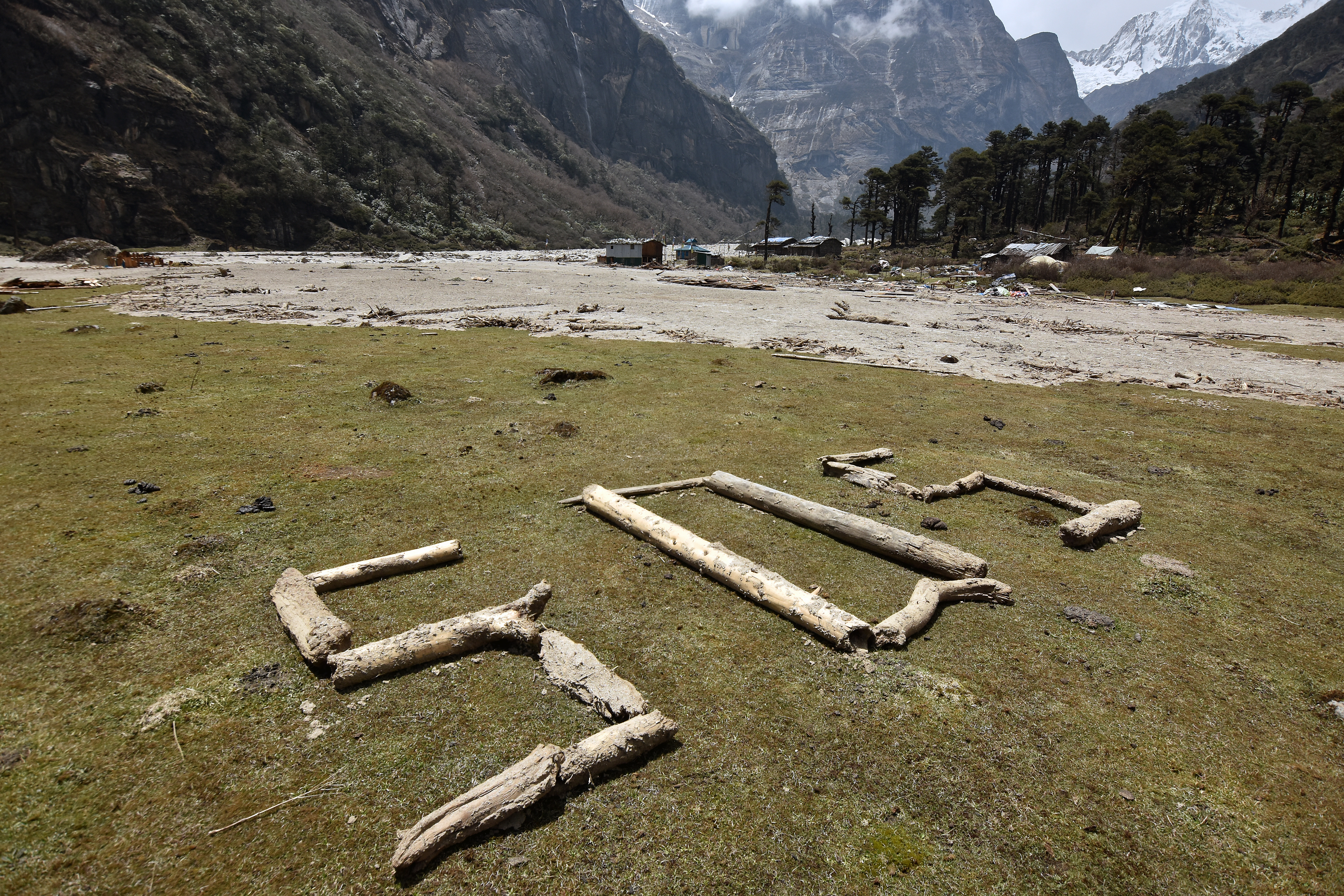
Debris from the April 20, 2017 glacial lake outburst flood tore into late-successional forest along the left side of the Barun Valley above Yangle Kharka, Sankhuwasabha District, Nepal.
On April 20, 2017, a small glacial lake burst its moraine dam and discharged into the Barun river valley, a tributary of the Arun River in Sankhuwasabha District, Eastern Nepal. Rocky debris from the moraine accompanied the glacial lake outburst flood (GLOF), and tree trunks were swept before the descending mass. By Himalayan standards, this event seems to have been relatively modest, but it impacted an area of recognized beauty, biological diversity and cultural significance. This report informally summarizes the observations of a Wildlands Studies team led by Chris Carpenter, Zach Crow and Jamyang Lama and accredited through Western Washington State University in the United States of America. Our team included 15 undergraduate students. We visited the GLOF site 16-24 days after the event.
The Barun valley provides mountaineering access to Makalu, an 8481 meter peak on the border of Nepal and China, and it has become increasingly popular as a trekking destination. Many landscape features within the valley are deeply sacred to local people including those of Sherpa, Tibetan and Rai ethnicity, who regard the Barun as one of the sacred valleys of the Kembalung Beyul (Reinhard, 1978). An uncommonly wet climate and steep topography reduce human impact: some of the Himalaya’s most intact middle-elevation forests are found in the catchment of the Barun river.
The outburst flood occurred just as our Wildlands Studies team was aloft on Yeti Airlines, en route from Kathmandu to Tumlingtar, our starting point for a month-long course of field studies in Makalu-Barun National Park and Buffer Zone. We had planned ten days in Tamkhu and Mangtewa, agricultural landscapes below 1500 meters elevation, and twenty days on the trekking route to Barun valley and Makalu Basecamp. Wildlands Studies visited this region several times in the 1990s, but I had not been back in nearly two decades. I was excited and a little apprehensive to see what changes might have been wrought by years of civil war, political engagement and infrastructure development in the area, and curious as well, I confess, as to how my own body would handle the challenging terrain, a generation down the line.
Blocked by debris from the Barun Valley GLOF, the Arun River pooled then surged on the evening of 20 April, throwing these fish onto the bank near the Sankuwa confluence more than 40 kilometers downstream. This was our first intimation that there had been an outburst flood up stream. (April 21, 2017)
Our first inkling of an upriver disturbance was fresh fish on the morning of April 21. We had camped our first night on a river terrace where clear-water of the Sankuwa river disappeared into the turbid flow of the Arun. Late the previous night, we were told by villagers, the Arun river had risen abruptly, throwing fish onto the grassy bank. Local media were reporting that at 4 pm a landslide had dammed the Arun up near the village of Bhotkhola, near Hatiya (many kilometers upriver of our campsite), and that the army had been dispatched to secure the situation. After a few hours, we were told, the pooling waters of the Arun breached the debris fan, then moved forward, producing a downstream surge. Only several days later did we come to understand that the package of boulders that blocked the Arun river had come down the tributary we were intending to visit.
A member of the family that hosted us at the Sankuwa-Arun confluence from where we saw the surge on the Arun. At 400 meters elevation, this is the very lowest point in Makalu Barun National Park and Buffer Zone
For several days, we weren’t sure whether we’d be able to hike into the upper Barun at all. We’d heard some yaks and chauri (yak-cattle hybrids) had perished in the outburst flood, and that mountaineers or trekkers had been stranded for awhile, and I knew from past experience that the path along the Barun is landslide-vulnerable under the best of circumstances. It was only after we came up out of the hot jungle and entered Seduwa, along the main trekking route to Makalu Basecamp, that we learned the Barun valley trail was indeed passable, mucky in places but passable.
The crossing from Seduwa to the Barun valley entailed several days of climbing into cold rain and fog, followed by a steep descent. On Kongma Ridge we found what seemed to me an inordinate amount of snow for early May. Flowering rhododendron and viburnum offered more than adequate compensation though, and one of my students was lucky to see a red panda on the path just below the Kongma campsite.
Rhododendron hodgsonii, one of several species of rhododendron we saw in full flower en route to Kongma Ridge and the pass into the Barun Valley. (May 16, 2017)
We’d heard that lodges — the blue, galvanized steel kind now ubiquitous in the Himalayan hinterlands — had proliferated along this route to such a degree that it’s no longer necessary to camp. The American in me was conflicted about the ‘loss of wilderness’ that this implied, but in fact all of us were deeply grateful for the shelter provided by the enterprising souls of Tashigaon and Navagaon. In climatic terms, Kongma ridge spring 2017 was not a forgiving place and I fear we would have been unhappy campers had we relied on tents for the clients and caves for the porters as was the norm during our excursions in the 1990s.
Reaching Barun valley, we found that the glacial lake outburst flood had reconfigured the terrain to a certain extent, but the valley had not been devastated as we had feared.
In a nutshell:
1. The V-shaped section of the Barun Valley, below the pasture of Tematang (Pema Kharka), had been scoured and largely unburdened of its riverine bed load, which had previously filled the channel. We found expanses of naked bedrock exposed at stream level with intermittent stretches of fresh, compacted mud terraced on either side. The boulders and gravel comprising the bed load must have moved further downstream, or perhaps this material went all the way to the Arun river. This outcome contrasts to the ‘bottleneck’ scenario in which these reaches of the valley would trap debris with the potential to impound water in flatter upstream locations like Tematang and Yangle Karka (Byers et al., 2014). Mostly, the main footpath through scree and landslide debris was unaffected except in a few places where we had to detour upslope of avoid collapsed sections.
Sheets of high grade metamorphic bedrock exposed to river incision following the May 20 GLOF. Note terraced mud deposits on either side. Perhaps the mud was deposited and then rapidly scoured away in the days following the GLOF. (May 6, 2017)
Himalayan rivers usually flow over loose boulders. The Barun Valley GLOF removed much of this bed load from the V-shaped channel below Tematang. When the river flows over naked bedrock it can incise more rapidly. (May 6, 2017)
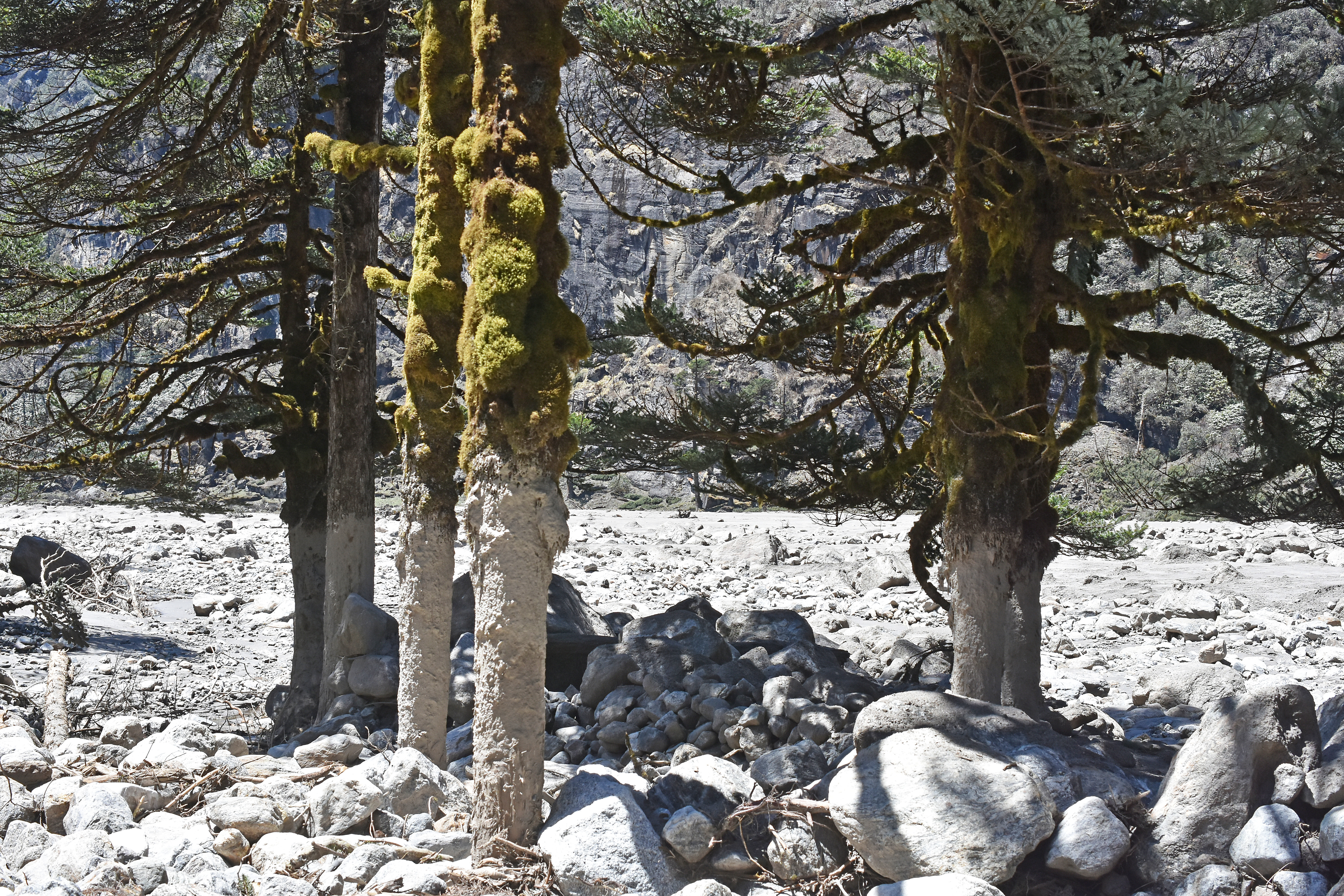
2. Yangle Karka, the largest pasture in the subalpine part of the Barun Valley, is now partially covered by rock and sand.
Yangle Kharka, covered by a fresh carpet by debris from the April 20 GLOF event. The vegetated islands are boulders that may date from some previous deposition event, or may have been left behind after the Last Glacial Maximum more than 10,000 years ago. (May 6, 2017)
There are house-sized boulders in the upper part, near Nghe Kharka, with finer clasts further down valley. Apparently the flood, after descending a relatively steep section of the valley below Riphuk, slowed, lost some of its transport power and shed debris when it reached the flatter expanse of Yangle Kharka, a sediment filled lake basin (Byers et al., 2014).
(May 7, 2017)
These boulders were transported the Barun River during the 20 April GLOF and settled at Nghe Kharka. (May 7, 2017)
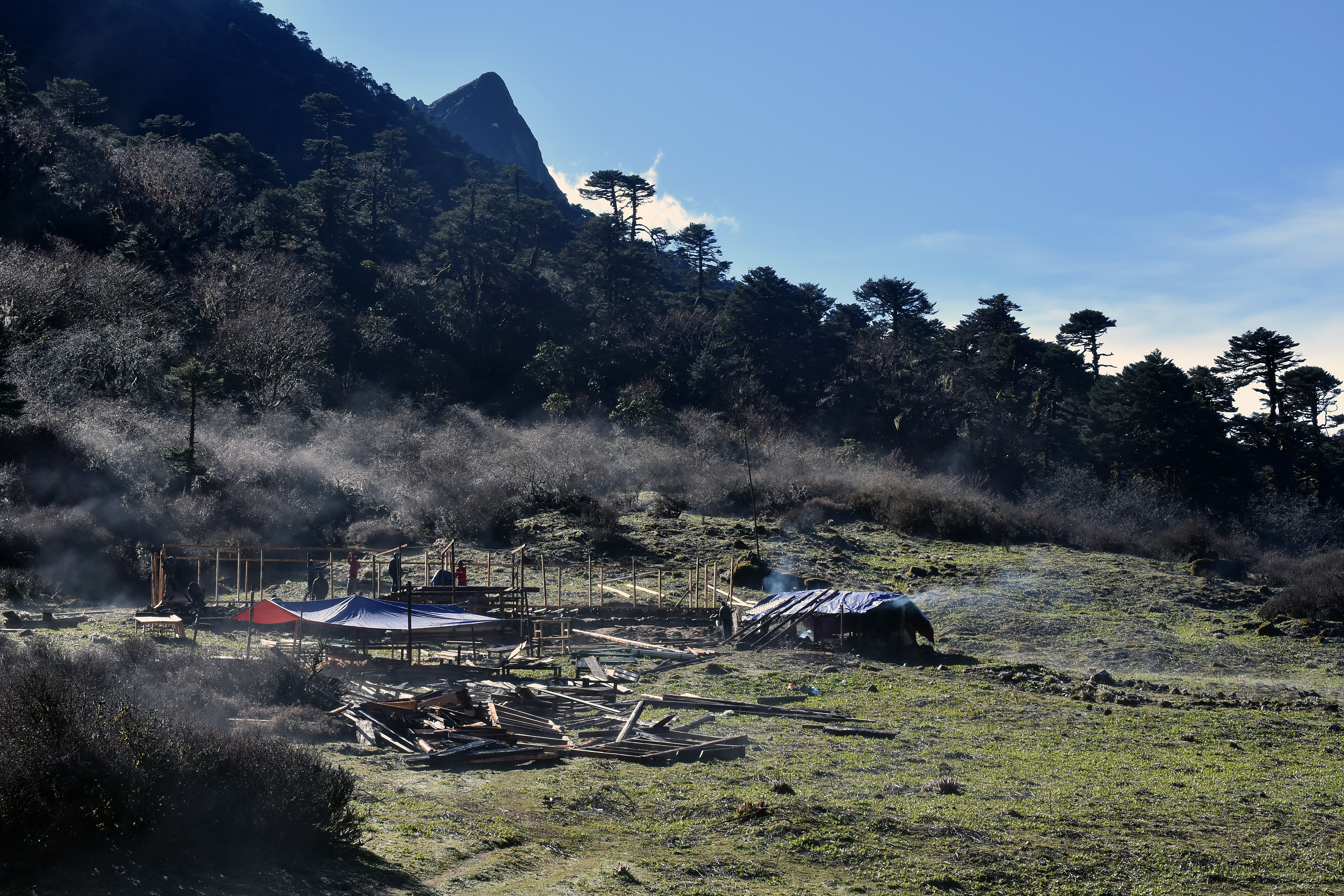
The part of Yangle Kharka to the right of the Barun River, where we used to like to camp, has been completely covered by rock, sand and mud. The section just to the left of the river, including the original Buddhist gompa and a couple of newer wood and galvanized steel lodges has also been buried by a meter or so of debris. Lobes of fine sediment have invaded low-lying areas to the left of the river, but large areas of pasture, elevated a few meters, are unaffected. Some of the large, moss and tree-covered boulders, (glacial erratics?) that punctuated Yangle Kharka before the recent flood remain, standing salient amidst the fresh debris.
Lodges clustered around the Buddhist gompa in Yangle Kharka were destroyed or severely damaged by the 20 April GLOF event. The new gompa just avoided the debris flow, but the old gompa and most of the mani wall were destroyed. (May 6, 2017)
Lobes of fine sediment pooled in the low-lying parts of Yangle Kharka, then dried to a hard, sandy surface. (May 7, 2017)
Forests along the two kilometer section of the valley that extends upward from Yangle Kharka to Nghe Kharka were thrashed severely by outburst flood debris. Byers et al. (2014) cite evidence from the shape and size distribution of the forest vegetation that similar damage may have occurred here on prior occasions during the past century, although perhaps not as severe as the event of April 20. Our group observed hardened mud coating the mossy trunks of fir trees to a height of 3-4 meters.
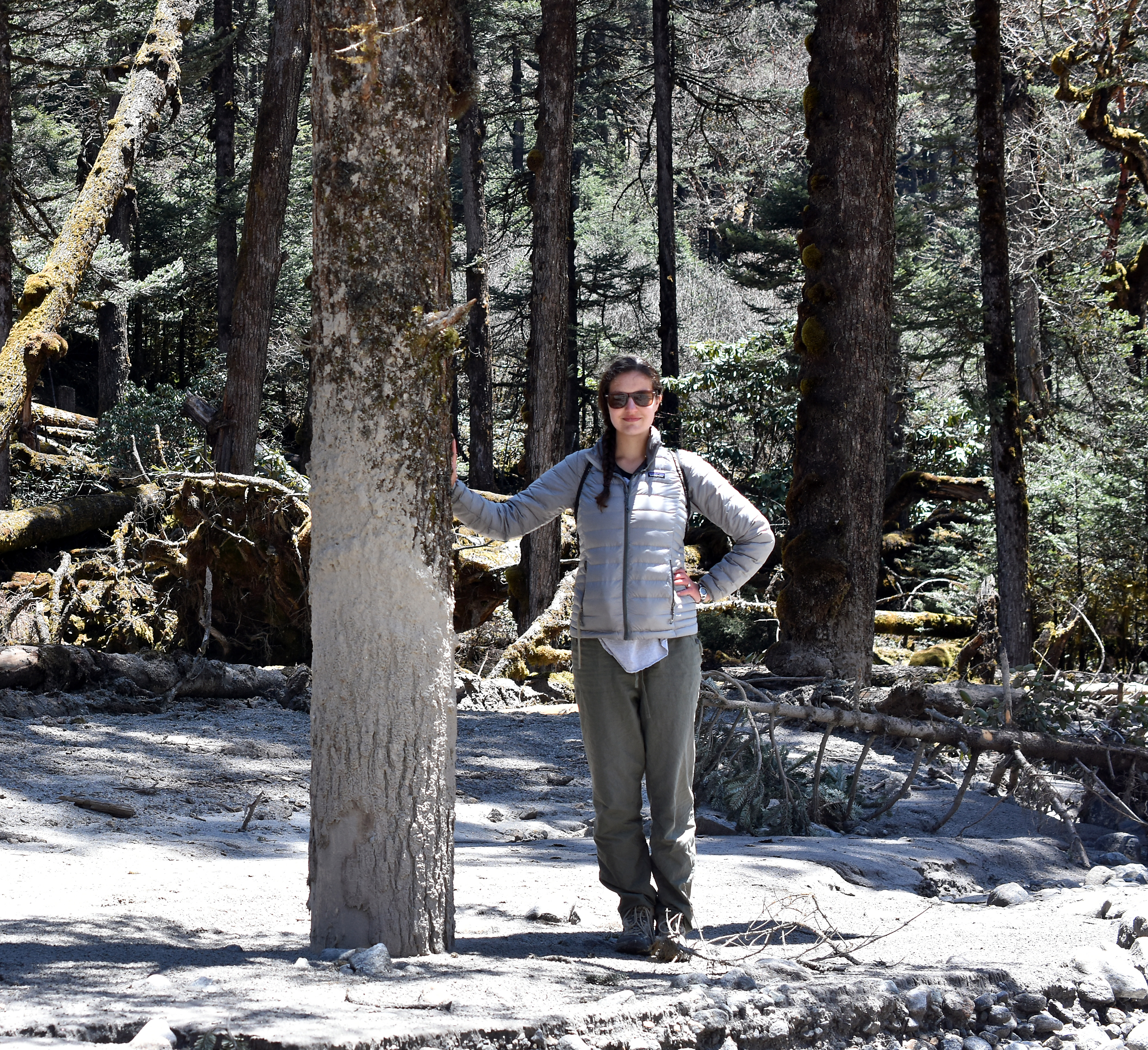
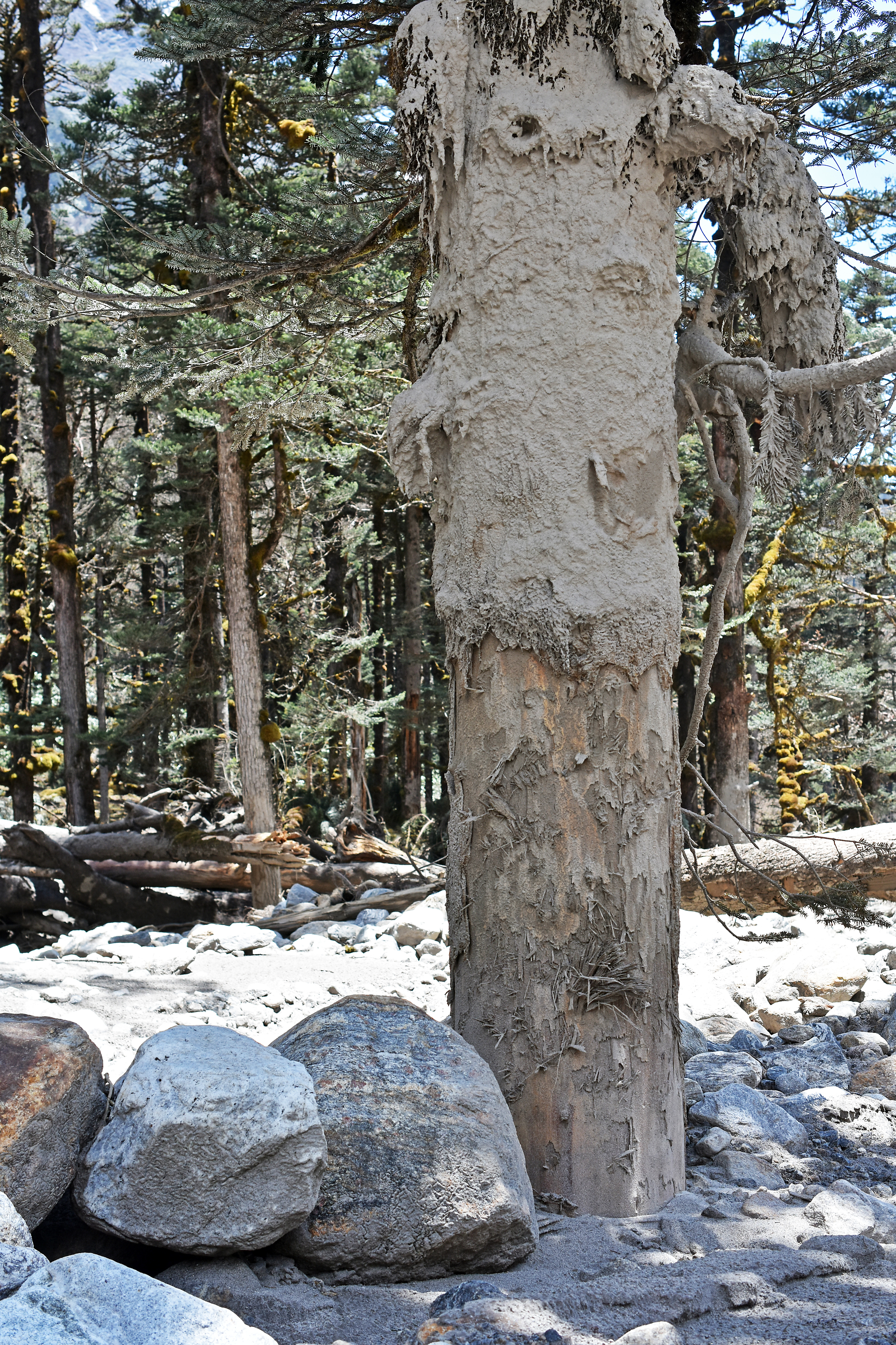
Delaney Corcoran providing scale. The mud coats this fir tree to a height of two meters in the upstream direction. Note the tree lost some bark at the base, but may have retained enough to survive. (May 7, 2017)
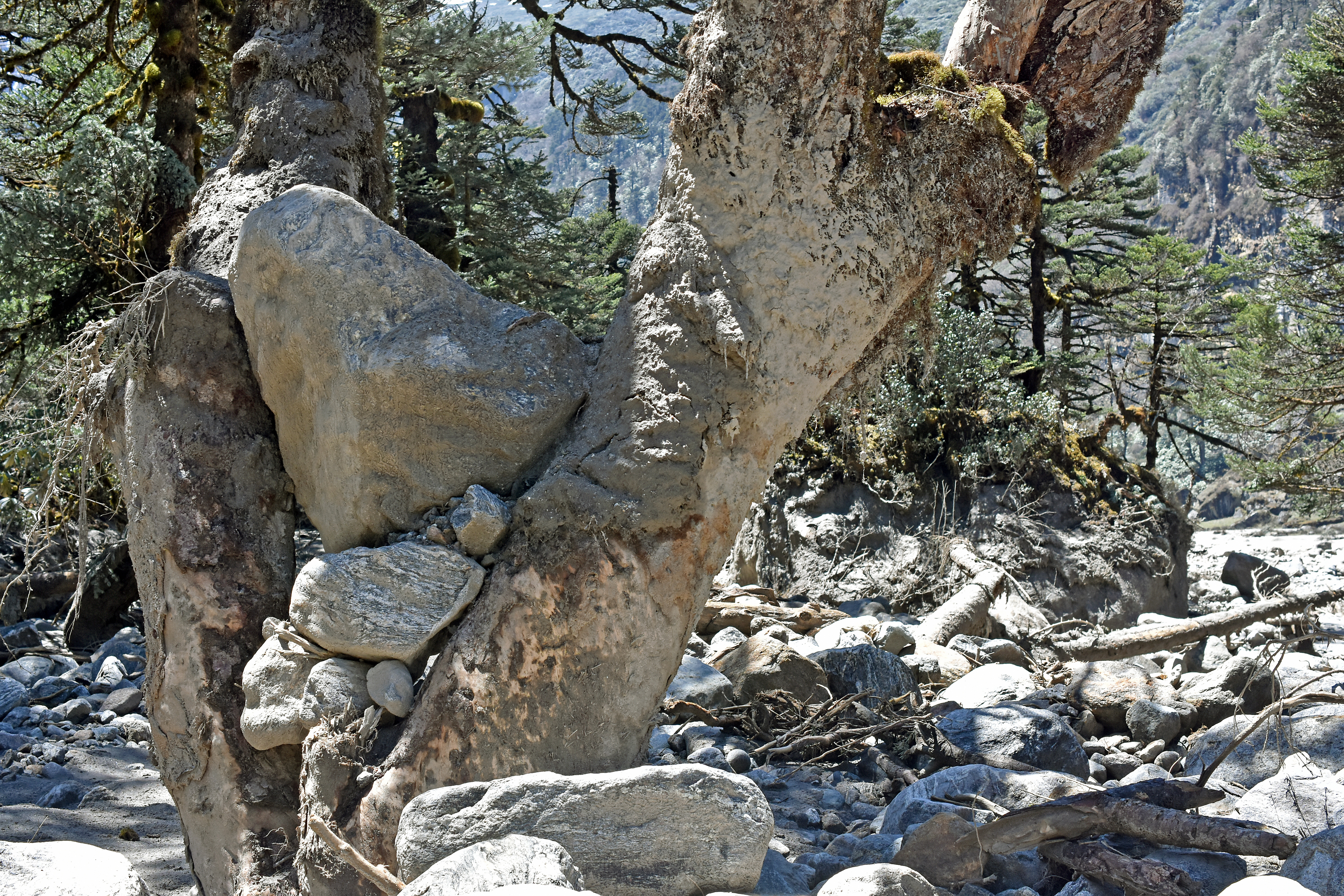
Birch trees with forking trunks have strained cubic meter sized boulders from the water column and hold them high above the ground.
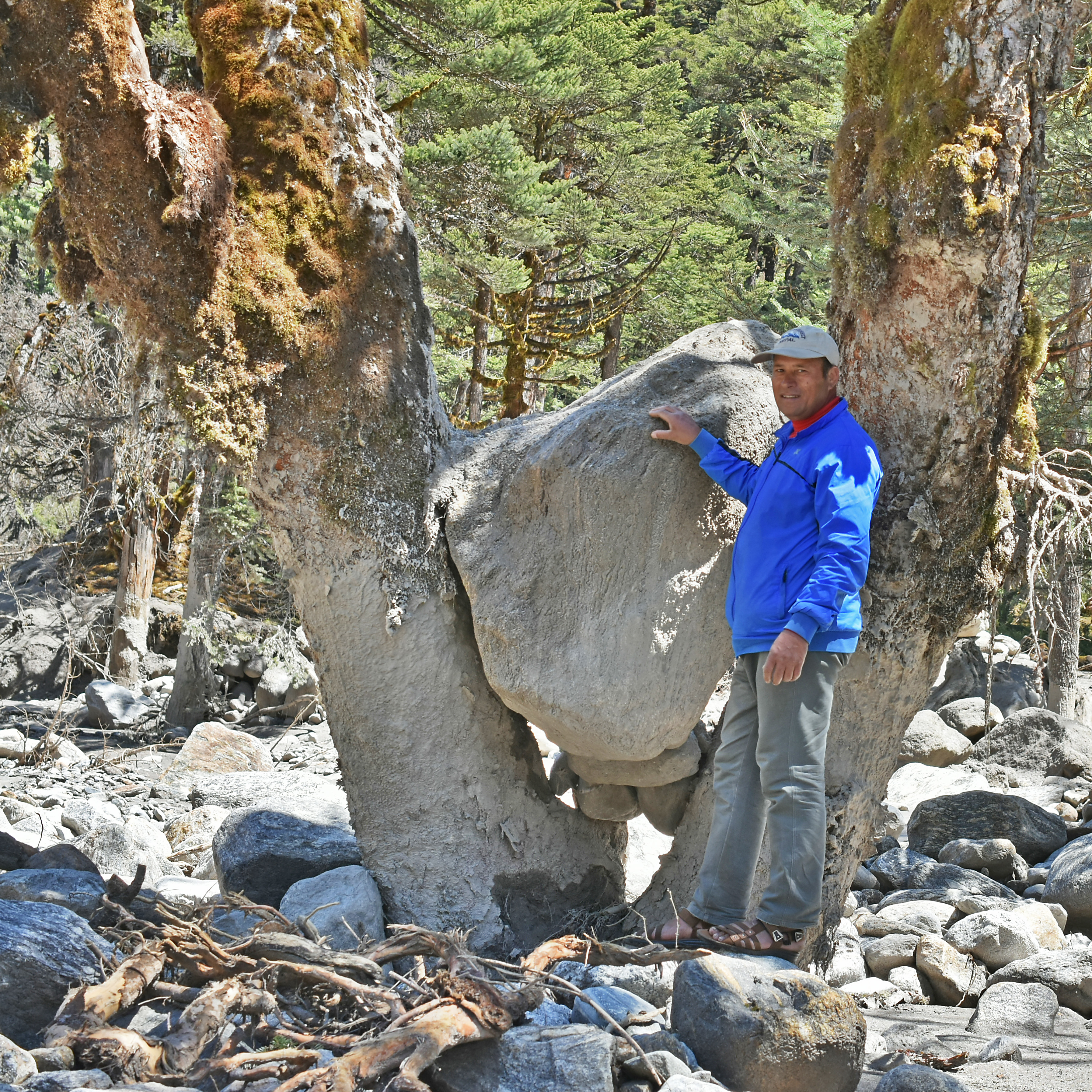
Om Bahadur provides a sense of scale for this lunking boulder that got itself wedged between the forked limbs of a large birch (Betula utilis) tree at the edge of the forest just upstream from Yangle Kharka (May 7, 2017)
The height and large size of these snared rocks attests to the power of the GLOF that swept the margins of Yangle Kharka on 20 April 2017 (May 7, 2017)
Abrasion from finer sediments has stripped bark clean from the base of numerous trees that might otherwise survive the inundation.
Bark at the base of this fir tree (Abies spectabilis) was abraded away by rocks suspended in the GLOF. A tree cannot survive this kind of damage. (May 7, 2017)
These fir trees, debarked at their base by rocks suspended in the GLOF, are probably goners. (May 7, 2017)
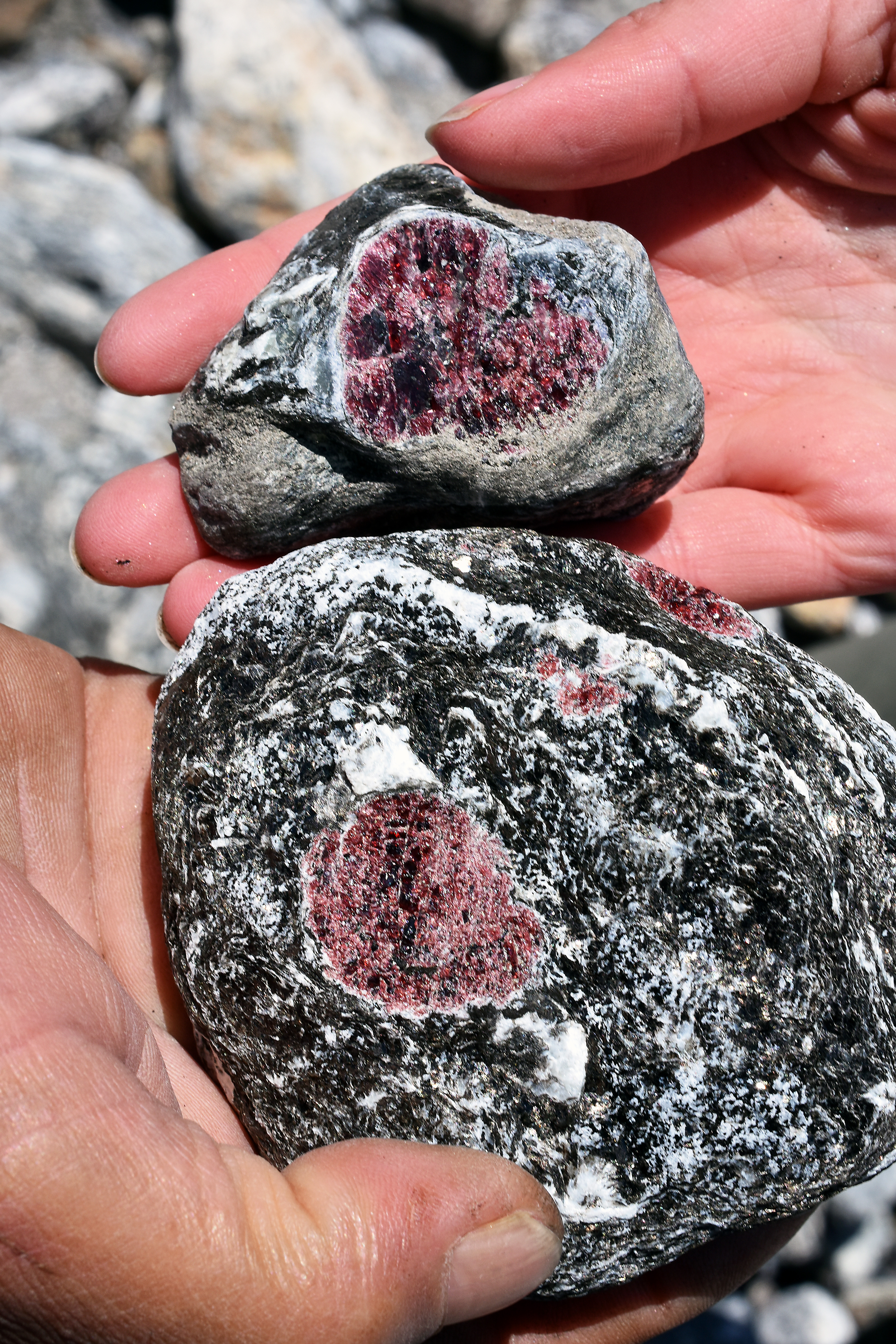
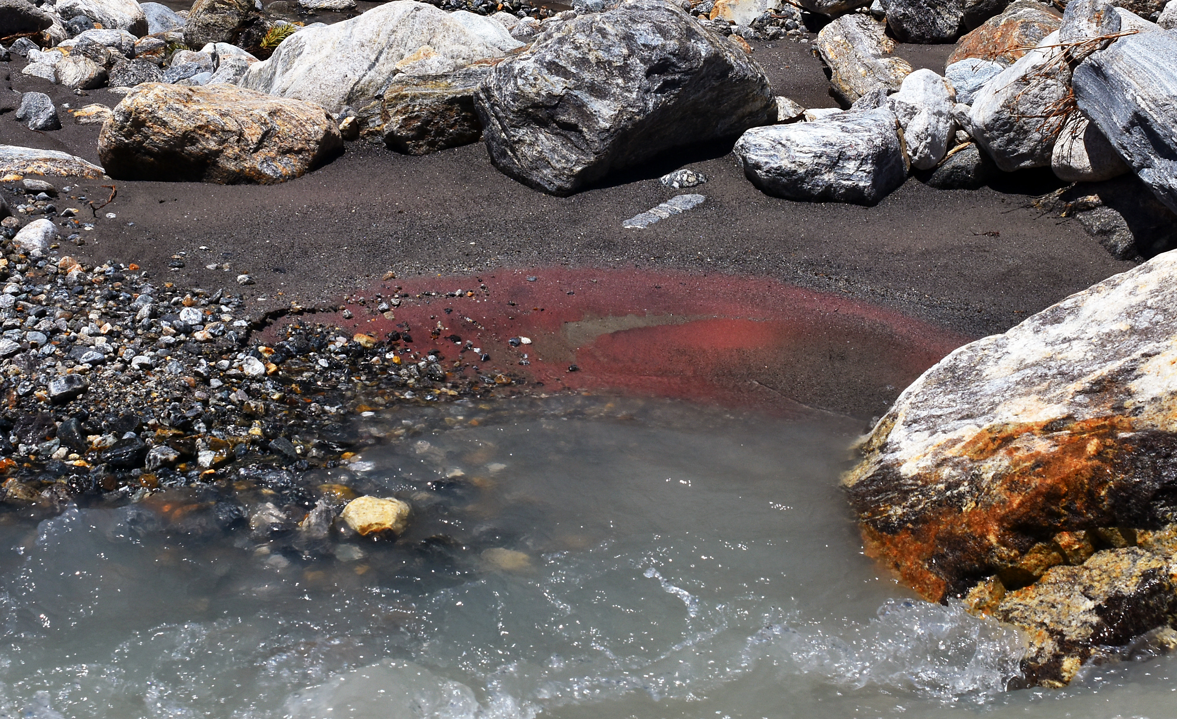
Among the rocky debris, many large, beautiful garnets were exposed in gneisses that had disintegrated on their turbulent journey down valley, and fresh mud along new river channels had already acquired a crimson patina of garnet dust.
Many large garnets appear in gneisses transported to Yangle Kharka during the April 20 GLOF event. (May 7, 2017)
Garnet powder has already accumulated along the edge of a braided channel amongst GLOF debris upstream from Yangle Kharka (May 7, 2017)
People who were present at Yangle Kharka on April 20 first noticed a cloud of dust rising up valley and heard a fearfully loud roaring noise. The time was late morning, getting on towards noon. A few minutes after the first disturbance (we heard estimates of ten and thirty minutes), the flood reached Yangle Karka. This delay between the sound and the fury, and the flood’s midday occurrence, may be why there were no human fatalities. According to witnesses at Yangle Karka, the flood reached maximum flow in the first few minutes, surged hard for about one hour, then declined over the remainder of the afternoon to a normal rate. By late afternoon, the debris train had traveled the length of the Barun valley and debouched into the main stem of the Arun river, damming it temporarily. The dam gave way shortly thereafter, producing a non-catastrophic surge downstream.
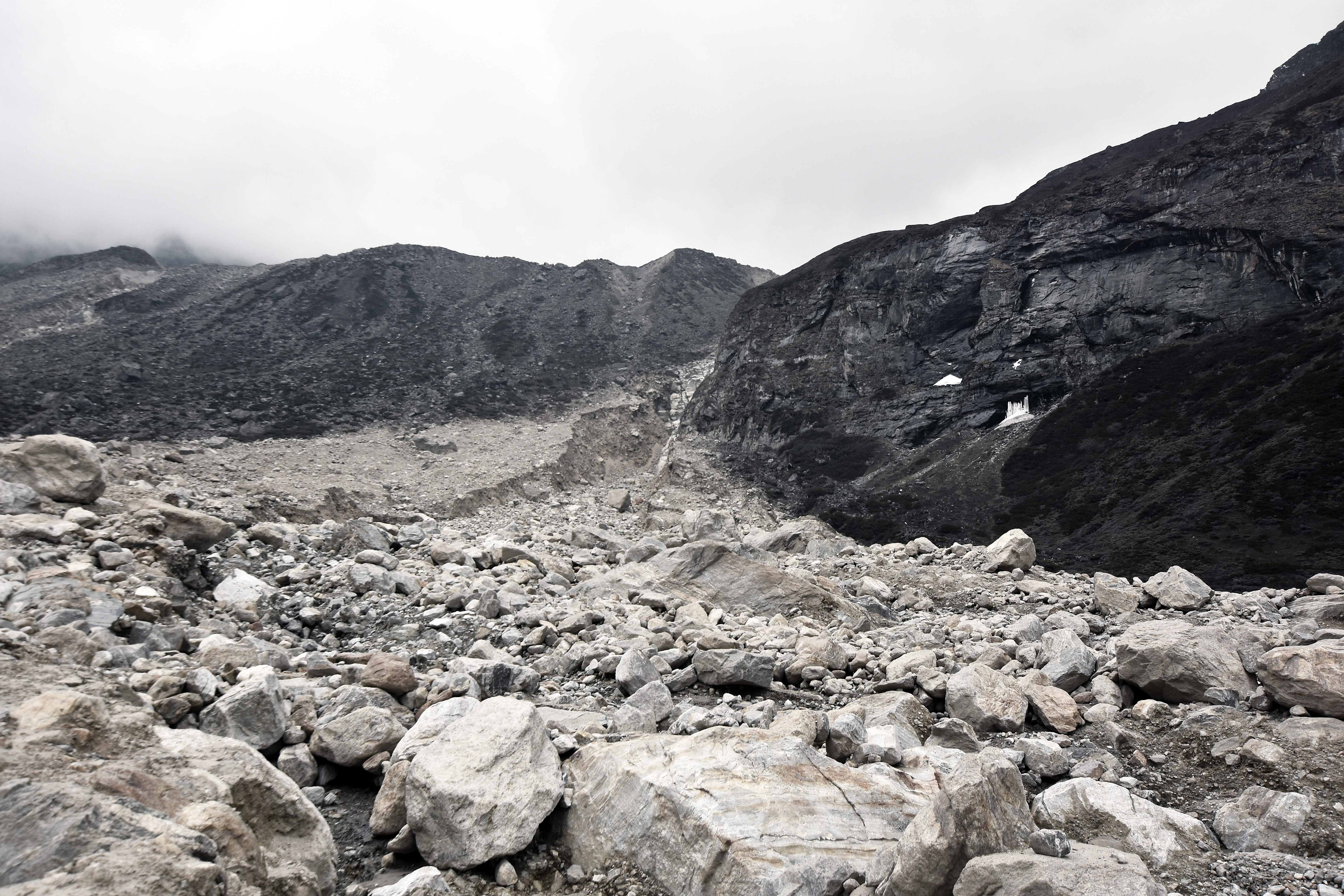
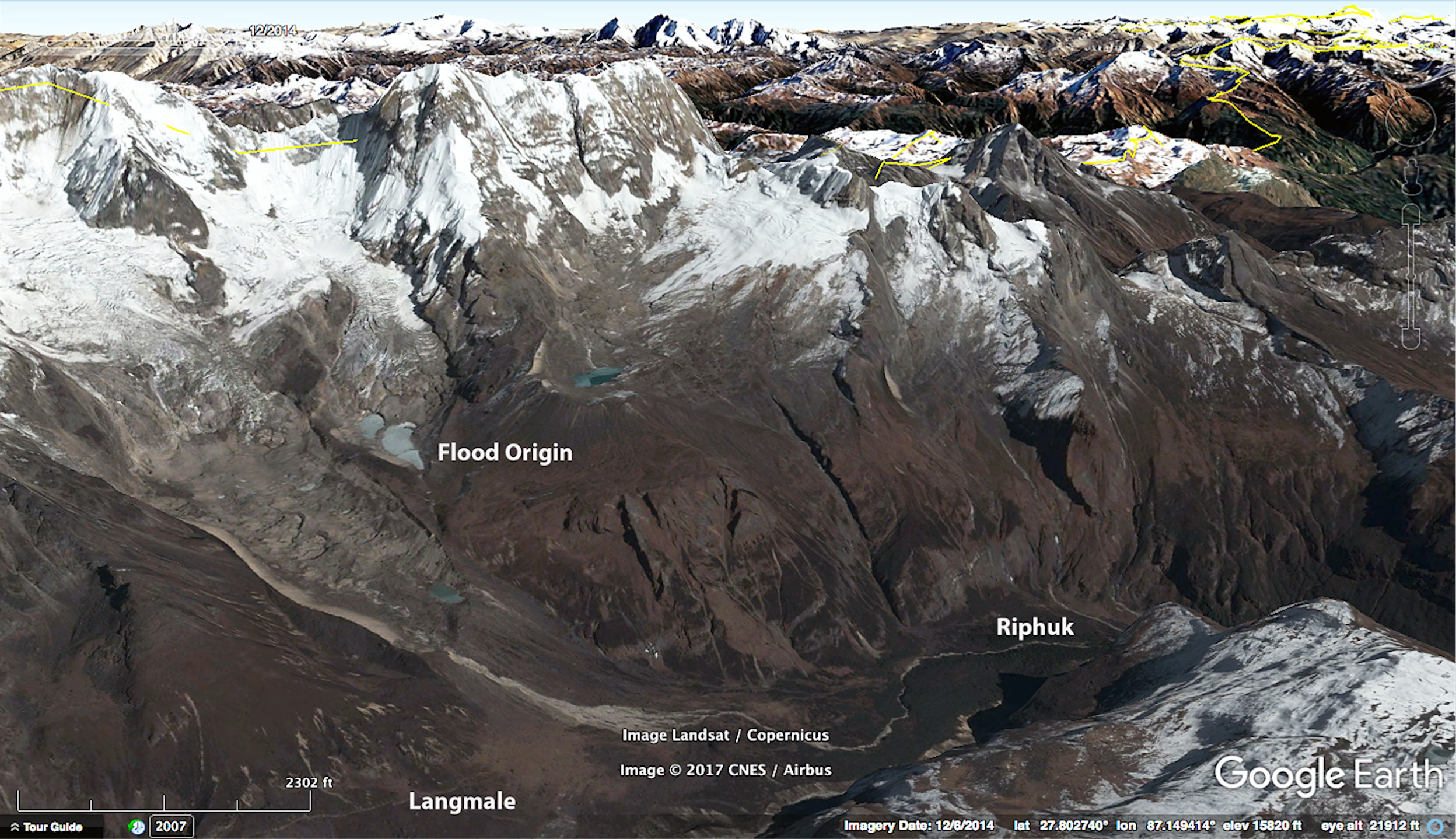
3. The Source of the Outburst Flood. On our way from Riphuk to Langmale, it was necessary to cross debris from the upper part of the outburst flood, which appeared rather formidable on the approach from below. The crossing above Riphuk required about 400-1500 meters of walking through fresh rock debris, depending on one’s inclination to find an alternative route by bushwhacking through willow and juniper. The most imposing part is a bluff, perhaps 30 m high on the right side of the channel that carried the flood. But the debris is well-cemented and competent, and a path of sorts has already been established. It is only necessary to look out for the occasional patch of quicksand in flat, depressed areas.
Channel through which the GLOF drained from Seto Pokhari toward the Barun River, between Riphuk and Langmale. Ascending to Langmale and Makalu Basecamp, one crosses from right to left.
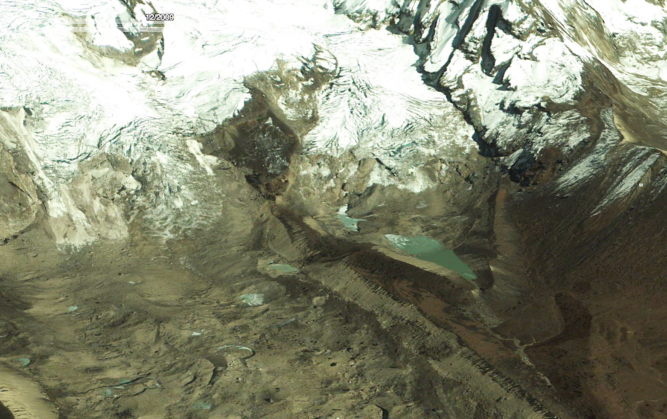
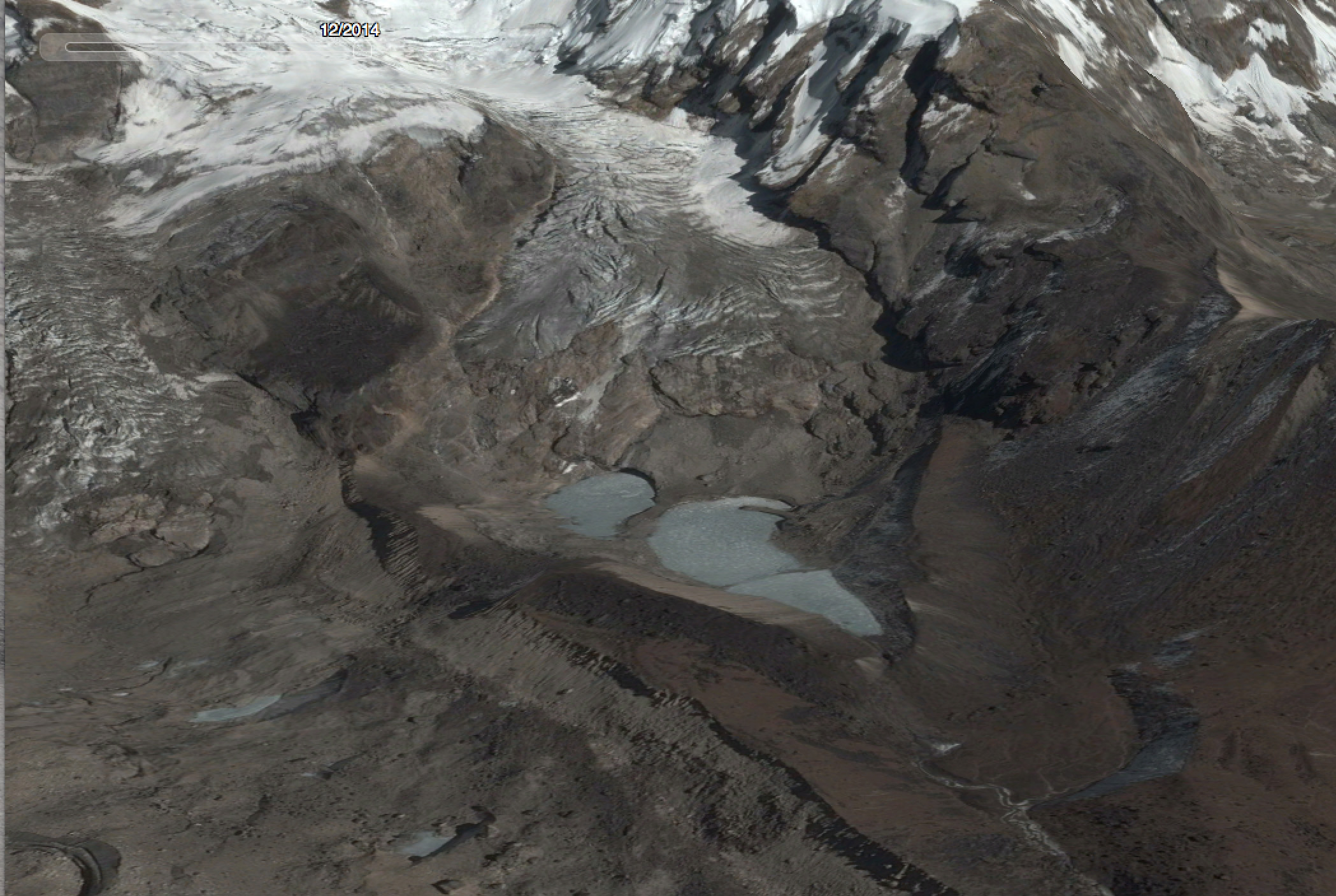
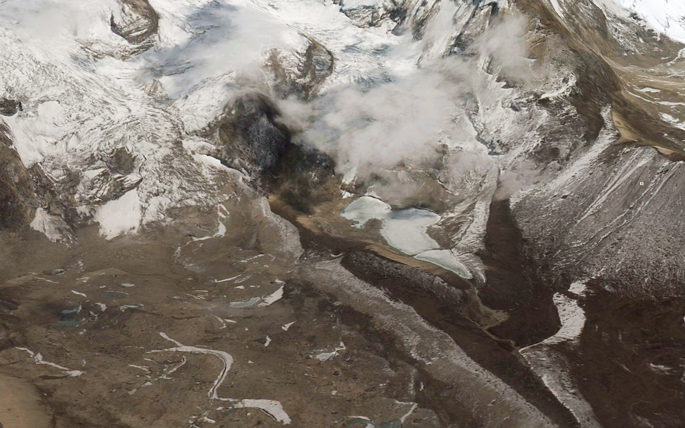
In its upper reaches, the outburst flood was most destructive. The source was a lake the local people call Seto Pokari (27.812° N, 87.138° E), one of several small water bodies (~0.1 km2) located at 4800 m elevation in a moraine-bounded basin a few hundred vertical meters above the left bank of the Barun River between Riphuk and Langmale. We were not aware of any witnesses to the event at either of those places, the caretakers of lodges at Riphuk and Langmale were all at Makalu Basecamp at the time, but it is understood by the seasonal residents of Barun Valley that the outburst flood happened when a large avalanche fell into the lake from above, displacing its contents and causing them to breach and break the terminal moraine that had impounded them.
Seto Pokhari, December 2009. Note in this and the following renderings how the lake increases in size between 2009 and 2016. (courtesy Google Earth)
Seto Pokhari, December 2014 (courtesy Google Earth).
Seto Pokhari, April 2016 (courtesy Google Earth).
‘Seto Pokari’ — White Lake — is about the most generic name imaginable for a periglacial water feature in the Nepal Himalaya, so we didn’t realize until we arrived in the upper Barun that the GLOF we’d been seeing had issued from this obscure side basin and not the vastly larger water body impounded above the terminus of the West Barun Glacier. We’d already surmised that it hadn’t come from the other Seto Pokari, a beautiful lake that reflects Makalu a few hundred meters above basecamp
The other Seto Pokhari, ensconced in the lower moraine of the Barun Glacier, just above the Makalu Basecamp complex of lodges. (May 11, 2017)
We spent one morning hiking from Langmale up the moraine in the direction of the GLOF’s origin, and I got the impression from previous erosion scars above dry lacustrine sediments that this basin is a likely source for the relatively frequent, middle-sized outburst floods that Alton Byers and his colleagues found evidence for in 2014. On our day in Langmale, threatening weather and a vague sense of menace kept us from venturing too far up into the basin.
Eyewitness accounts from Yangle Kharka concur on one point, the outburst was accompanied by a great deal of dust. We noted several millimeters of dust fall on the ground and coated on the leaves of alpine rhododendron in the vicinity of Langmale, about a kilometer up valley from the outburst site. Dust fall declined gradually in the direction of Makalu Basecamp and we saw no dust on vegetation in the direction of Riphuk, down valley. This pattern conforms to the daily springtime cycle of strong upvalley winds commencing in the mid-late morning, but isn’t easy to reconcile with evidence of strong flood-generated winds in the downstream direction.
Dust settled on leaves of Rhododendron setosum at Langmale, a kilometer up valley from the GLOF of 20 April 2017. (May 9, 2017)
A couple of kilometers below the outburst lake, the Barun river descends between the pilgrimage site of Amabhuchung (the rock that evokes a pregnant woman) and Riphuk (a site associated with Guru Rimpoche, founding sage of Tibetan Buddhism).
View up the Barun Valley. The rock on the left is Amabhuchung, a pilgrimage site. The GLOF track is visible from its origin in the right hand background across the foreground of this image. (May 8, 2017)
It is here that the Barun river veers right and descends more steeply, and it is here that the flood was particularly destructive. Local people explained how a rock outcrop on the steeply descending section above Yangle Kharka steered flood waters into the late-successional fir forest that grows in this area, destroying many trees. Eyewitness accounts (which we heard second-hand) referred to the leading edge of the outburst flood as a “30 foot wall of tree trunks” and locals mention a great tearing roar, lots of dust and strong wind as the surge passed through. We noted, where the path passes through the Riphuk fir forest, that there was a great deal of recent wind throw, and that numerous mature (senescent?) fir trees had been snapped and toppled in a direction facing away from the flood, that is, they had broken as though the wind had been blowing down valley, opposite the expectation for a pre-monsoon squall. Local people later told us that yes, indeed, trees in the forest below Riphuk had been toppled by strong winds driven by the outburst flood. One family lost 35 head of yak and chauri (yak-cattle hybrids) in the pastures below Riphuk. At least one carcass had been salvaged, its meat dried to strips of sukuti and sold to protein-craving visitors like ourselves.
Happily, no human fatalities were reported from the 20 April GLOF event, but some trekking and mountaineering groups were stranded at Yangle Kharka when the trail down valley and all the bridges were destroyed. It seems they made their way out on foot. We are not aware of any evacuations. (May 7, 2017)
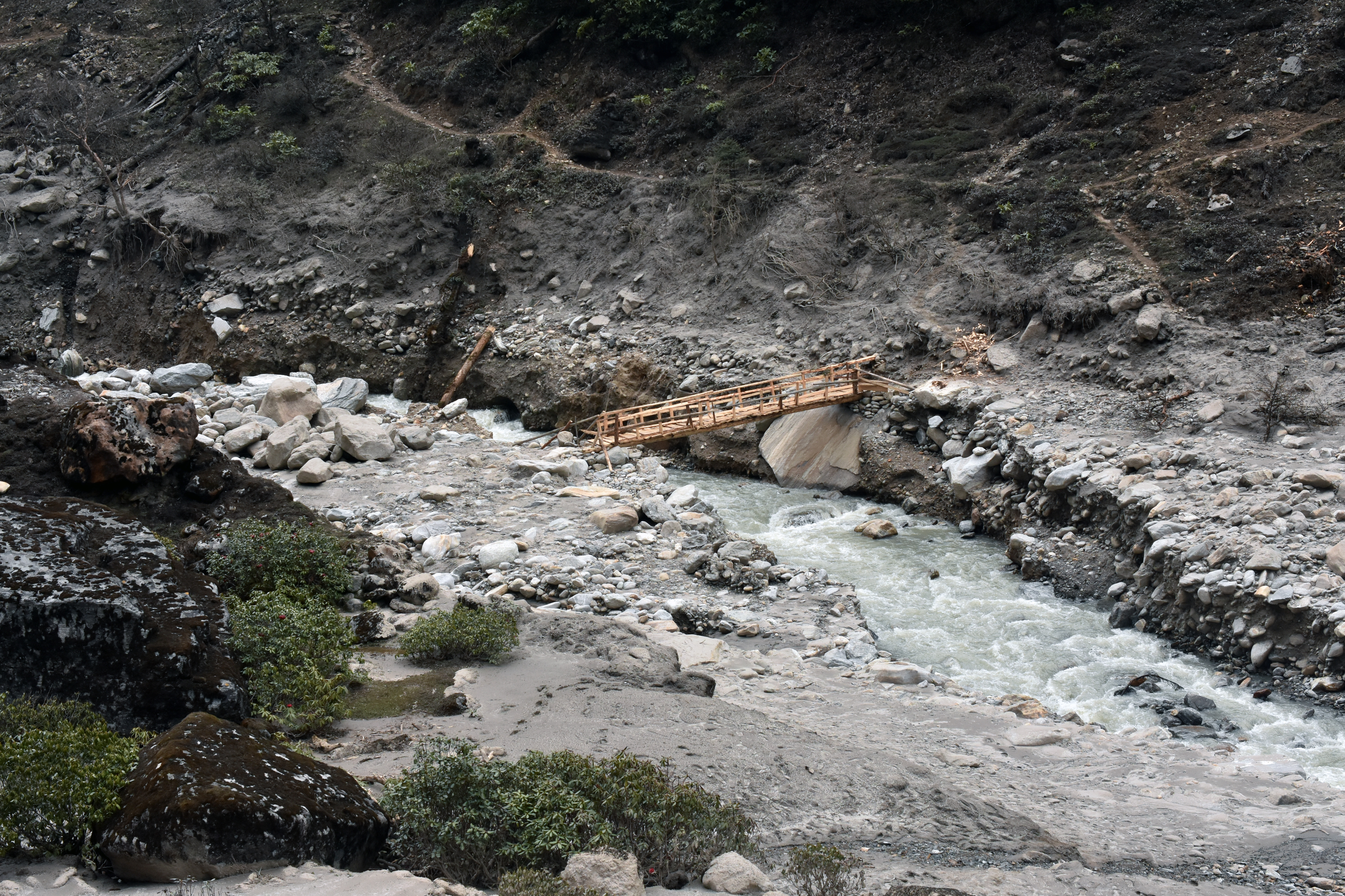
Seasonal residents of the Barun Valley, mostly Sherpa people from the villages of Navagaon and Tashigaon in the Kasuwa valley to the southeast, suffered obvious economic hardship and much inconvenience from the glacial lake outburst flood, which coincided with the onset of the mountaineering season on Makalu. The response we saw was proactive and self-reliant, as befits people who have spent generations in a particularly remote, steep, wet corner of the Nepal Himalaya. As a case in point, the main path that followed the right bank of the Barun from Tematang to Yangle Karka had been obliterated, so a secondary path on the other side of the river was put into use. The family that maintains the lodge at Tematang wasted no time building a temporary bridge within a few days of the flood, to facilitate evacuation from the area. By the time we arrived in May 6, they had upgraded this to a proper plank bridge made from salvaged fir. They accepted donations for its construction, but weren’t soliciting them.
Newly constructed bridge at Tematang. The old trail on the right side of the Barun River was destroyed, so now it is necessary to cross to the left side of the river for the walk from Tematang to Yangle Kharka. (May 6, 2017)
When we first reached Yangle Karka on May 6, the old gompa, destroyed by the flood, and been uncovered and some of the sacred objects had been removed for safekeeping. Wood framing and sheet metal from two destroyed guesthouses had been moved to the upper part of the pasture on the left side of the river. By the time we passed Yangle Karka the second time, on our way down on May 13, construction was well underway on two new lodges perched at the upper reaches of the pasture. They will be situated well away from the river and will benefit from a better view of the sacred Shivadhara massif so spectacular across the valley, and perhaps warmer temperatures and less wind, due to their sheltered, upslope location.
Rebuilding a lodge in the upper part of Yangle Kharka. Building materials were salvaged from the old lodge which was destroyed by the April 20 GLOF. This may prove to be a warmer, more favorable location. (May 14, 2017)
Acknowledgements:
Sincere thanks to our students, patient with my foibles, and to our guides, exemplary even by the high standards of Nepal, who helped to make me feel safe and capable on this program, despite myself. Om Bahadur Basnet, Bhakta Gurung, Kumar Basnet, Deepak Lama and Dol Bahadur Gurung, you are all among my heroes. And I wish to acknowledge the critical role of the Wildlands Studies program to make experiences such as these possible.
References:
Byers, Alton C., Elizabeth A. Byers, Dambar Thapa. 2014. Conservation and Restoration of Alpine Ecosystems in the Upper Barun Valley, Makalu-Barun National Park, Nepal. Final Report: National Geographic Society Conservation Trust Grant C259-13. The Mountain Institute Technical Report No. 2014.11.
Reinhard, Johan. 1978. Khembalung: The Hidden Valley. Kailash – A Journal of Himalayan Studies Kathmandu 6(1): 5-35.
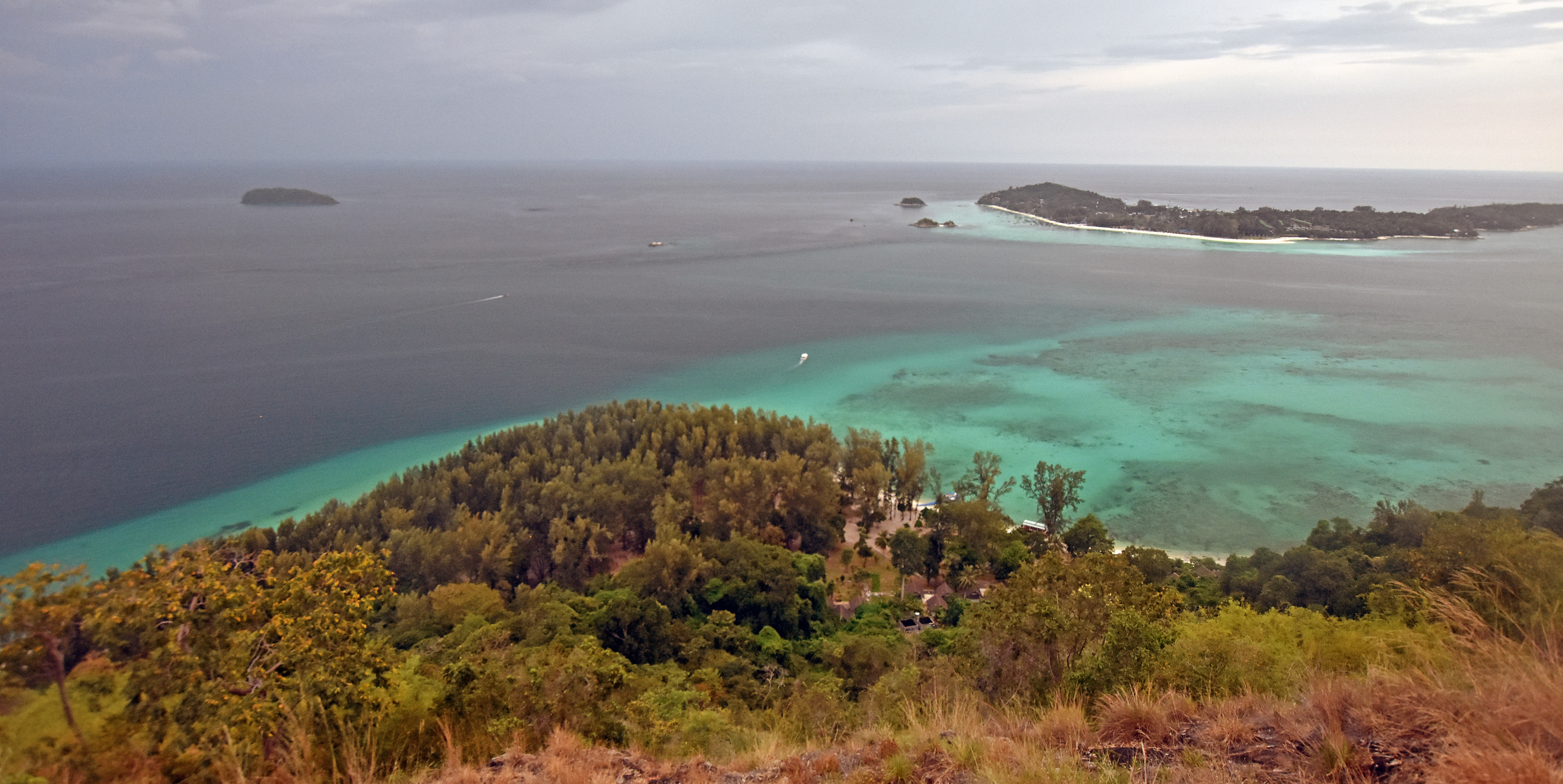
Wildlands Studies students Megan, Michelle, and Joanna at the top of Chado Cliff in 1995. Chado Cliff looks southward over Laem Son, the national park substation on Adang Island, Tarutao Marine National Park, Thailand. The sandy beach in the background does not exist anymore.
Every February Wildlands Studies visits Adang Island in Tarutao National Park, Thailand to learn about marine ecology. Our students collect information about the fringing coral reefs around the island. In addition to whatever is happening on the coral reefs, we have seen (and measured) a significant reconfiguration in the shape of the beach where we stay. This post is about that change.
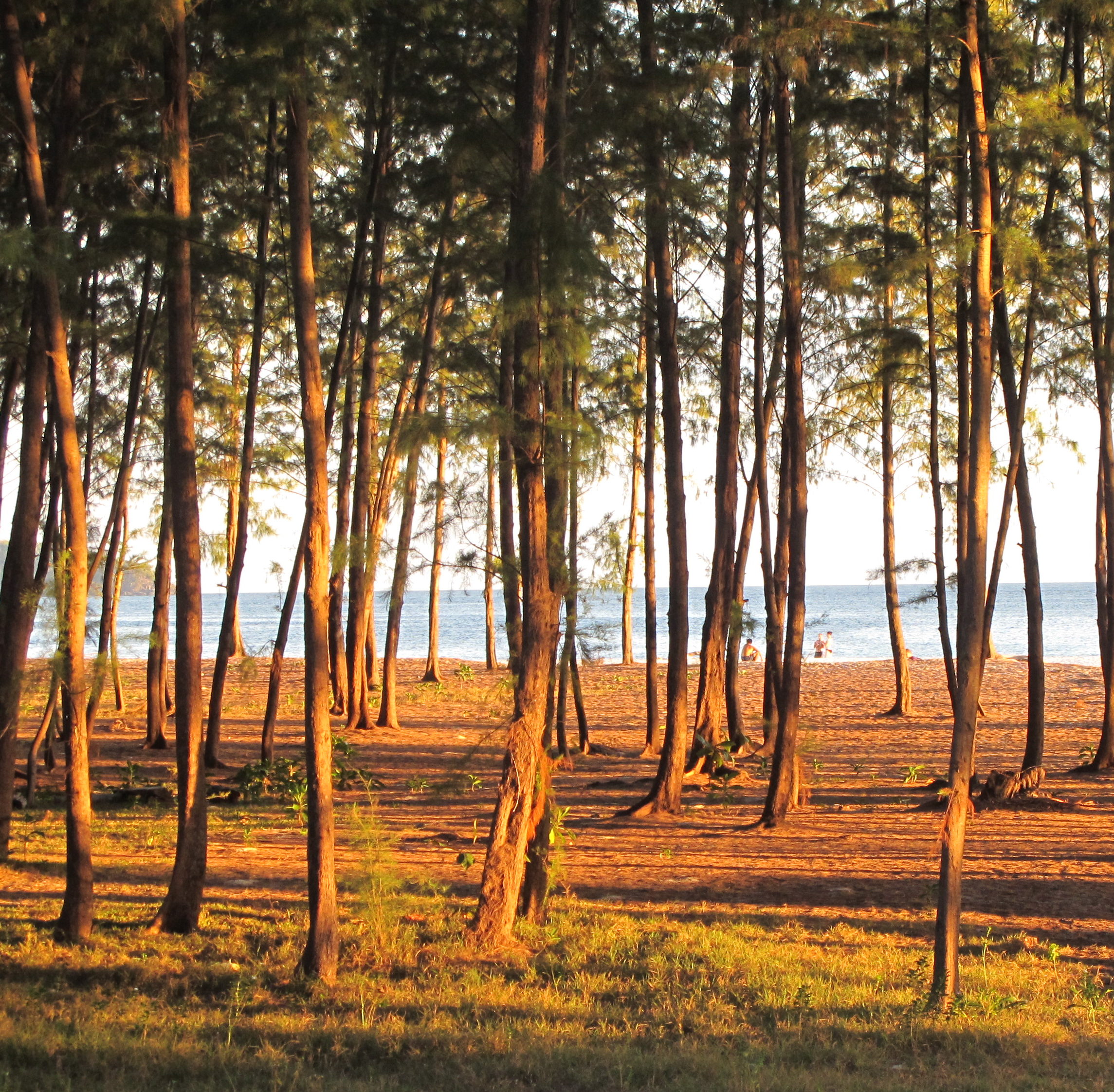
Adang Island is barely inhabited because it has little flat ground. A few families live on the eastern shore, there are bagats, or seasonal settlements, along the western shore, and a national park substation at Laem Son has camping and modest accommodations for a few visitors. Laem Son, where we camp, is a forested beach where ocean currents, rounding the island have deposited sandat the base of Chado Cliff. Laem Son is an inviting place, shaded by Casuarina trees that sway with the seasonal winds, though when the winds blow hard the Causarina may fall, causing commotion in the camping area and sometimes damaging national park structures.
‘Sea Pine’ or Son Thale in Thai. They are not really pine, but Horsetail Casuarina (Casuarina equisetifolia). This tree grows on tropical beaches throughout the coastal Indo-Pacific and is related to the tamarisk trees that have been introduced to the warm desert regions of North America.
Casuarina are salt tolerant. When a new strand of sandy beach is established by shifting currents — common enough around Laem Son — Casuarina seedlings take hold at top fringe of the intertidal zone. If the strand persists, the Casuarina will grow tall in just a few years. Their dusty green needles extrude salt on winter mornings.
Fast growing ‘sea pine’ (Casuarina equisetifolia), barely ten years old, grow on the new beach at Laem Son in this image from February 2012.
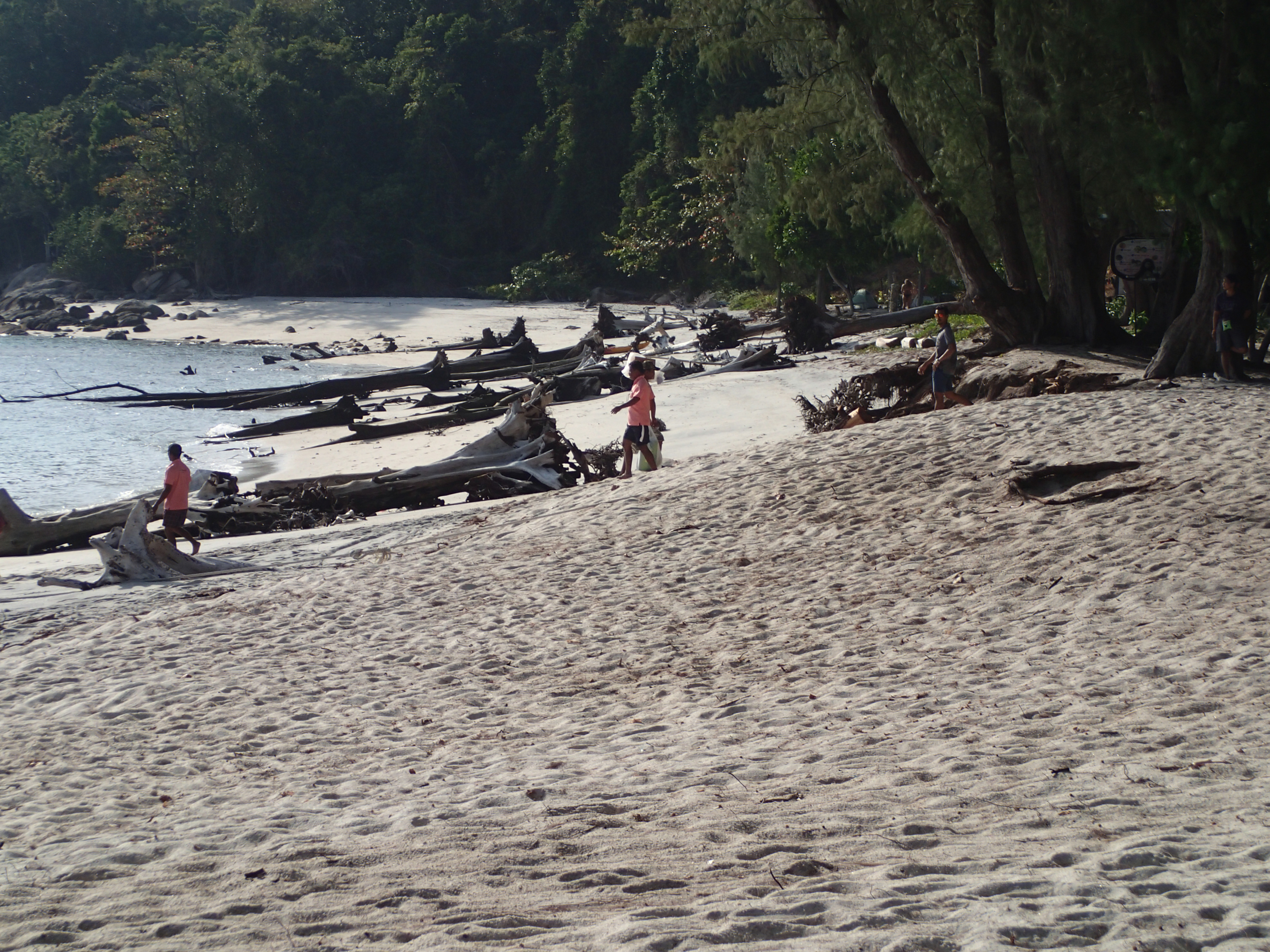
Starting about twenty years ago, something changed in the play of the wind and ocean currents, and Laem Son was reconfigured. Before the turn of the century, sand had extended southwards in a large expanse covered by mature Casuarina. Between 1997 and 2001, most of this sand was dislodged by strong wind-driven currents that came in from the southwest during the summer monsoon season and stripped it away. Some of that sand was redeposited to the southeast, but much seems to have settled into the channel, so the amount of land above sea level is less than before. Many hectares of old beach, shaded under mature Casuarina trees, was swept away, along with a pier, a restaurant and a visitor center. This process continues to date. Every year the ocean cuts back toward granite cliffs on the western part of Laem Son, undercutting and toppling large Casuarina trees into the sea. The beach is growing out eastward, but it seems the amount of dry sand removed exceeds the amount deposited.
Casuarina seedlings that started growing on new beach 15-16 years ago are now more than 30 meters (100 feet). The fringing coral reef (dominated by massive Porites corals) is far enough from shore so that most of the beach movement occurred within its perimeter and many of the ancient coral heads survived. Out at the tip of Laem Son, there is a seasonal spit of sand. We always see it in February, hooking clockwise. But the fishermen from Lipe Island and the park officials say that it disappears completely under the summer monsson, then forms again when the wind and surface currents shift back to northeast under the winter regime. Satellite imagery confirms what they say is true.
As beach in the west is cut back year by year, mature Casuarina topple into the sea (2015).
Meanwhile, sand is deposited, forming new beach to the east. The sand spit in the back is a seasonal feature of Laem Son. It forms every winter and is washed away every summer (2012).
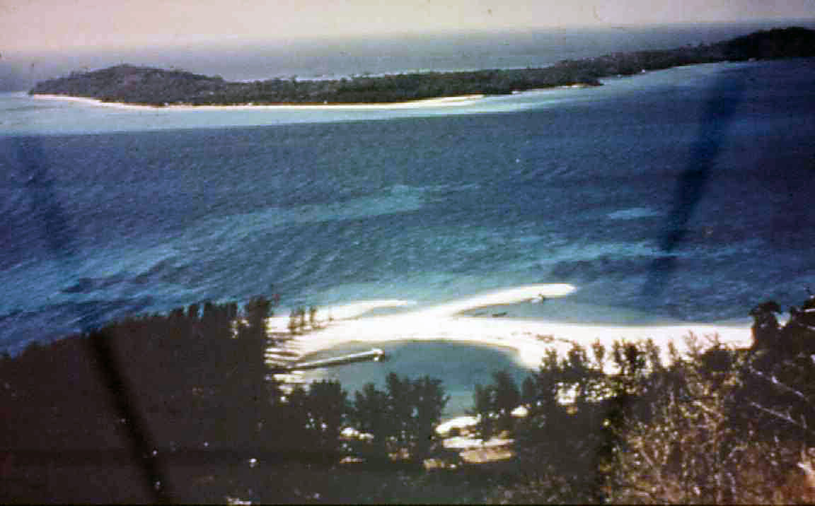
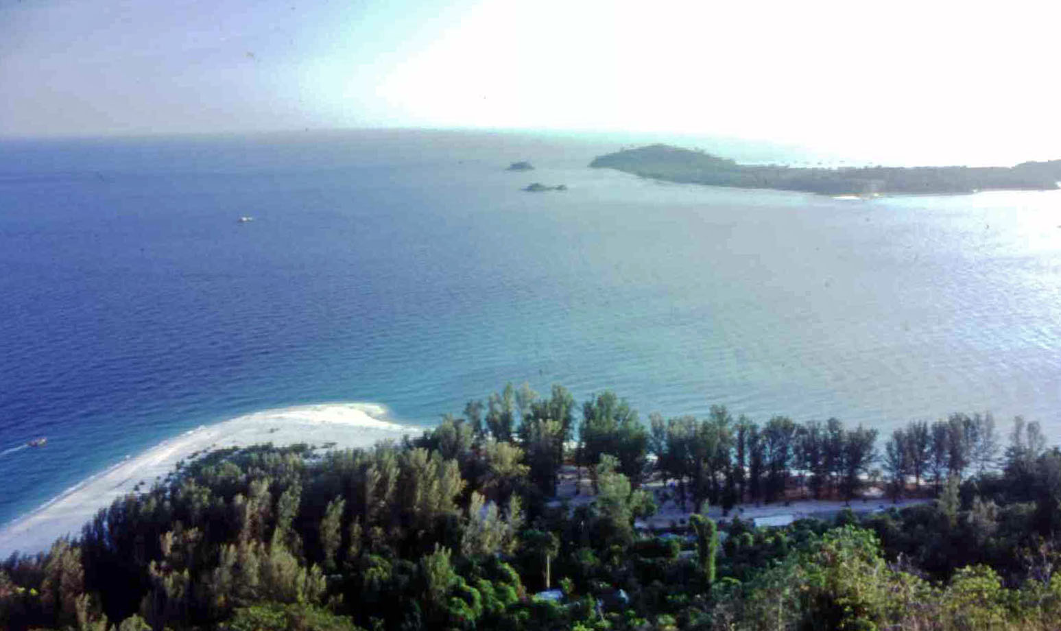
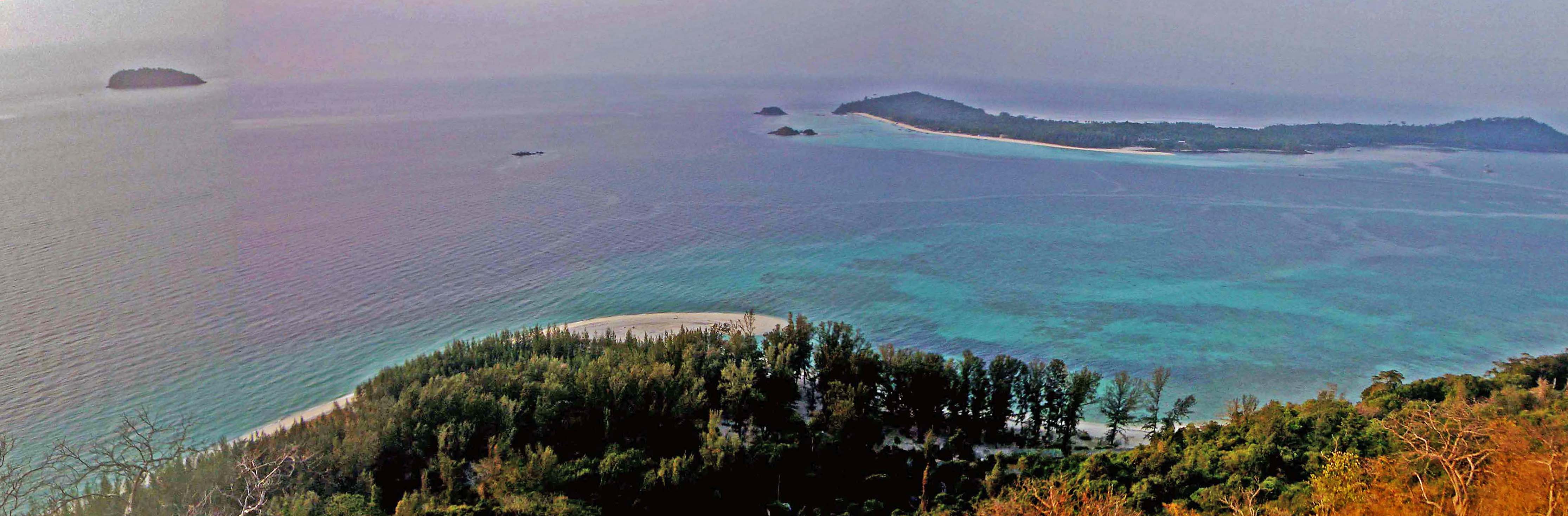
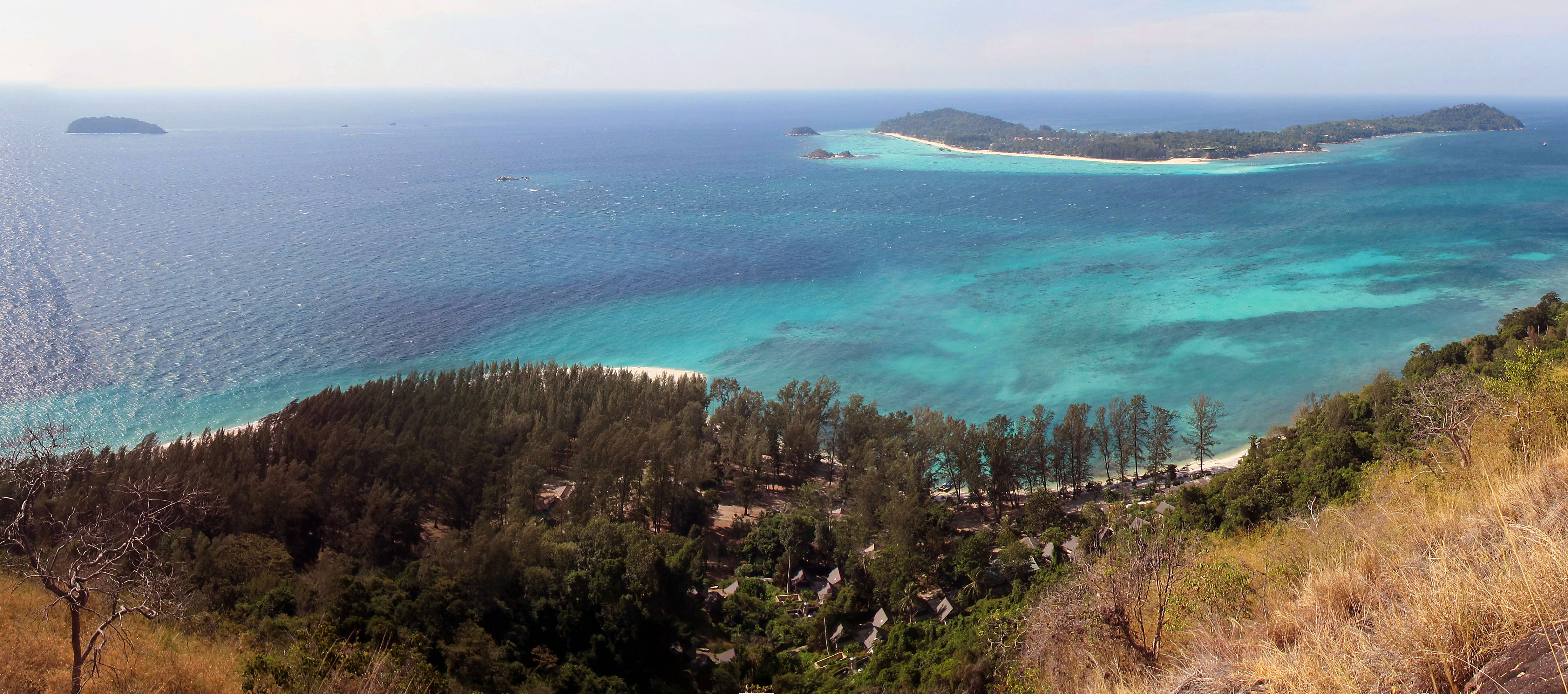
Every year, we make the sweaty climb a couple of hundred meters up to the top of Chado cliff to photograph Laem Son, with Lipe Island in the distance. The view is best from Viewpoint #3 at the top of the granite spur, but it is always tempting to halt at partway up at Viewpoint #1. Here is a photo sequence that shows a quarter century of change in the configuration of Laem Son from 1993-2017. All of these pictures were taken in January – February.
Laem Son in 1993, courtesy Tarutao National Park
1994 – The pier was built before sand closed the lagoon. In the early 1990s, Laem Son was growing eastward (to the right). Note the Causarina seedlings growing on the outer bank of the lagoon
1995 – The Causarina seedlings are taller after a year. Note Lipe island also has a sand spit pointing east (above Joanne’s left shoulder). The sand spit is re-formed every year by winter winds from the northeast. It disappears under southwest winds of the summer monsoon.
2001 – The right side of Laem Son disappeared at the turn of the century, along with the lagoon, the pier, several national park structures and countless hulking Casuarina trees. Some of this sand is repositioned to the east. The new sand is covered in pioneering Casuarina seedlings.
2005 – The western part of Laem Son continues to erode back toward Adang Island’s steep granite bedrock. Casuarina trees on the new beach to the east are taller now.
2010 – Trees on the east side of Laem Son are tall now. The beach on the west is being cut back at a meter or so per year, threatening old park structures. New structures have been constructed on the hill, or on the largest expanse of flat sand which is now the western part of Laem Son.
2017 – The western part of Laem Son continues to cut back toward the cliffs and most of the old Casuarina on that side have fallen into the water. Forest to the east has matured. Some of the trees that established in the late 1990s are now more than 30 meters tall. Sometimes they blow over in the wind. Note the resort development on Koh Lipe. In the past 25 years, it has become nearly completely built-out.
We suppose that the position of the beach is controlled by the relative power of the summer and winter monsoon, expressed by the strength of the wind-driven surface currents that come from the southwest in summer and the northeast in winter. Anecdotally, the winter northeast monsoon was strong in the 1990s. I remember 1993-1996 in particular as a time when inter-island boats would creak as they rode into swells of chop that might be three meters tall. There were days when our group was confined to Laem Son because it was too windy for a longtail boat to cross the channel between Adang and Lipe, the next island over. That was a time a big tree, rooted in sand, fell and destroyed part of the dining area, fortunately after eating hours.
Since the turn of the Century, perhaps winds have been relatively stronger from the southwest. Now there a solid bluff of beachhead running northward along the east side of Laem Son. To the west, ocean has stripped sand from bare rock clear to the edge of the forest. What was once a sandy stroll to the old Customs House is now an arduous rock hop.
Here’s an animation that shows in map view how the beach has moved through the years, as measured by Wildlands Studies team members who walk the beach with a GPS.